shape
carat
color
clarity

Hurricane Season officially starts June 1. Mother nature said hold my beer.

Arcadian

Ideal_Rock
Premium
Joined
Sep 17, 2008
Messages
9,393
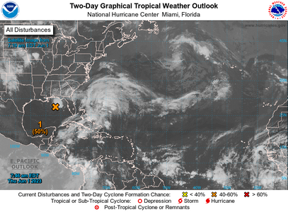
05-31-2023two_atl_2d0.png
 
@Arcadian I cant say I'm happy to see this thread!:lol:
(Thank you for doing it though)

Let's hope Mother Nature is kind to us this season!
 
10 day forecast looks clear where I’m at:

IMG_0300.png
 

Attachments

  • 045F1B52-8096-4E2C-B7FD-A7C13A123755.jpeg
    045F1B52-8096-4E2C-B7FD-A7C13A123755.jpeg
    294.9 KB · Views: 28
HI:

Always a scary, but informative thread!!! Hold fast!!

cheers--Sharon
 
Thank you for coming back year after year to update on all the hurricane activity. I feel like this year will be very active, hoping to be proven wrong!
 
It's always something and generally multiple somethings (in my experience).
Here's hoping we all stay safe this hurricane season :pray:
 
@tyty333 certainly not the thread I wanted to make! Last year was something else. this year promising to be more of the same. I'm not ready!!

Our little yellow x is now orange so I think its probably going to be Arlene.

@monarch64 you're in Destin? Gorgeous there! We're in for a lovely weekend...lol I think you'll be fine there.

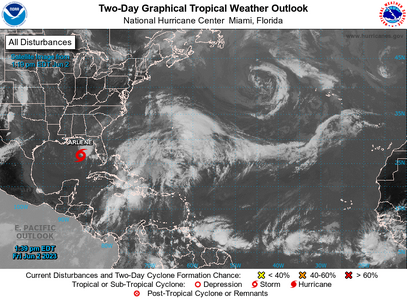
06-01-23two_atl_2d0.png


ZCZC MIATWOAT ALL
TTAA00 KNHC DDHHMM

Tropical Weather Outlook
NWS National Hurricane Center Miami FL
800 AM EDT Thu Jun 1 2023

For the North Atlantic...Caribbean Sea and the Gulf of Mexico:

1. Northeastern Gulf of Mexico (AL91):
Showers and thunderstorms associated with an area of low pressure
over the northeastern Gulf of Mexico have increased and become
better organized during the overnight hours. Environmental
conditions appear marginally favorable for additional development
over the next day or so, and a short-lived tropical depression or
storm could form over that time span as the system meanders over the
northeastern Gulf of Mexico. However, by this weekend environmental
conditions are forecast to become unfavorable for additional
development as the system drifts southward, likely remaining
offshore over the Gulf of Mexico. An Air Force Reserve Hurricane
Hunter aircraft is scheduled to investigate the system later today,
if necessary.


Regardless of development, locally heavy rainfall could occur over
portions of the Florida Peninsula through this weekend. Additional
information on the rainfall and flooding potential can be found in
products issued by your local National Weather Service forecast
office and Excessive Rainfall Outlooks issued by the Weather
Prediction Center.

* Formation chance through 48 hours...medium...50 percent.
* Formation chance through 7 days...medium...50 percent.


Today marks the first day of the Atlantic hurricane season, which
will run until November 30.
The long-term averages for the number of
named storms, hurricanes, and major hurricanes are 14, 7, and 3,
respectively.

The list of names for 2023 is as follows:


NamePronunciationNamePronunciation
Arlenear-LEENLeelee
BretbretMargotMAR-go
CindySIN-deeNigelNY-juhl
DondahnOpheliao-FEEL-ya
EmilyEH-mih-leePhilippefee-LEEP
FranklinFRANK-linRinaREE-nuh
GertgerSeanshawn
HaroldHAIR-uldTammyTAM-ee
Idaliaee-DAL-yaVincevinss
Joseho-ZayWhitneyWHIT-nee

This product, the Tropical Weather Outlook, briefly describes
significant areas of disturbed weather and their potential for
tropical cyclone formation during the next seven days. The issuance
times of this product are 2 AM, 8 AM, 2 PM, and 8 PM EDT. After the
change to standard time in November, the issuance times are 1 AM, 7
AM, 1 PM, and 7 PM EST.

A Special Tropical Weather Outlook will be issued to provide
updates, as necessary, in between the regularly scheduled issuances
of the Tropical Weather Outlook. Special Tropical Weather Outlooks
will be issued under the same WMO and AWIPS headers as the regular
Tropical Weather Outlooks.

A standard package of products, consisting of the tropical cyclone
public advisory, the forecast/advisory, the cyclone discussion, and
a wind speed probability product, is issued every six hours for all
ongoing tropical cyclones. In addition, a special advisory package
may be issued at any time to advise of significant unexpected
changes or to modify watches or warnings.

NHC has the option to issue advisories, watches, and warnings for
disturbances that are not yet a tropical cyclone, but which pose the
threat of bringing tropical storm or hurricane conditions to
land areas within 48 hours. For these land-threatening "potential
tropical cyclones", NHC will issue the full suite of advisory and
watch/warning products. Potential tropical cyclones share the
naming conventions currently in place for tropical depressions,
being numbered from a single list (e.g., "One", "Two", "Three",
etc.).

The Tropical Cyclone Update is a brief statement to inform of
significant changes in a tropical cyclone, to post or cancel watches
or warnings, or to provide hourly position updates between
intermediate advisories when the storm center is easily followed by
radar. It is used in lieu of or to precede the issuance of a
special advisory package. Tropical Cyclone Updates, which can be
issued at any time, can be found under WMO header WTNT61-65 KNHC,
and under AWIPS header MIATCUAT1-5.

All NHC text and graphical products are available on the web at
https://www.hurricanes.gov. More information on NHC text and
graphical products can be found at
https://www.nhc.noaa.gov/pdf/NHC_Product_Description.pdf. New and
updated products for the 2023 season can be found at

You can also interact with NHC on Facebook at
https://www.facebook.com/NWSNHC. Notifications are available via
Twitter when select National Hurricane Center products are issued.
Information about our Atlantic Twitter feed (@NHC_Atlantic) is
available at https://www.hurricanes.gov/twitter.php.

Forecaster Papin/Cangialosi/Brown
 
Now at 70% and a air recon is taking place right now.

Current guidance says that whatever this turns into (likely if anything a weak tropical storm) then it will go south into cuba and dissipate there. does mean we're still gonna get some of that on the peninsula tho.

At worst, FL gets a bunch of rain and some flooding in some parts, but chances of this being little more than a rainmaker is really not very high (which I will take!)
 
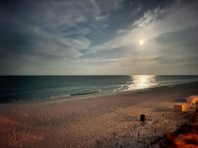
@Arcadian yes, we’re in Destin. The ocean was ROUGH today. Yellow flags in the am and red flags after noon. Probably has absolutely nothing to do with current tropical items of interest but it’s rare to see the water that choppy verging towards actual surfable waves here!

This is the first time I’ve taken my daughter here. When we drove over the bridge from Okaloosa Island into Destin she said “why is there snow over there?!” She thought the white sand was snow. Lol

So many of the beaches up there are absolutely beautiful. I'm glad your daughter has had the chance to experience it!

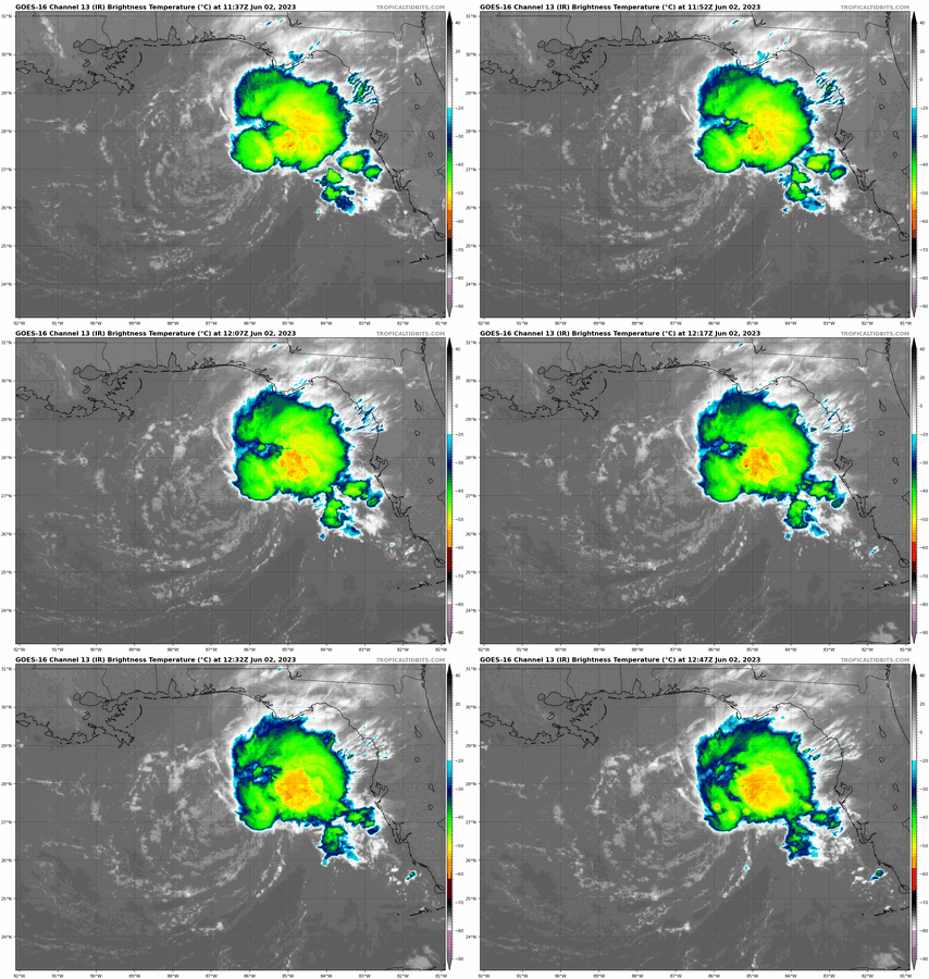
Actually the system would have some affect on the waters there being that the gulf is a basin more or less and the storm spins counter clockwise. And while its a small storm, I wouldn't call it tiny. The CENTER is tiny, absolutely, but its got a ton of convection to the east and north currently.

Moreso than NHC map, this is a better view in relation to where you are.
goes16_ir_02L_202306021137.gif
 
So many of the beaches up there are absolutely beautiful. I'm glad your daughter has had the chance to experience it!

Actually the system would have some affect on the waters there being that the gulf is a basin more or less and the storm spins counter clockwise. And while its a small storm, I wouldn't call it tiny. The CENTER is tiny, absolutely, but its got a ton of convection to the east and north currently.

Moreso than NHC map, this is a better view in relation to where you are.
goes16_ir_02L_202306021137.gif

Ohhhh, thank you for the insight! That makes a lot of sense. It’s a bright sunshiny morning but wow, the gulf is still a lot tougher than I’m used to. Even late last night it was looking and sounding angry. I don’t like to go out and fight the current to swim so I won’t be doing more than wading up to my knees. There are 5 pools on property so we’ll visit those I think. First pic is from about 2 am this morning, the others are from about half an hour ago (8:30 am CST)

A4AD0FF6-3902-408D-9A1B-A7090DDF15EE.jpeg
 

Attachments

  • IMG_0342.jpeg
    IMG_0342.jpeg
    174.8 KB · Views: 2
  • IMG_0341.jpeg
    IMG_0341.jpeg
    188.6 KB · Views: 2
@monarch64 be careful with any rip currents because they'll be out over the weekend.


Tropical Storm Arlene has formed
arlene_two_atl_2d0.png

000
WTNT42 KNHC 021724
TCDAT2

Tropical Storm Arlene Special Discussion Number 5
NWS National Hurricane Center Miami FL AL022023
100 PM CDT Fri Jun 02 2023

Data from the Air Force Hurricane Hunters indicate that the
depression has strengthened into a tropical storm. On the last leg
of the current mission, the aircraft found maximum 925
mb flight-level winds of around 50 kt and SFMR surface winds of
around 35 kt. Based on these data, Tropical Depression Two has
been upgraded to Tropical Storm Arlene with estimated peak winds of
35 kt.

Although the storm has strengthened slightly, we still expect
Arlene to weaken soon due to increasing wind shear and dry air, and
no change has been made to the forecast. The next forecast will be
issued at the normal time at 4 pm CDT.


FORECAST POSITIONS AND MAX WINDS

INIT 02/1800Z 26.7N 86.2W 35 KT 40 MPH
12H 03/0000Z 25.6N 86.2W 30 KT 35 MPH
24H 03/1200Z 24.2N 85.8W 25 KT 30 MPH
36H 04/0000Z 23.2N 84.9W 25 KT 30 MPH...POST-TROP/REMNT LOW
48H 04/1200Z...DISSIPATED

$$
Forecaster Cangialosi/Hogsett/Delgado


I will not be tracking this storm heavily considering its track takes it right into Cuba (unless it fires up again after that, but dosen't seem likely!)

Also for some super nerdy weather stuff, Dr. Cowan goes into a lot of detail about the upcoming season with some historical data.

 
GET 3 FREE HCA RESULTS JOIN THE FORUM. ASK FOR HELP
Top