shape
carat
color
clarity

The Atlantic is awake! Elsa has formed!

Arcadian

Ideal_Rock
Premium
Joined
Sep 17, 2008
Messages
9,344
This one still is deciding where to go but FL and gulf states should be on the lookout for this one. The models have high confidence of Elsa being a strong T-Storm or a low level hurricane, its just a matter of what side of FL she will hit. No model agreement on that yet.


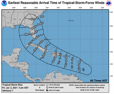
7-1-21two_atl_2d0.png
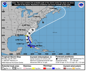
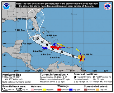
115028_5day_cone_no_line_and_wind.png
 
Oh great! :eek2:
A hurricane will help the search and rescue operation at that fallen condo in Florida. :(sad

Plus they just paused operations because the side of the building that is still standing shows signs of possibly collapsing any minute.
High winds will not be helpful to a building that's on the verge of falling down.
 
Last edited:
Oh great! :eek2:
A hurricane will help the search and rescue operation at that fallen condo in Florida. :(sad

Plus they just paused operations because the side of the building that is still standing shows signs of possibly collapsing any minute.
High winds will not be helpful to a building that's on the verge of falling down.

And its being hampered anyway by the truly gross weather currently happening as it is. None of the outcomes are going to be good unfortunately. Saturday/Sunday will be a better idea of what track it could take but they can change direction all the way up to landfall.
 
I'm not ready (mentally) for another season!o_O:(2
 
letitblow.jpg

:lol:
 
Oh great! :eek2:
A hurricane will help the search and rescue operation at that fallen condo in Florida. :(sad

Plus they just paused operations because the side of the building that is still standing shows signs of possibly collapsing any minute.
High winds will not be helpful to a building that's on the verge of falling down.
That was my first thought, too.

Those poor people. :(
 
GFS is showing Elsa raking the coast, entering on the gulf side of FL, then going back offshore near the DC area, raking the coast again.

The reality is, most of us on the peninsula will feel it if it gets stronger and is a big storm (think Irma), even if it hits in the gulf and agreed, the worst time for this to happen because the way it floods down there, survival will be mimimal to none in that building.

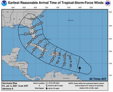
*adding to this image as Elsa is now a hurricane*

085943_earliest_reasonable_toa_no_wsp_34.png
122714_earliest_reasonable_toa_no_wsp_34.png

Speaking of, we're all still in the cone as there is still no model agreement. GFS goes in the gulf, CMC goes Atlantic side.

There's Air Recon occurring right now so its a wait and see.
 
Looks like we could be moving a bit more east on this storm. I think some are saying west, but the models I looked at seem to be pulling more east. Nevertheless, elsa is currently a big storm, way wider than the Florida Peninsula, so we will all feel this if it holds together.

East side of the storm is always the worst side because of the on flow surge. so if the storm stays west, the east coast of the peninsula will get hit the worst.

I'm hoping no one is making plans to be down here over the holiday. If so check airlines, cruises, Disney, etc, because you could end up being stranded.

154708_5day_cone_no_line_and_wind.png
 
FYI, Elsa is still out there but lots of confusion as to what is really going on. One camp says she'll die out the other says she'll stay a tropical storm. I'm going to wait until 8pm to gander whats going to happen but if it stays a tropical storm, we're gonna be getting wet in SoFL.
 
HI:

Thank you for the annual thread and updates.

cheers--Sharon
 
I actually was a bit remiss the last couple of days because our girl Elsa has been...weird.

So here's what I know? Right now we're getting some squall lines in SoFL, which will get worse tonight and tomorrow will be our day. I'm on the east coast of FL and will be on the dirty side of the storm (lots of storm surge, rain, tornadoes possible). Currently I've heard the Keys are getting some leading edge stuff. Again this is a big storm and its only 90 miles to Cuba.

Elsa being so big, means that if she makes it over Cuba intact, she will cover a most if not all of the Florida Peninsula at some point with the eye staying off shore until roughly Tampa or slightly north.

She will then be a land bound depression at that point and all points between (Georgia, South Carolina, North Carolina, Virginia) will get a little taste. They are predicting that she will be Atlantic bound by Friday if she keeps it together. @missy she could come for a visit, just saying. By the time she reaches Massachusetts I've seen numbers in the 900mb range.

This is now become a watch in real time type of storm for us down south. Those in the predicted path should plan accordingly.


145814_5day_cone_no_line_and_wind.png
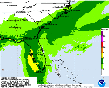
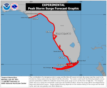
145814WPCQPF_sm.gif145814_peak_surge.png
 
Good luck @Arcadian ...I hope Elsa takes it easy on your area! Lord knows you could use a break!

I am out of the cone but definitely expect some leftover rain showers. My elderly but still in good shape parents will be in
the cone around Wednesday. I'm hoping that it would have died down a lot by then but who knows at this point?

Keep us posted @Arcadian !
 
Thanks for the heads up @Arcadian.

We will keep an eye on it.
Fingers crossed this season won't be too terrible regarding hurricanes and other storms.

Hope everyone stays safe.
 
We're really getting strong bands. 40 MPH gusts right now and these are just outter bands.
 
It is super still right now. Eerily so. Calm before the storm. The clouds are super heavy right now so will start raining here in a few. Keys are taking quite the beating right now.
114641_5day_cone_no_line_and_wind.png
 
Hopefully, it will keep on moving and not dump too much rain on you. I always hate waiting when I know something is headed our
way. At least this one is hitting as a TS and not a hurricane. I just checked my local area Facebook page. People new to our area
(there are a lot) are asking what to buy, should they gas up, how much water to buy etc... We arent even in the cone! I guess it's a
good "intro" storm for all the folks new to Florida.:))

yeah, my intro storm wasn't so nice but it was a teachable moment!! Thankfully all that blizzard experience came in handy (seriously its near the same just flipped to summer) so I was good, mostly. I'm not in the cone either but its still freaky down here. The convection is being blown north and east currently so we're getting lots of rain/t-storms currently.

Generator is ready to go because we've lost electricity during some nasty rains recently. As gross as it is, I don't want to sit in the dark with 2 60lb+ dogs trying to climb into my lap without any AC :lol:

Updates comes out at 11am. will see if there's a easterly track going on. I believe hurricane hunters were grounded because of too much lightening.
 
Stay safe all!! I’m sure we’ll see the remnants up here in the Northeast. Sometimes worse than you down there in fact… fingers crossed for us all for Elsa and this season!
 
Its still firing up down here, air is super thick and my head is pounding. Orlando Airport is closing at 5pm today. West Palm Beach airport has lots of delays. Anyone flying in or out of FL should check with their airline as I hear that they are waiving change fees today/tomorrow
 
Its looking like its teetering on being a hurricane once again.
180428_5day_cone_no_line_and_wind.png
 
Sending positive vibes that everyone will stay safe.
 
We are in the cone but I'm not concerned. This should be pretty minor, I think. We only stock up on things when it looks like it is going to be a strong 3 or above.
 
It’s been upgraded again. Be safe everyone!
 
Per the 20:00 advisory its now a cat 1. Its a gnarly one, thats got a lot of lightening, wind, and rain. West side folks, please take care.

BULLETIN
Hurricane Elsa Intermediate Advisory Number 27A...Corrected
NWS National Hurricane Center Miami FL AL052021
800 PM EDT Tue Jul 06 2021

Corrected to add hurricane wind radii

...ELSA REGAINS HURRICANE STATUS SOUTHWEST OF TAMPA BAY...
...RECONNAISSANCE AIRCRAFT EN ROUTE TO INVESTIGATE THE HURRICANE...


SUMMARY OF 800 PM EDT...0000 UTC...INFORMATION
----------------------------------------------
LOCATION...26.6N 83.1W
ABOUT 100 MI...165 KM SSW OF TAMPA FLORIDA
MAXIMUM SUSTAINED WINDS...75 MPH...120 KM/H
PRESENT MOVEMENT...N OR 360 DEGREES AT 14 MPH...22 KM/H
MINIMUM CENTRAL PRESSURE...996 MB...29.41 INCHES


WATCHES AND WARNINGS
--------------------
CHANGES WITH THIS ADVISORY:

The Tropical Storm Warning for the Lower Florida Keys from Key West
to the Seven Mile Bridge has been discontinued.

SUMMARY OF WATCHES AND WARNINGS IN EFFECT:

A Storm Surge Warning is in effect for...
* West coast of Florida from Bonita Beach to the Aucilla
River, including Tampa Bay

A Hurricane Warning is in effect for...
* Egmont Key to the Steinhatchee River, Florida

A Tropical Storm Warning is in effect for...
* The Dry Tortugas
* West coast of Florida from Flamingo to south of Egmont Key
* West coast of Florida north of Steinhatchee River to Ochlockonee
River
* Coast of Georgia from the Mouth of the St. Marys River to
Altamaha Sound

A Storm Surge Watch is in effect for...
* West of the Aucilla River to the Ochlockonee River, Florida

A Tropical Storm Watch is in effect for...
* North of Altamaha Sound, Georgia, to South Santee River, South
Carolina

A Storm Surge Warning means there is a danger of life-threatening
inundation, from rising water moving inland from the coastline,
in the indicated locations. For a depiction of areas at risk,
please see the National Weather Service Storm Surge Watch/Warning
Graphic, available at hurricanes.gov. This is a life-threatening
situation. Persons located within these areas should take all
necessary actions to protect life and property from rising water
and the potential for other dangerous conditions. Promptly follow
evacuation and other instructions from local officials.

A Hurricane Warning means that hurricane conditions are expected
somewhere within the warning area, in this case within the next 12
to 24 hours. Preparations to protect life and property should be
rushed to completion.

A Tropical Storm Warning means that tropical storm conditions are
expected somewhere within the warning area.

A Storm Surge Watch means there is a possibility of life-
threatening inundation, from rising water moving inland from the
coastline, in the indicated locations. For a depiction of areas at
risk, please see the National Weather Service Storm Surge
Watch/Warning Graphic, available at hurricanes.gov.

A Tropical Storm Watch means that tropical storm conditions are
possible within the watch area.

Interests elsewhere in the Carolinas and the mid-Atlantic coast
should monitor the progress of Elsa.

For storm information specific to your area in the United
States, including possible inland watches and warnings, please
monitor products issued by your local National Weather Service
forecast office. For storm information specific to your area
outside of the United States, please monitor products issued by
your national meteorological service.


DISCUSSION AND OUTLOOK
----------------------
At 800 PM EDT (0000 UTC), the center of Hurricane Elsa was located
by NOAA Doppler weather radars near latitude 26.6 North, longitude
83.1 West. Elsa is moving toward the north near 10 mph (22 km/h),
and this general motion is expected to continue through tonight. A
turn toward the north-northeast is expected on Wednesday, followed
by a faster northeastward motion by late Thursday. On the forecast
track, Elsa will move near or over portions of the west coast of
Florida later tonight and early Wednesday morning. Elsa is forecast
to make landfall along the north Florida Gulf coast by late
Wednesday morning and then move across the southeastern United
States through Thursday.

Data from the NOAA Doppler weather radar in Tampa Bay indicate that
maximum sustained winds are near 75 mph (120 km/h) with higher
gusts. Some additional slight strengthening will be possible
overnight. Weakening will begin after Elsa moves inland by late
Wednesday morning.

Hurricane-force winds extend outward up to 20 miles (32 km) from
the center. Tropical-storm-force winds extend outward up to 90 miles
(150 km) from the center. Buoy 42013, located due north of Elsa,
recently measured a peak 1-minute sustained wind of 38 mph (61 km/h)
gusting to 47 mph (76 km/h). A wind gust to 43 mph (69 mph) was
recently measured on North Captiva Island.

The estimated minimum central pressure is 996 mb (29.41 inches).


HAZARDS AFFECTING LAND
----------------------
Key messages for Elsa can be found in the Tropical Cyclone
Discussion under AWIPS header MIATCDAT5, WMO header WTNT45 KNHC and
on the web at
www.hurricanes.gov/graphics_at5.shtml?key_messages.

WIND: Hurricane conditions are expected within the Hurricane Warning
area on the Florida Gulf coast beginning this evening. Tropical
storm conditions will continue over portions of the warning area in
the Florida Keys through this evening. Tropical storm conditions
are expected to spread northward into west-central Florida and the
Florida Big Bend region in the warning areas tonight and early
Wednesday. Tropical storm conditions are expected in the Tropical
Storm Warning area along the Georgia coast by late Wednesday and are
possible in the watch area in Georgia and South Carolina Wednesday
night and early Thursday.

STORM SURGE: The combination of a storm surge and the tide will
cause normally dry areas near the coast to be flooded by rising
waters moving inland from the shoreline. The water could reach the
following heights above ground somewhere in the indicated areas if
the peak surge occurs at the time of high tide...

Englewood, FL to Aucilla River including Tampa Bay...3 to 5 ft
Bonita Beach, FL to Englewood, FL including Charlotte Harbor...2 to
4 ft
Aucilla River to Ochlockonee River...2 to 4 ft
Flamingo, FL to Bonita Beach, FL...1 to 3 ft
Ochlockonee River to Indian Pass...1 to 2 ft
Mouth of St. Marys River to South Santee River, SC...1 to 2 ft

Surge-related flooding depends on the relative timing of the surge
and the tidal cycle, and can vary greatly over short distances. For
information specific to your area, please see products issued by
your local National Weather Service forecast office.

RAINFALL: Across portions of Cuba through tonight, outer bands south
of Elsa will produce an additional 1 to 3 inches of rainfall.
Isolated storm totals of 15 inches are expected, which will maintain
areas of significant flash flooding and mudslides through tonight.

Elsa is expected to produce the following rainfall amounts and
impacts this week:

Across the Florida Keys into southwest and western portions of the
Florida Peninsula...3 to 6 inches with localized maximum totals up
to 9 inches through Wednesday, which may result in considerable
flash and urban flooding, along with minor to isolated moderate
river flooding.

Across the rest of Florida...2 to 4 inches with localized maximum
totals up to 6 inches through Wednesday night, which may result in
considerable isolated flash and urban flooding along with minor to
isolated moderate river flooding.

Across portions of southeast Georgia and the Lowcountry of South
Carolina, 3 to 5 inches with isolated maximum totals up to 8 inches
will be possible, which may result in considerable flash and urban
flooding.

Across coastal portions of North Carolina into southeastern
Virginia...1 to 3 inches with isolated totals up to 5 inches
Wednesday night through Thursday night, which could lead to isolated
flash and urban flooding.

TORNADOES: A few tornadoes are possible through tonight across the
Florida Peninsula. The tornado threat will continue on Wednesday
across north Florida, southeast Georgia, and the Lowcountry of
South Carolina. The tornado threat should shift to the eastern
Carolinas and far southeast Virginia on Thursday.

SURF: Swells will spread northward across portions of the Florida
Keys and the west coast of Florida through early Wednesday. These
swells are likely to cause life-threatening surf and rip current
conditions. Please consult products from your local weather office
for more details.


NEXT ADVISORY
-------------
Next complete advisory at 1100 PM EDT.
 
We are in the cone but I'm not concerned. This should be pretty minor, I think. We only stock up on things when it looks like it is going to be a strong 3 or above.

You don't have to answer but are you in the Tampa area? Thats the only area I worry about because like Miami, it floods if you spit.
 
You don't have to answer but are you in the Tampa area? Thats the only area I worry about because like Miami, it floods if you spit.

Yes- Tampa. Luckily, we moved houses last year and we are now in flood zone x. Prior to that, we lived in the first evacuation zone across the street from a canal that fed directly into the bay.

It's much more comfortable now, but at our old house, even though it sat a good elevation, storms were much more worrisome.

Tampa and surrounding areas flood like crazy.

OK, thank you, I don't worry so much now.
 
How did everyone fare overnight? We got some rain some wind but all is OK here.
There's some intensification happening as we speak so she's getting energy for the rest of her journey it appears.

Keep in mind that Elsa is a big storm and once it crosses over will start pulling from the Atlantic Ocean. Also remember the spin is counter clockwise so it will pull water from the Atlantic inward. FL and everyone else will get some tails out of this one for sure.

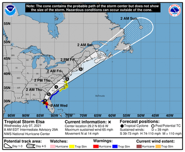
115653_5day_cone_no_line_and_wind.png
 
GET 3 FREE HCA RESULTS JOIN THE FORUM. ASK FOR HELP
Top