You are using an out of date browser. It may not display this or other websites correctly.
You should upgrade or use an alternative browser.
You should upgrade or use an alternative browser.
The Atlantic is awake! Elsa has formed!
- Thread starter Arcadian
- Start date
PreRaphaelite
Ideal_Rock
- Joined
- Feb 2, 2015
- Messages
- 3,564
- Joined
- Sep 17, 2008
- Messages
- 9,344
Glad it was uneventful! we only have 5 more months to go

Seriously.
Folks, get your trees trimmed away from houses and roofs while you have time! Always surprises me that so many don't do that. I have a tree company come out twice a year. They came out earlier in the spring. I have some palms that already need it again!
Lots of tree branches and dead parts of trees down today on way to office.
- Joined
- Sep 17, 2008
- Messages
- 9,344
Seriously.
Folks, get your trees trimmed away from houses and roofs while you have time! Always surprises me that so many don't do that. I have a tree company come out twice a year. They came out earlier in the spring. I have some palms that already need it again!
Lots of tree branches and dead parts of trees down today on way to office.
FPL was just in my neighborhood (even over the holiday weekend) replacing line and having trees cut back. Admittedly they do a for crap job but better than nothing.
I will say I'm slightly guilty but its a single tree on the side yard that needs to be trimmed back. I'm now getting spiders in my bathroom so its past time.
- Joined
- Jun 2, 2013
- Messages
- 3,413
Thanks ever so much for your Atlantic hurricane season PSAs, @Arcadian -- here's hoping that the reality is better than the current hurricane forecasts for the upcoming months!
- Joined
- Apr 19, 2004
- Messages
- 26,337
Glad it was uneventful! we only have 5 more months to go

Stay safe. Send your scents my way! I'll keep them from harm!!!!
- Joined
- Jun 8, 2008
- Messages
- 54,801
Glad everyone is doing well and Elsa has passed by you.
We are expecting her overnight into tomorrow AM. I believe it will consist of strong winds and many inches of rain so flooding and power outages are predicted here. I am glad it will not be too drawn out a storm though and hoping she passes without doing much damage. Fingers crossed.
I have a feeling it will be a long hurricane season this year. Just my gut feeling.
We are expecting her overnight into tomorrow AM. I believe it will consist of strong winds and many inches of rain so flooding and power outages are predicted here. I am glad it will not be too drawn out a storm though and hoping she passes without doing much damage. Fingers crossed.
Glad it was uneventful! we only have 5 more months to go

I have a feeling it will be a long hurricane season this year. Just my gut feeling.
- Joined
- Sep 17, 2008
- Messages
- 9,344
I'm glad I've been able to help and give a heads up. Upper gulf experienced a lot of flooding. Lots of low lying areas in coastal SC also got lot of flooding, so it is quite the issue! The chances of flooding are real and Elsa said forget Disney and is chugging along at 40mph. Its moving faster now which is good. There's another little system thats being tracked that already brought a lot of flooding to Texas.
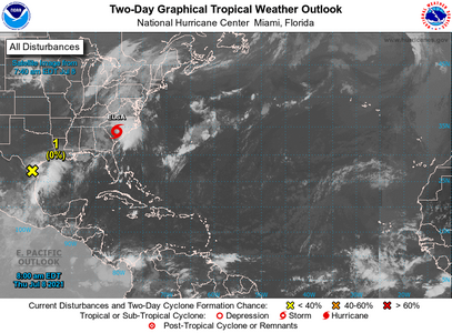
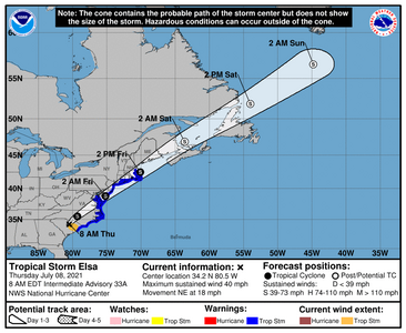
Really decent graphics is https://www.windy.com/ and thats really just for those who are in the path and want to see where its going. So far there's still model agreement in the track going forward, however intensity is kind of a big issue as no one knows that. Once the storm gets back on water which will be around DC, it will start to push water onshore and could get stronger (we all hope not!) . I keep hoping it breaks apart before that but isn't looking that way.
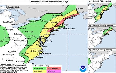
I've already warned people I work with in DC...2 weeks ago...lol Just glad that many will be watching and taking it seriously up there.
@canuk-gal LOL and you'll be happy to know I'm getting a particularly rare Guerlain coming to me soon.
@missy Last year just hurt. But yeah ain't over by a long shot!


Really decent graphics is https://www.windy.com/ and thats really just for those who are in the path and want to see where its going. So far there's still model agreement in the track going forward, however intensity is kind of a big issue as no one knows that. Once the storm gets back on water which will be around DC, it will start to push water onshore and could get stronger (we all hope not!) . I keep hoping it breaks apart before that but isn't looking that way.

I've already warned people I work with in DC...2 weeks ago...lol Just glad that many will be watching and taking it seriously up there.
@canuk-gal LOL and you'll be happy to know I'm getting a particularly rare Guerlain coming to me soon.
@missy Last year just hurt. But yeah ain't over by a long shot!
- Joined
- Feb 2, 2016
- Messages
- 12,108
- Joined
- Dec 17, 2008
- Messages
- 27,710
- Joined
- Jun 8, 2008
- Messages
- 54,801
I woke to torrential downpours at 2:30 AM and they are still continuing. Some very strong wind gusts as well. So far so good and the meteorologists are predicting (so we don't know if this is accurate or not as I find them to be wrong more often than right lately) the rain will end at 10AM EST. We shall see.
Yesterday there was some strong thunder and lightning in the mid afternoon and some rain but not too bad. That wasn't due to Elsa. Elsa arrived in the middle of the night and when I woke at 2:30 AM she was in full force here.
That's my update for now.
Hope everyone is safe and comfortable with electricity and AC.
- Joined
- Sep 17, 2008
- Messages
- 9,344
Glad that all is well @missy
Elsa is moving at a decent clip so you should see things subside there about mid morning or early afternoon.
Currently at 1000MB, she's gusting at near 60MPH close to the core. With a sustained wind at 45 Kts thats 50-51MPH so , pretty dangerous especially in the NE Corridor.
A TROPICAL STORM WARNING IS IN EFFECT FOR...
* LITTLE EGG INLET TO SANDY HOOK...NEW JERSEY
* LONG ISLAND FROM EAST ROCKAWAY INLET TO THE EASTERN TIP ALONG THE
SOUTH SHORE AND FROM PORT JEFFERSON HARBOR EASTWARD ON THE NORTH
SHORE
* NEW HAVEN...CONNECTICUT TO MERRIMACK RIVER...MASSACHUSETTS
INCLUDING CAPE COD...BLOCK ISLAND...MARTHA'S VINEYARD...AND
NANTUCKET
A TROPICAL STORM WARNING MEANS THAT TROPICAL STORM CONDITIONS ARE
EXPECTED SOMEWHERE WITHIN THE WARNING AREA.
FOR INFORMATION ON WIND HAZARDS NORTH OF THE TROPICAL STORM WARNING
AREA...PLEASE SEE PRODUCTS FROM YOUR LOCAL WEATHER OFFICE.
TROPICAL STORM CENTER LOCATED NEAR 39.4N 74.3W AT 09/0900Z
POSITION ACCURATE WITHIN 25 NM
PRESENT MOVEMENT TOWARD THE NORTHEAST OR 45 DEGREES AT 27 KT
ESTIMATED MINIMUM CENTRAL PRESSURE 1000 MB
MAX SUSTAINED WINDS 45 KT WITH GUSTS TO 55 KT.
34 KT....... 70NE 140SE 0SW 0NW.
12 FT SEAS.. 0NE 210SE 0SW 0NW.
WINDS AND SEAS VARY GREATLY IN EACH QUADRANT. RADII IN NAUTICAL
MILES ARE THE LARGEST RADII EXPECTED ANYWHERE IN THAT QUADRANT.
The thing in Texas was just...weird. It was a pretty hefty looking low that dumped a bunch of rain.
- Joined
- Jun 8, 2008
- Messages
- 54,801
Glad that all is well @missy
Elsa is moving at a decent clip so you should see things subside there about mid morning or early afternoon.
Currently at 1000MB, she's gusting at near 60MPH close to the core. With a sustained wind at 45 Kts thats 50-51MPH so , pretty dangerous especially in the NE Corridor.
A TROPICAL STORM WARNING IS IN EFFECT FOR...
* LITTLE EGG INLET TO SANDY HOOK...NEW JERSEY
* LONG ISLAND FROM EAST ROCKAWAY INLET TO THE EASTERN TIP ALONG THE
SOUTH SHORE AND FROM PORT JEFFERSON HARBOR EASTWARD ON THE NORTH
SHORE
* NEW HAVEN...CONNECTICUT TO MERRIMACK RIVER...MASSACHUSETTS
INCLUDING CAPE COD...BLOCK ISLAND...MARTHA'S VINEYARD...AND
NANTUCKET
A TROPICAL STORM WARNING MEANS THAT TROPICAL STORM CONDITIONS ARE
EXPECTED SOMEWHERE WITHIN THE WARNING AREA.
FOR INFORMATION ON WIND HAZARDS NORTH OF THE TROPICAL STORM WARNING
AREA...PLEASE SEE PRODUCTS FROM YOUR LOCAL WEATHER OFFICE.
TROPICAL STORM CENTER LOCATED NEAR 39.4N 74.3W AT 09/0900Z
POSITION ACCURATE WITHIN 25 NM
PRESENT MOVEMENT TOWARD THE NORTHEAST OR 45 DEGREES AT 27 KT
ESTIMATED MINIMUM CENTRAL PRESSURE 1000 MB
MAX SUSTAINED WINDS 45 KT WITH GUSTS TO 55 KT.
34 KT....... 70NE 140SE 0SW 0NW.
12 FT SEAS.. 0NE 210SE 0SW 0NW.
WINDS AND SEAS VARY GREATLY IN EACH QUADRANT. RADII IN NAUTICAL
MILES ARE THE LARGEST RADII EXPECTED ANYWHERE IN THAT QUADRANT.
The thing in Texas was just...weird. It was a pretty hefty looking low that dumped a bunch of rain.
We’re near Sandy Hook and we’re hoping we could cycle there in another two hours or so...not sure we will be able to depending on the winds and flooding.
- Joined
- Jan 3, 2013
- Messages
- 5,206
- Joined
- Feb 2, 2016
- Messages
- 12,108
Rain lots of rain, hardly any wind and the power is still on thankfully. I’m glad we don’t have a basement to worry about. However the back and front yards are flooded and that makes taking the dogs out a bit difficult.
Some folks we know in New Rochelle are pumping their basement out, they got hit pretty hard.
Some folks we know in New Rochelle are pumping their basement out, they got hit pretty hard.
- Joined
- May 15, 2014
- Messages
- 5,372


300x240.png)