shape
carat
color
clarity

Violent Weather - 2024 Edition

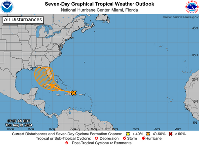
we got a direction y'all
1722515054586.png

Still not named.

But I want y'all to see this crazy model...its weird!

The GFS has done some crazy gymnastic loopdeloop stuff, crossing over to the Atlantic and exiting around Georgia and South Carolina, but being pushed back inland by the Bermuda High and coming back in about Jacksonville/St.Augustine area before being picked up by the high to go out again.

Basically this is what they're saying the currents will do as storms don't steer themselves.

The entire peninsula is getting rain from this system starting this weekend and into next week and it will be some decently heavy rains especially along South Florida , The Keys and west coast.

West coast, get ready, its gonna be big rains. Both models are showing Big Bend area as ground zero.
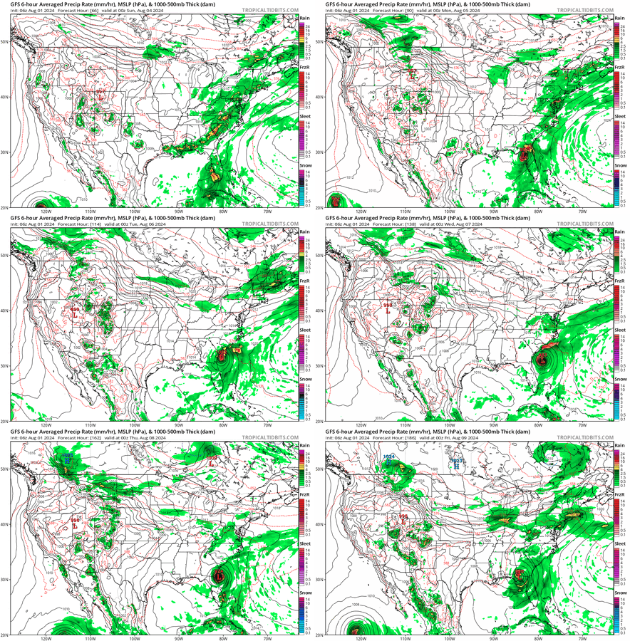
gfs_mslp_pcpn_frzn_us_fh66-186.gif
Any storm is unpredictable, but I'm hoping it don't do this.

The Euro takes a more measured approach starting on the west side of the state as well, exiting to the right into the atlantic and not using the Uno reverse card.
 
we got a direction y'all
1722515054586.png

Still not named.

But I want y'all to see this crazy model...its weird!

The GFS has done some crazy gymnastic loopdeloop stuff, crossing over to the Atlantic and exiting around Georgia and South Carolina, but being pushed back inland by the Bermuda High and coming back in about Jacksonville/St.Augustine area before being picked up by the high to go out again.

Basically this is what they're saying the currents will do as storms don't steer themselves.

The entire peninsula is getting rain from this system starting this weekend and into next week and it will be some decently heavy rains especially along South Florida , The Keys and west coast.

West coast, get ready, its gonna be big rains. Both models are showing Big Bend area as ground zero.
gfs_mslp_pcpn_frzn_us_fh66-186.gif
Any storm is unpredictable, but I'm hoping it don't do this.

The Euro takes a more measured approach starting on the west side of the state as well, exiting to the right into the atlantic and not using the Uno reverse card.

That's CRAZY!!
 
It gets even crazier!

Georgia, North and South Carolina, Virginia and DC areas are in the mix on this one depending on which model you're looking at.

Currently our little system is over Cuba. Still no name but its an invest so there's that at least. And at least there's model consensus as to where its going to start at.

This is the storm thats dumbfounding a lot of weather professionals. And its still crossing over Florida to the Atlantic but major models are having a difference of opinion as to what happens after it crosses. One model has it crossing as a sloppy mess and then forming in the Atlantic. The other has it forming close to Florida coast, then crossing and being a much stronger storm going up the coast.

In both cases, its saying there's a blocking Bermuda high and that means that the storm could sit and spin along the coast, or even just be dragged up the coast until it gets dragged out by another high.


1722605424849.png
54 counties in Florida are in the watch zone currently. We're getting some dribbles here in Palm Beach County and even though its sunny, its a weird looking sunny. Also yesterday was a hot that was indicative of a hurricane coming. (today its 88F before and feels like 103 before 10AM)

ZCZC MIATWOAT ALL
TTAA00 KNHC DDHHMM

Tropical Weather Outlook
NWS National Hurricane Center Miami FL
800 AM EDT Fri Aug 2 2024

For the North Atlantic...Caribbean Sea and the Gulf of Mexico:


1. A well-defined tropical wave is producing a large area of poorly
organized showers and thunderstorms over eastern Cuba, Hispaniola,
the southeastern Bahamas, and Jamaica, as well as the adjacent
waters of the southwestern Atlantic and the Caribbean Sea. The wave
is expected to move near or over Cuba throughout the day and then
emerge over the Straits of Florida tonight or Saturday.
Environmental conditions are expected to be conducive for additional
development after that time, and a tropical depression is likely to
form this weekend over the Straits of Florida or eastern Gulf of
Mexico near the Florida Peninsula. Tropical storm watches or
warnings could be required for portions of Florida later today.

Regardless of development, heavy rains could cause areas of flash
flooding across Florida, Cuba, and the Bahamas through the weekend,
and interests in these locations should continue to monitor the
progress of this system. A NOAA Hurricane Hunter aircraft is
scheduled to investigate this system later today.
* Formation chance through 48 hours...medium...60 percent.
* Formation chance through 7 days...high...90 percent.


Forecaster Beven
 
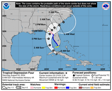
Tropical Depression 4 (we're getting bands from it right now)
094934_5day_cone_no_line_and_wind.png

There's some worry its going to be a bit more than a tropical storm. Its going to travel over some very warm water and the jet stream so, might strengthen before it comes on land.

When it gets to the Atlantic side its expected to be stronger. Nothing about this storm says falling apart over land.
 
Thanks for the updates @Arcadian, I'm on the coast in SC right now so watching this closely!
 
Thanks for the updates @Arcadian, I'm on the coast in SC right now so watching this closely!

I posted a new thread as this storm has been named. We're getting feeder bands in south florida which is something else.
 
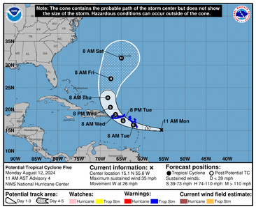
A new little something but by the looks of it modelwise, will not hit CONUS (those who may be Islands and Bermuda is gonna feel it though.

1723480157087.png
 
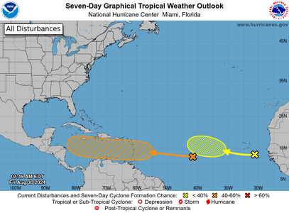
We may have a little something coming our way

1725025314629.png
 
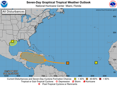
Southeast Texas there's a little something there which will be a basic low key depression. Does looks like Louisiana will be getting a little out of this too as it gets dragged by the low in the middle of the country.

Mr Orange is pingponging right now. No model agreement.

Ignoring that last yellow x...lol
1725127668397.png
 
:oops2: Hurricane Season Activated.
1725544936045.png
 
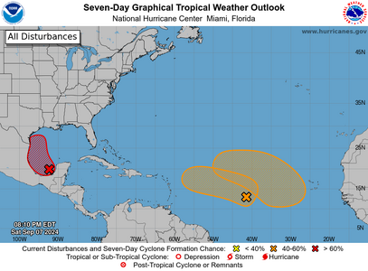
Texas and Louisiana needs to watch the red X If it gets a name I'll start a new thread. There's a lot of model agreement showing something is gonna form, there's small deviations as to where it will land though. GFS has been showing this for a while and its been spot on this year so its something to watch. Also GFS is showing something that could spin up in the NY/NJ and New England areas but that could change because of how far it is (September 18-20)
1725755751226.png
ZCZC MIATWOAT ALL
TTAA00 KNHC DDHHMM CCA

Tropical Weather Outlook...Corrected
NWS National Hurricane Center Miami FL
800 PM EDT Sat Sep 7 2024

Corrected typo in the second disturbance paragraph.

For the North Atlantic...Caribbean Sea and the Gulf of Mexico:

1. Western Gulf of Mexico (AL91):
An area of low pressure located over the Bay of Campeche is
producing disorganized showers and thunderstorms. This disturbance
is forecast to drift slowly northward during the next several days
while it interacts with a frontal boundary. Environmental conditions
are forecast to become more conducive for development, and a
tropical depression is likely to form while the system moves
generally northward near or along the Gulf coast of Mexico and Texas
through the middle of next week. Interests along the western Gulf of
Mexico coast should closely monitor the progress of this system.
* Formation chance through 48 hours...medium...60 percent.
* Formation chance through 7 days...high...80 percent.

2. Central Tropical Atlantic:
Shower and thunderstorm activity associated with an area of low
pressure over the central tropical Atlantic has begun to show signs
of organization. Gradual additional development is possible, and a
tropical depression could form while the system meanders over the
central tropical Atlantic through Monday and then moves generally
westward at about 10 mph through the rest of next week.
* Formation chance through 48 hours...low...30 percent.
* Formation chance through 7 days...medium...50 percent.

3. Eastern and Central Tropical Atlantic:
Disorganized showers and thunderstorms associated with a trough of
low pressure are located several hundred miles southwest of
the Cabo Verde Islands. The disturbance is expected to move very
little during the next few days until it potentially interacts with
a tropical wave that is forecast to move off the west coast of
Africa by early Monday. Environmental conditions are expected to be
favorable for gradual development of this system, and a tropical
depression could form by the middle or late portions of next week.
The system is expected to begin moving slowly westward by the end
of the week.
* Formation chance through 48 hours...low...near 0 percent.
* Formation chance through 7 days...medium...40 percent.


Forecaster D. Zelinsky

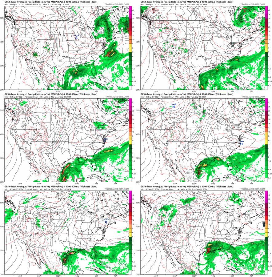
GFS Showing out to hour 114 that there is a possible low grade storm that will hit somewhere in the gulf.
 
Last edited:
Had a real, true thunderstorm roll through about a month ago. Not violent for most of the states, but about a once-in-a-decade storm for here! The barometric pressure change also got my fish to finally breed, so I think it’s a good thing.
 
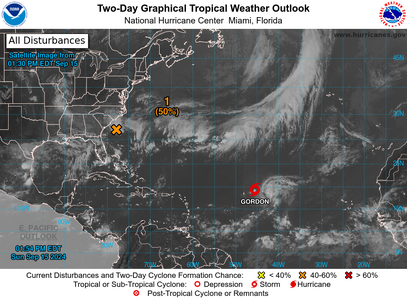
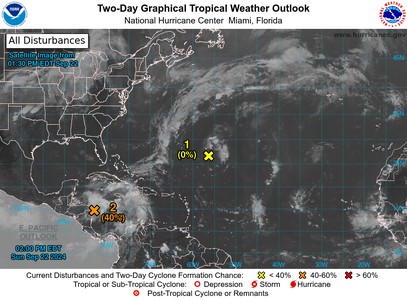
Gordon isn't anything to worry about but that orange x is (Models have it developing)
1726427292689.png


The thought is that it won't be too strong, but will bring in a lot of rain and gusty winds to the area. From the models I've seen will move into SC and go out of NC /Virginia


TTAA00 KNHC DDHHMM

Tropical Weather Outlook
NWS National Hurricane Center Miami FL
200 PM EDT Sun Sep 15 2024

For the North Atlantic...Caribbean Sea and the Gulf of Mexico:

Active Systems:
The National Hurricane Center is issuing advisories on Tropical
Storm Gordon, located over the central tropical Atlantic Ocean.

1. Offshore the Southeastern U.S. Coast (AL95):
A non-tropical low pressure area is located along a frontal
boundary a couple of hundred miles off the southeastern U.S. coast,
and is producing winds to gale force north of its center. The low
is forecast to move northwestward or northward over the warm waters
of the Gulf Stream toward the coasts of North Carolina and South
Carolina, and it could become a subtropical or tropical storm during
the next day or so if the associated front dissipates and showers
and thunderstorms become sufficiently organized. An Air Force
Hurricane Hunter aircraft is currently investigating the system.

Regardless of tropical or subtropical development, the low is
likely to bring gusty winds, heavy rains with the potential for
flash flooding, coastal flooding, and dangerous beach conditions to
portions of the U.S. Southeast and Mid-Atlantic coast during the
next couple of days, and interests in these areas should monitor
the system's progress. Additional information can be found in
products issued by your local National Weather Service Forecast
Office and High Seas Forecasts issued by the National Weather
Service.
* Formation chance through 48 hours...medium...50 percent.
* Formation chance through 7 days...medium...50 percent.


High Seas Forecasts issued by the National Weather Service can be
found under AWIPS header NFDHSFAT1, WMO header FZNT01 KWBC, and
online at ocean.weather.gov/shtml/NFDHSFAT1.php

Forecaster Pasch
 
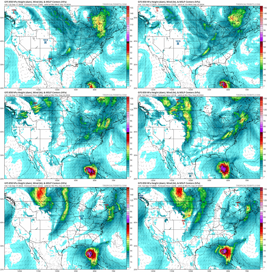
According to the models (if they're correct), Florida will be getting something very unpleasant in the next 10 days. nothing is official yet. I keep hoping its not gonna be true. (this is what I hate about hurricane season)

And while this is one model run, they're all showing something which means there's a high enough confidence of when not if, its a matter of where.

gfs_mslp_uv850_us_fh186-228.gif
 
Well

1727030233061.png

we have a juicy CAG This is a good place to understand what that is. https://weather.com/storms/hurricane/news/2024-06-14-central-american-gyre-explained

Nasty storms have formed from this area and popped us. Anyway, there's really nothing yet, just an X and some clouds, but its a known area for storms that can rapidly intensify if they don't move fast enough though those warm gulf waters. Local news is watching it pretty close where I am, lots of things depend on the high and the and the front coming through mid week.

From what I've seen modeling is everywhere because nothing has formed yet, but looks to be ending up where Michael was (if you want to know how nasty Michael was click here) Michael was a monster of a storm, felt all over the state in more ways than one! We didn't have as bad effects as the west side for sure, still it was a big enough storm that we got TS force gusts nasty surf and bad weather.

When this storm forms I'll have a thread with its own name.


If anyone is interested, this is what NHC is saying:

2. Northwestern Caribbean Sea and Gulf of Mexico:
Disorganized showers and thunderstorms located over the northwestern
Caribbean Sea and portions of Central America are associated with a
broad area of low pressure. Environmental conditions appear
favorable for development of this system, and a tropical depression
or tropical storm is likely to form during the next few days while
moving northward across the northwestern Caribbean Sea and Gulf of
Mexico. Regardless of development, this disturbance is expected to
produce heavy rains over portions of Central America during the next
several days. Interests in the northwestern Caribbean, Yucatan
Peninsula of Mexico, and western Cuba should closely monitor the
progress of this feature. Later this week, the system is forecast to
move generally northward across the Gulf of Mexico, and interests
along the northern and northeastern Gulf Coast should also monitor
the progress of this system.
* Formation chance through 48 hours...medium...40 percent.
* Formation chance through 7 days...high...80 percent.
 
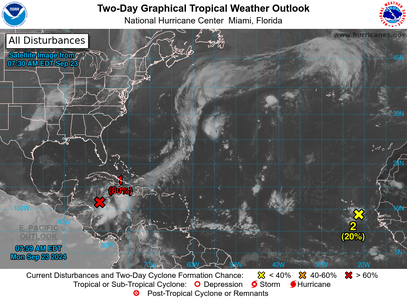
OK. There might be a name today or tomorrow on the red x. I can't lie, I'm worried.

1727096195976.png
 
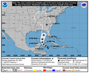
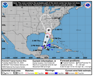
Now there's a cone. Hurricane hunters are enroute to find out whats going on https://www.tropicaltidbits.com/recon/

Anyone flying in and out of Florida, Alabama, Mississippi, Georgia, South Carolina needs to check airlines for cancellation status.


1727104804088.png
 
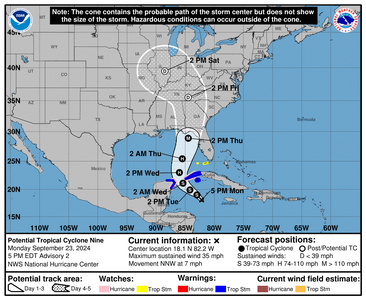
Not named yet but Hurricane Hunters are out there update to the track. The wording in the discussion is worrisome. The model data is worrisome.

1727126754088.png

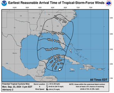
If the current track holds winds into Florida will begin Tuesday night/Wednesday morning.
1727127528656.png

845
WTNT44 KNHC 232053
TCDAT4

Potential Tropical Cyclone Nine Discussion Number 2
NWS National Hurricane Center Miami FL AL092024
500 PM EDT Mon Sep 23 2024

Showers and thunderstorms associated with the disturbance are
gradually becoming better organized this afternoon, although the
convection is mostly confined to the eastern portion of the
circulation. Scatterometer winds and aircraft data indicate the
disturbance still lacks a well-defined center, with very light winds
noted on the west side of the broad, elongated circulation. The
scatterometer data did show stronger winds near the convection on
the east side, and based on this along with the aircraft winds, the
initial intensity is raised to 30 kt for this advisory.

The estimated initial motion is north-northwestward (345/6 kt), but
the disturbance should turn more northwestward during the next day
or so. The NHC forecast shows the center of the system passing
between the Yucatan Peninsula and the western tip of Cuba late
Tuesday night, then moving into the southern Gulf of Mexico on
Wednesday. From there, the flow between a deep-layer trough over the
central United States and a ridge over the western Atlantic should
cause the system to accelerate northward to north-northeastward
across the eastern Gulf of Mexico and toward the northeastern Gulf
Coast and Florida Panhandle through Thursday. The track guidance is
very tightly clustered on this solution, and the official NHC
forecast is essentially an update of the previous one.

The moderate southwesterly shear over the disturbance is expected to
diminish over the next day or two, which should allow the system to
become better organized and consolidate over deep, warm waters in a
very moist environment. Once the system develops an inner core,
these conditions should allow it to significantly strengthen. The
NHC forecast still calls for the system to become a hurricane on
Wednesday, with continued intensification thereafter while it moves
over the eastern Gulf of Mexico. Once again, the statistical RI
guidance (SHIPS and DTOPS) show a 65-kt increase in 72 h is very
likely, and the updated NHC forecast now explicitly shows the system
reaching major hurricane intensity on Thursday. This intensity
forecast still lies below the consensus aids, with the regional
hurricane models and the GFS showing even more deepening.

Note that the system is expected to grow in size while it traverses
the Gulf. Thus, the storm surge, wind, and rainfall impacts will
extend well away from the center, particularly to the east of the
system. In addition, the fast forward speed as it approaches the
coast will likely result in farther inland penetration of gusty
winds over parts of the southeastern United States after landfall.


KEY MESSAGES:

1. The disturbance is forecast to intensify and be near hurricane
strength when it reaches the far northwestern Caribbean Sea Tuesday
night. Tropical storm conditions are expected over portions of
western Cuba and the northeastern coast of the Yucatan Peninsula
with hurricane conditions possible.

2. The system is expected to intensify into a major hurricane
before it approaches the northeastern Gulf Coast on Thursday. While
it is too soon to pinpoint the exact location and magnitude of
impacts, the potential for life-threatening storm surge and
damaging hurricane-force winds along the coast of the Florida
Panhandle and the Florida west coast is increasing. Storm Surge
and Hurricane Watches will likely be issued for a portion of that
area tonight or Tuesday morning, and residents should ensure they
have their hurricane plan in place.

3. Potential Tropical Cyclone Nine will bring heavy rain to portions
of the western Caribbean which may lead to flooding and possible
mudslides in western Cuba.


FORECAST POSITIONS AND MAX WINDS

INIT 23/2100Z 18.1N 82.2W 30 KT 35 MPH...POTENTIAL TROP CYCLONE
12H 24/0600Z 19.0N 83.0W 35 KT 40 MPH...TROPICAL CYCLONE
24H 24/1800Z 19.9N 84.2W 45 KT 50 MPH
36H 25/0600Z 21.1N 85.4W 55 KT 65 MPH
48H 25/1800Z 23.0N 86.0W 75 KT 85 MPH
60H 26/0600Z 25.4N 85.5W 90 KT 105 MPH
72H 26/1800Z 28.9N 84.5W 100 KT 115 MPH
96H 27/1800Z 35.5N 84.5W 30 KT 35 MPH...POST-TROP/INLAND
120H 28/1800Z 39.5N 88.5W 20 KT 25 MPH...POST-TROP/INLAND

$$
Forecaster Reinhart
 
We're getting rain bands in South Florida.

1727183579115.png


"Due to the forecast large size of this system, storm surge, wind,
and rainfall impacts will extend well away from the center,
particularly on the east side. In addition, the fast
forward speed while it crosses the coast will likely result in
farther inland penetration of strong winds over parts of the
southeastern United States after landfall. Hurricane and Storm
Surge Watches have been issued this morning, and further watches
and warnings are likely later today.
"
 
Hurricane season is not over (not until November 30)

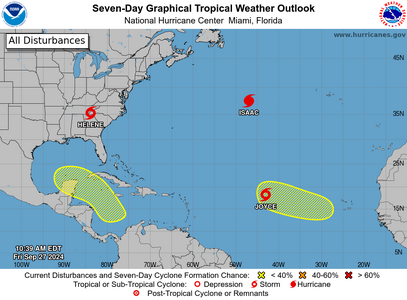
1727451270175.png
 
1727566152722.png

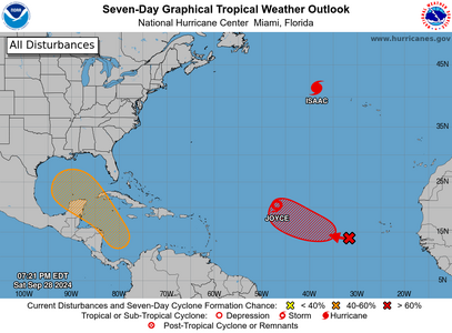
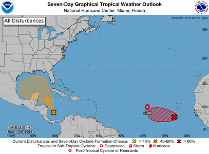
This orange one is showing possible development.
 
1727792570242.png

Kirk is possibly staying out to sea but it will be a major storm.

The storm that might be worth watching for the US is whats in orange as it could be anything from a rainstorm to another hurricane. Not enough model guidance on whats forming.

Anything thats bringing rain at this point though can be a hard pill to swallow for many. If it gets named I will create a new thread.
 
1728089944080.png


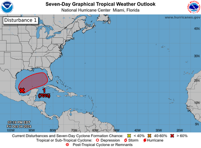
looks like we may have something going on and looking to come ashore in the middle of the Florida peninsula

1. Gulf of Mexico:
A broad area of low pressure located over the southwestern Gulf of
Mexico is producing disorganized showers and thunderstorms.
Gradual development of this system is expected, and a tropical or
subtropical depression or storm is likely to form late this weekend
or early next week while the system moves eastward or northeastward
across the Gulf of Mexico. Interests in the Florida Peninsula and
the Florida Keys should monitor the progress of this system.
Regardless of tropical or subtropical development, locally heavy
rains could occur over portions of Mexico during the next day or
two, and over much of Florida late this weekend through the middle
of next week.
* Formation chance through 48 hours...low...30 percent.
* Formation chance through 7 days...high...70 percent.
 
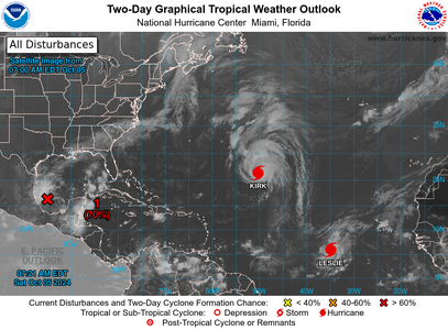
Florida people, this does not look good. I'm talking about our red X. Model agreement on these storms so probably next will be M named. couple of scenarios; could either go north of me, in which case will be a major storm. could stay south and cross over my house and be a weaker storm, tropical to cat 1ish. either way lots of rain with this.

Consensus I'm seeing: prep like its a hurricane.

1728131873746.png


1. Gulf of Mexico (AL92):
Showers and thunderstorms associated with a broad area of low
pressure located over the southwestern Gulf of Mexico are gradually
becoming better organized. Development of this system is expected,
and a tropical depression or storm is likely to form later today or
on Sunday while it moves slowly eastward over the southwestern Gulf
of Mexico. By early next week, the system is forecast to move
faster eastward or northeastward across the central and eastern Gulf
of Mexico where additional strengthening is likely. Interests on
the Yucatan peninsula of Mexico, the Florida Peninsula, the Florida
Keys, and the northwestern Bahamas should monitor the progress of
this system. Regardless of development, locally heavy rains could
occur over portions of Mexico during the next day or two, and over
much of Florida late this weekend through the middle of next week.

* Formation chance through 48 hours...high...70 percent.
* Formation chance through 7 days...high...90 percent.
 
NHC will do an update at 10AM CDT Their messaging:

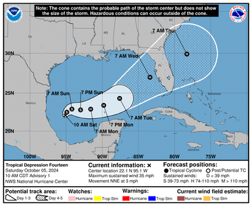
NHC will initiate advisories on Tropical Depression Fourteen, located over the southwestern Gulf of Mexico, at 1000 AM CDT (1500 UTC)
 
We have TD 14
1728147736710.png


000
WTNT44 KNHC 051459
TCDAT4

Tropical Depression Fourteen Discussion Number 1
NWS National Hurricane Center Miami FL AL142024
1000 AM CDT Sat Oct 05 2024

Early morning one-minute GOES-East satellite imagery shows that the
circulation associated with the area of low pressure over the
southwestern Gulf of Mexico has become better defined. Deep
convection has been persistent over the northwestern portion of the
circulation with some increase in banding also noted. Based on the
recent increase in organization, advisories are being initiated on
Tropical Depression Fourteen. The initial intensity is set at 30
kt which is supported by overnight ASCAT data. Another ASCAT pass
is expected over the system later this morning.

The depression is moving north-northeastward or 025/3 kt. The
system is forecast to drift northeastward or east-northeastward
during the next day or so. After that time, a trough moving
southward over the northwestern Gulf of Mexico is expected to cause
the system to turn east-northeastward to northeastward at a
slightly faster forward speed. By Tuesday the cyclone is expected
to move northeastward at an increasingly faster forward speed and
this track will bring the system across the west coast of the
Florida Peninsula by midweek.
The track guidance is in good
agreement on this overall scenario, but there are differences in
the forward speed. The NHC track lies near the various consensus
aids, but it slightly faster since the typically reliable GFS and
ECMWF global models are on the faster side of the guidance. Users
are reminded to not focus on the exact forecast track or timing at
the longer range as the average NHC 4-day track error is about 150
miles.


The depression is within a favorable environment of low vertical
wind shear and warm sea surface temperatures. These conditions are
expected to allow for steady to rapid strengthening over the next
few days. The intensification is likely to be slower during the
next 12 to 24 hours until an inner core can become established, but
after that time a faster rate of strengthening is anticipated.
The
global models predicted significant deepening when the system moves
across the central and eastern Gulf of Mexico and the regional
hurricane models show the potential for rapid strengthening during
that time. The NHC forecast follows suit and calls for a period of
rapid intensification after 36 h. The official forecast shows
the system nearing major hurricane strength over the central and
eastern Gulf of Mexico. This forecast is near the intensity
consensus aids but some upward adjustment may be required as it lies
a little below the regional hurricane models. Regardless of the
exact details of the intensity forecast, an intense hurricane with
multiple life-threatening hazards is likely to affect the west coast
of the Florida Peninsula next week.


Key Messages:
1. The depression is forecast to quickly intensify while it moves
eastward to northeastward across the Gulf of Mexico and be at or
near major hurricane strength when it reaches the west coast of the
Florida Peninsula mid week.

2. There is an increasing risk of life-threatening storm surge and
wind impacts for portions of the west coast of the Florida
Peninsula beginning late Tuesday or Wednesday. Residents in these
areas should ensure they have their hurricane plan in place, follow
any advice given by local officials, and check back for updates to
the forecast.

3. Areas of heavy rainfall will impact portions of Florida Sunday
and Monday well ahead of the tropical system, with heavy rainfall
more directly related to the system expected by later Tuesday
through Wednesday. This rainfall brings the risk of flash, urban,
and areal flooding, along with minor to isolated moderate river
flooding.


FORECAST POSITIONS AND MAX WINDS

INIT 05/1500Z 22.1N 95.1W 30 KT 35 MPH
12H 06/0000Z 22.5N 94.9W 35 KT 40 MPH
24H 06/1200Z 22.9N 94.2W 45 KT 50 MPH
36H 07/0000Z 22.8N 93.0W 55 KT 65 MPH
48H 07/1200Z 22.9N 91.6W 70 KT 80 MPH
60H 08/0000Z 23.4N 89.8W 85 KT 100 MPH
72H 08/1200Z 24.3N 87.6W 95 KT 110 MPH
96H 09/1200Z 27.0N 83.4W 95 KT 110 MPH

120H 10/1200Z 29.9N 78.3W 65 KT 75 MPH

$$
Forecaster Brown
 
Don't hate me
1728857779523.png

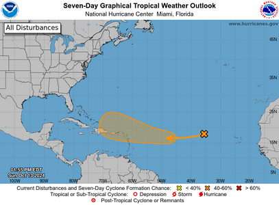
Models don't have it going anywhere near Florida from what I can tell but one never knows with this crazy season.
 
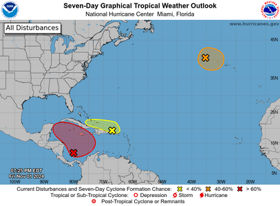
Hurricane season is not over folks. we got some spots.
two_atl_7d011-1-2024.png
 
Hurricane season is not over folks. we got some spots.
two_atl_7d011-1-2024.png

It seems hurricane season bleeds into November now. I wish it would quit doing that
 
It seems hurricane season bleeds into November now. I wish it would quit doing that

Officially it ends November 30. Because of the warmer ocean waters we get more violent storms. In December we can get some interesting no name stuff.
 
GET 3 FREE HCA RESULTS JOIN THE FORUM. ASK FOR HELP
Top