shape
carat
color
clarity

Hurricane Lee

Arcadian

Ideal_Rock
Premium
Joined
Sep 17, 2008
Messages
9,390
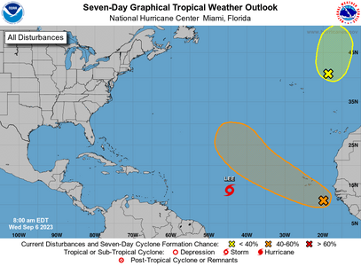
Its going to be a hurricane so I'm going to call it one now...

I keep seeing a trend west. I wasn't going to even put this out there but some model runs are making some suggestions of a CONUS scrape.

And Lee is on tap to become a major hurricane.

Some model members had it going into North Carolina and riding the coast. Some had it going into New England, riding up the coast. And still some have missing CONUS altogether.

083846_5day_cone_no_line_and_wind.png


000
WTNT43 KNHC 060837
TCDAT3

Tropical Storm Lee Discussion Number 4
NWS National Hurricane Center Miami FL AL132023
500 AM AST Wed Sep 06 2023

Lee continues to strengthen at a quick pace. Satellite images show
that deep convection has been increasing in intensity and coverage
in a central dense overcast feature and in a sprawling curved band
over the western semicircle. The Dvorak classifications from TAFB
and SAB are now 3.5/55 kt, and accordingly, the initial intensity
has been increased to 55 kt. Lee is not far from hurricane
strength, and it likely will achieve that status later today.

The tropical storm is moving west-northwestward at 14 kt on the
south side of a subtropical ridge over the central Atlantic. This
ridge is expected to persist to the north of Lee during the next
several days, keeping the storm on a west-northwest track through
the remainder of the week and over the weekend. Although the NHC
forecast and the model guidance continue to show Lee passing to the
north of the northern Leeward Islands this weekend, users are
reminded that the details of the track forecast are still uncertain
at those time ranges. For reference, the average NHC forecast track
errors are around 125 and 175 n mi on days 4 and 5, respectively.
The NHC track forecast lies on the southern side of the model
guidance envelope, roughly halfway between the usually most skillful
consensus aids, HCCA and TVCA.


Lee has already been strengthening fairly quickly despite some
east-northeasterly vertical wind shear over the system. Since the
shear is expected to relax while the storm remains over very warm
water and in a moist environment, continued steady to rapid
intensification is expected during the next few days. Most of the
intensity models are very aggressive, bringing Lee to major
hurricane status by the weekend, but they don't show much change in
strength in the short term. In addition, even the global models
like the GFS and ECMWF show explosive intensification and forecast
Lee's minimum pressure to drop by more than 60 mb by the end of the
forecast period. The NHC intensity forecast lies near the high end
of the model guidance during the next 24-48 hours, but falls to near
the middle of the guidance envelope after that. Regardless of the
details, there is high confidence that Lee will be a powerful
hurricane late this week and over the weekend.

KEY MESSAGES:

1. Lee is forecast to become a major hurricane by late this week and
could bring impacts to the Leeward Islands this weekend. While it is
too soon to determine the location and magnitude of these possible
impacts, interests in this area should monitor the progress of Lee
and further updates to the forecast.


FORECAST POSITIONS AND MAX WINDS

INIT 06/0900Z 13.7N 44.6W 55 KT 65 MPH
12H 06/1800Z 14.3N 46.4W 70 KT 80 MPH
24H 07/0600Z 15.1N 48.8W 80 KT 90 MPH
36H 07/1800Z 16.0N 51.3W 90 KT 105 MPH
48H 08/0600Z 17.0N 53.7W 105 KT 120 MPH
60H 08/1800Z 18.1N 56.2W 120 KT 140 MPH
72H 09/0600Z 19.2N 58.4W 130 KT 150 MPH
96H 10/0600Z 21.1N 62.4W 130 KT 150 MPH
120H 11/0600Z 22.7N 65.5W 130 KT 150 MPH

$$
Forecaster Cangialosi
 

Attachments

  • 1694008772787.png
    1694008772787.png
    59.3 KB · Views: 2
Fingers crossed that it turns north and misses ALL of the East Coast! In the meantime, I'll be paying attention:oops2:

BTW, as I was typing this I think* I just heard its already turned into a hurricane. I'm off to investigate!

Edit...Accuweather said it may get close to a Level 5 hurricane. Southeast should not have to worry but those
from the Outer Banks on thru Nova Scotia could be at issue. There is a low front that may hold it off the US coast
but if the low front doesn't move far enough East then it may not hold Lee off the US coast.

All ya'll on the NorthEast coast from the Outer Banks on up need to pay attention to what happens with Lee.
 
Last edited:
Fingers crossed that it turns north and misses ALL of the East Coast! In the meantime, I'll be paying attention:oops2:

BTW, as I was typing this I think* I just heard its already turned into a hurricane. I'm off to investigate!

Edit...Accuweather said it may get close to a Level 5 hurricane. Southeast should not have to worry but those
from the Outer Banks on thru Nova Scotia could be at issue. There is a low front that may hold it off the US coast
but if the low front doesn't move far enough East then it may not hold Lee off the US coast.

All ya'll on the NorthEast coast from the Outer Banks on up need to pay attention to what happens with Lee.
Yep I saw this model run a few days ago and I gulped. It was a very big storm. but I didn't want to be an alarmist considering I'm not a professional.

But yeah I saw it hit 914mb on a few runs and my heart sunk. Thats A Dorian type of storm.
 
Things can change, boy can they change And there will be more changes because there's no real consensus after the current 7 day cone. What I'm telling you goes beyond 7 days, so it will change. However you got folks and news channels already freaking out because of the last storm. (this is common, they do this every freaking time)

Last Euro Model run and its beating the crap out of the NE going into Nova Scotia. That was around September 14-16. Just know that its only 1 model run and it is not a done deal because while patterns are emerging there's no agreement.

Models this far out will change. The storm can slow down, or speed up based on model runs. All kinds of things can happen this far out.

That said, New England/Mid Atlantic states/Nova Scotia and Bermuda should be paying very close attention. however, don't panic, but do have some plans in place.
 
Lived through my share of weather events in Houston and don’t care to go through them in the NE, but, Mother Nature has her own way.

Fellow Houstonians probably know the site spacecityweather. They are two meterelogists who started a no-hype blog and they have been nothing short of amazing in describing patterns, uncertainty and telling you when it’s hype or when to seriously prepare. They recently expanded their site to cover more nationwide events including Lee. Their new site is https://theeyewall.com/. They are also on Twitter.

Fingers crossed Lee ends up being a fish storm.
 
Lee will clip somebody and there's really no such thing as a fish storm with all the inhabited islands out there.

Its not a term I like to use because of that fact.

1694175612529.png

Lee is a Cat 5 right now. And so far hasn't hit anything. It will be near the Leewards this weekend, Puerto Rico late Sunday /early Monday but the latest models.

Air Recons will be taking place probably pretty often https://www.tropicaltidbits.com/recon/

1694175816773.png


Still lots of uncertainty past the latest track. There's supposed go north f you go by all the models and its still there now. What happens is pretty interesting though. Lee pulls a Dorian and slows down because the weak steering currents. Lee will also increase in size.

Once it gets pulled north again, its uncertain where that will happen. I always says this, bad weather happens outside the eye. If the storm is 5-600 miles wide, thats how big the storm is and everything in its path, not just the eye, gets that weather.

Past Tuesday, there's not a lot of certainty where things will go, please remember that but also continue to watch.

A lot is riding on the high being able to move in quick enough, and this far out its just an unknown.

788

WTNT43 KNHC 080839
TCDAT3

Hurricane Lee Discussion Number 12
NWS National Hurricane Center Miami FL AL132023
500 AM AST Fri Sep 08 2023

Lee remains an extremely powerful category 5 hurricane. Satellite
images indicate that Lee has a symmetric inner core with a 10 n mi
circular and clear eye and no indications of concentric eyewalls
forming yet. Although the hurricane is incredibly powerful, its
wind field is not particularly large with its tropical-storm-force
winds extending roughly 100 n mi from the center.
The Air Force
Hurricane Hunters investigated Lee earlier this morning and found
that the pressure has fallen to about 926 mb, based on dropsonde
data. In addition, the maximum 700-mb flight-level wind reported
was 153 kt and maximum surface SFMR wind was 158 kt, but this
estimate could be inflated. Blending these measurements, the
initial wind speed is nudged upward to 145 kt. Both the NOAA and
Air Force Hurricane Hunters will further investigate Lee in a couple
of hours.

Since Lee is expected to remain in favorable atmospheric conditions
while moving over even warmer waters during the next couple of days,
it seems likely that the hurricane will at least maintain its
intensity or become a little stronger during that time. The
dominant factor for Lee's short term intensity will be internal
dynamics, like eyewall replacement cycles. These conditions will
often cause fluctuations in the hurricane's strength, which are
challenging to forecast.
There likely will be some weakening beyond
a few days when Lee moves over somewhat cooler waters and into an
environment of slightly higher shear. Regardless of the details,
Lee is expected to remain a powerful hurricane during the next
several days.

The major hurricane has been on a steady west-northwest path during
the past couple of days as it has been steered by the flow on the
south side of a subtropical ridge over the central Atlantic. A
continued west-northwest motion is expected, but at a progressively
slower pace during the forecast period as the ridge to the north of
the system weakens. The models are in fairly good agreement, and
little change was made to the previous NHC track forecast.

Lee is expected to increase in size and become more symmetric over
the weekend and early next week as the hurricane slows down.
Recent
wave altimeter data showed peak significant wave heights between 45
and 50 feet near the center. Dangerously high seas are expected to
continue near the core of the hurricane, and large swells will
spread well away from the system through the forecast period.


KEY MESSAGES:

1. Lee is a dangerous category 5 hurricane, and further
strengthening is possible. Lee's core is expected to move well
north of the northern Leeward Islands, the Virgin Islands, and
Puerto Rico this weekend and early next week.

2. Dangerous surf and life-threatening rip currents are likely in
the northern Leeward Islands beginning later today. These
conditions will spread westward and northward, affecting Puerto
Rico, Hispaniola, the Turks and Caicos, the Bahamas, and Bermuda
through the weekend.

3. It is way too soon to know what level of impacts, if any, Lee
might have along the U.S. East Coast, Atlantic Canada, or Bermuda
late next week, particularly since the hurricane is expected to
slow down considerably over the southwestern Atlantic. Regardless,
dangerous surf and rip currents are expected along most of the U.S.
East Coast beginning Sunday. Continue to monitor updates to Lee's
forecast during the next several days.


FORECAST POSITIONS AND MAX WINDS

INIT 08/0900Z 17.8N 53.5W 145 KT 165 MPH
12H 08/1800Z 18.6N 55.1W 155 KT 180 MPH<---thats crazy to me!
24H 09/0600Z 19.6N 57.1W 150 KT 175 MPH
36H 09/1800Z 20.5N 58.8W 145 KT 165 MPH
48H 10/0600Z 21.2N 60.2W 145 KT 165 MPH
60H 10/1800Z 21.9N 61.5W 140 KT 160 MPH
72H 11/0600Z 22.4N 62.7W 135 KT 155 MPH
96H 12/0600Z 23.3N 65.1W 130 KT 150 MPH
120H 13/0600Z 24.4N 67.1W 120 KT 140 MPH

$$
Forecaster Cangialosi
 
Current changes Key Message number 3 is very important. Basically don't panic, just watch.


076
WTNT43 KNHC 082040
TCDAT3

Hurricane Lee Discussion Number 14
NWS National Hurricane Center Miami FL AL132023
500 PM AST Fri Sep 08 2023

The small eye of Lee has become cloud filled this afternoon.
A 1643 UTC AMSR2 microwave overpass and the earlier reconnaissance
aircraft reports indicate that Lee's eye was a little less than
10 n mi in diameter. The microwave imagery revealed a well-defined
inner core but there was a lack of banding noted just outside the
core. This is likely due to some drier mid-level air that has
wrapped into the circulation. The Air Force Reserve Hurricane
Hunter aircraft did not find any stronger flight-level or SFMR winds
after the release of the previous advisory, and the initial
intensity for this advisory has been set at 130 kt
. This is a blend
of the earlier reconnaissance data and subjective Dvorak intensity
estimates of T6.5 or 127 kt from TAFB and SAB. NOAA and Air Force
reconnaissance aircraft are scheduled to investigate Lee again this
evening.

The moderate shear and dry mid-level air that has affected Lee
today is not expected to abate during the next 12-24 hours. After
that time, the upper-level wind pattern could become a little more
conducive for re-strengthening. However, the timing of eyewall
replacement cycles makes it difficult to predict when Lee might
re-intensify. Although there is lower-than-normal confidence in
the exact details of the intensity forecast, there is high
confidence that Lee will remain a powerful hurricane into early next
week
. The latest NHC wind speed forecast is a blend of the HFIP
corrected consensus model and the multi-model intensity consensus
aids.

Lee continues to move west-northwestward or 300 degrees at 11 kt.
A well-established mid- to upper-level ridge over the central
Atlantic should continue to steer the hurricane west-northward into
early next week. The ridge is forecast to build southwestward near
Bermuda late this weekend and early next week which is expected
cause Lee's forward speed to slow around 5-7 kt between days 2-4.
Late in the period, a mid-latitude trough that will be moving into
the Great Lakes Region is forecast to weaken the western portion of
the ridge, and Lee should begin to turn more poleward around that
time. The track guidance is still in good agreement through about
72 hours, but there is slightly more spread at days 4 and 5.

The spread is primarily related to speed differences in the guidance
during the latter portion of the forecast period. The latest NHC
track prediction is again close to the HCCA and TCVA consensus
aids, and it is very similar to the previous official forecast.


KEY MESSAGES:

1. Lee's core is expected to move well north of the northern
Leeward Islands, the Virgin Islands, and Puerto Rico this weekend
and early next week.

2. Dangerous surf and life-threatening rip currents are affecting
portions of the northern Leeward Islands. These conditions
will spread westward and northward, affecting Puerto Rico,
Hispaniola, the Turks and Caicos, the Bahamas, and Bermuda
through the weekend.

3. It is way too soon to know what level of impacts, if any, Lee
might have along the U.S. East Coast, Atlantic Canada, or Bermuda
late next week, particularly since the hurricane is expected to
slow down considerably over the southwestern Atlantic. Regardless,
dangerous surf and rip currents are expected along most of the U.S.
East Coast beginning Sunday and Monday. Continue to monitor

updates to Lee's forecast during the next several days.


FORECAST POSITIONS AND MAX WINDS

INIT 08/2100Z 18.9N 55.5W 130 KT 150 MPH
12H 09/0600Z 19.7N 56.9W 125 KT 145 MPH
24H 09/1800Z 20.6N 58.6W 120 KT 140 MPH
36H 10/0600Z 21.3N 60.0W 120 KT 140 MPH
48H 10/1800Z 21.9N 61.3W 125 KT 145 MPH
60H 11/0600Z 22.5N 62.5W 125 KT 145 MPH
72H 11/1800Z 23.0N 63.7W 125 KT 145 MPH
96H 12/1800Z 23.7N 66.0W 120 KT 140 MPH
120H 13/1800Z 25.1N 67.6W 110 KT 125 MPH

$$
Forecaster Brown
 
I apologize. Some meteorologists refer storms that go out to see as fish storms and I did not realize there is no such thing.
 
I apologize. Some meteorologists refer storms that go out to see as fish storms and I did not realize there is no such thing.

Well, fascinatingly storms that rain fish, frogs etc. do happen, though rare.
But you're right, meteorologists' adopting the term 'fish storm' for hurricanes that dissipate out over the ocean is a misnomer ...

(NEXSTAR/WFLA) – The National Hurricane Center reported a new disturbance in the Atlantic on Friday, explaining in its outlook that an area of low pressure “located well east of Bermuda” had produced sustained winds of 40 mph and limited showers over the ocean.

It’s unlikely the disturbance will develop into a tropical cyclone in the coming days (chances are currently estimated at 10%, according to the NHC), but there’s a possibility it could pick up “subtropical or tropical characteristics” as it makes its way toward the northwestern Atlantic, the outlook predicted. Even if it does, the NHC said as of Saturday that the storm is unlikely to develop before hitting land.

In other words, it’s likely just a “fish storm,” according to Jeff Berardelli, the chief meteorologist at Nexstar’s WFLA.

Meteorologists sometimes use the term “fish storm” to refer to a storm that generally poses no risk to land. But these storms may still pose a threat to fishing boats or shipping routes, and the National Weather Service continues to issue reports on such weather systems in its High Seas Forecasts.

Occasionally, “fish storms” may also produce possible dangerous currents along the coasts. In 2021, for instance, Tropical Storm Odette actually moved away from the U.S. Mid-Atlantic region but meteorologists (including those at Nexstar’s WSAV) warned of possible rip currents nonetheless.

As it stands, however, the current disturbance in the Atlantic is too far off, and too weak, to pose much of a threat at all. The NHC estimates it will arrive in colder northwestern Atlantic waters by the middle of next week, at which point it would have even less chance of development.

“Even if it were to form it is already decently far north and will likely only gain latitude over the coming days,” said WFLA’s Berardelli. “Lastly, this time of year fronts come along so frequently that the system would have a very hard time making it all the way to the East Coast of the US. So this is most likely destined to be a fish storm.”

Source for the above:


Then ...

wiki.png
 
I apologize. Some meteorologists refer storms that go out to see as fish storms and I did not realize there is no such thing.

Its not you, its a term that gets my hackles up because it gets used in such a blase fashion. Many of these storms, even if they don't hit large land masses like the US, can impact someone, and too many figure oh, I'm OK so fish storm. No, unfortunately there are inhabited islands out there that while they don't get a lot of press, do get impacted.

The impacts to CONU for the most part is going to be very high surf. Those on the immediate coast will feel those effects pretty heavily and I don't doubt there will be some beach erosion from this.

Depending on where the track goes and how close it is to mainland CONUS when it reaches close the NE, Martha's Vinyard and especially Nantucket could be affected heavily.

Bermuda will absolutely be impacted by Lee considering its size and from where I've seen the tracks go, and I would not exactly call them fish.

In addition, Lee is going to affect Nova Scotia if the track holds true (it could make landfall there) and I don't consider them fish either.

And @kenny while there are fish storms, i.e., fish that get swept up in storms and deposited somewhere else, the venacular to use it during hurricane season, especially with very little disregard for islanders, is classist, particularly when many of these islanders tend to be black or minorities.

FYI, I'm not angry, just explaining why this term makes my ass itch.
 
I appreciate yours and Kenny’s perspectives. I was honestly completely clueless and appreciate you both explaining this.
 
Arcadian, go ahead, don't be shy, scratch your bum. :lol-2:

Another thing meteorologist using the term fish storm disregards are vessels at sea, sailing, cargo shipping, fishing, Naval, not to mention whales trying to surface to breath.
Thank evolution that they're so big, because we'll never have a 'whale storm.

But with our lovely climate change cataclysm, and talk of adding a Cat 6 to the hurricane intensity list, maybe whales will be falling from the sky some day. :eek2:

So go ahead and scratch your bum a little more. :lol:
 
I appreciate yours and Kenny’s perspectives. I was honestly completely clueless and appreciate you both explaining this.

Now you owe us one beer each. :mrgreen:
 
:dance:
 
Hoping for the best possible outcome for everyone.
 
slowest freaking storm ever. its like being stalked by a turtle....

The atlantic is filling up again. They said it would be busy and they're right!
1694357905523.png


Anyway details on Lee ...it will not move a lot because there won't be the enough steering currents.

But the current models are saying missing the east coast of the US (except maybe Maine) and into Nova Scotia.

This scenario reminds me of what Hurricane Dorian did. And as some of you know, Dorian halted over the Bahamas because it didn't have steering currents. And sat there, and got big, and killed folks. and that was roughly 90ish miles to my east. Those islands are still in recovery.

At current the storm is going to slow down but how far west it goes versus the actual forecast is something that people are anxious about. I really hate slow storms.

144545_5day_cone_no_line_and_wind.png

000
WTNT43 KNHC 101444
TCDAT3

Hurricane Lee Discussion Number 21
NWS National Hurricane Center Miami FL AL132023
1100 AM AST Sun Sep 10 2023

Earlier SSMIS and GMI microwave overpasses along with reports from
a NOAA Hurricane Hunter aircraft indicate that Lee has a larger
banded-type eye as compared to yesterday. The ragged eye has
become apparent in visible and infrared satellite images within
the past hour or so. The NOAA aircraft has measured a peak 700-mb
flight-level wind of 106 kt and SFMR winds of 95 kt, and the minimum
pressure has been oscillating in the 956-958 mb range during the
flight. Based on these data, and the recent improvement in
structure, the initial intensity has been raised to 95 kt.

The vertical wind shear over Lee appears to have relaxed some since
yesterday as there has been an expansion of the upper-level outflow
over the southern and southwestern portions of the storm. Most of
the guidance suggests that the shear will decrease more over the
next couple of days, allowing Lee to re-strengthen. The expected
slow motion of the hurricane could cause some upwelling, especially
in the 2-3 day time period when Lee is forecast to be moving at only
around 5 kt. The NHC wind speed forecast calls for steady
restrengthening during the next 24-48 hours, then shows some gradual
weakening after that time due to the potential for upwelling. Later
in the forecast period, increasing southwesterly shear is likely to
cause additional weakening, however Lee is forecast to remain a
strong hurricane through most of this week.

Recent aircraft center fixes show that the hurricane is beginning
to slow down. The initial motion is now west-northwest or 300
degrees at 7 kt. A high pressure ridge to the northwest of Lee is
forecast to build southwestward during the next couple of days,
further slowing Lee's progress. By midweek, a mid-latitude trough
moving into the northeastern United States is expected to weaken
the western extent of the ridge, allowing Lee to turn northward.
There is still significant uncertainty in the global model guidance
regarding the forward speed of Lee later in the forecast period.
The NHC track forecast continues to lie between the faster GFS and
slower ECMWF, close to the various consensus models.


KEY MESSAGES:

1. Lee's core is expected to pass well north of the northern
Leeward Islands, the Virgin Islands, and Puerto Rico during the
next couple of days.

2. Dangerous surf and life-threatening rip currents are affecting
portions of the northern Leeward Islands, the British and U.S.
Virgin Islands, Puerto Rico, Hispaniola, the Turks and Caicos
Islands, the Bahamas, and Bermuda.

3. It remains too soon to know what level of impacts, if any, Lee
might have along the U.S. East Coast, Atlantic Canada, or Bermuda
late next week, especially since the hurricane is expected to slow
down considerably over the southwestern Atlantic. Regardless,
dangerous surf and rip currents are expected along most of the U.S.
East Coast beginning later today and continuing through the week as
Lee grows in size. Users should continue to monitor updates to the
forecast of Lee during the next several days.


FORECAST POSITIONS AND MAX WINDS

INIT 10/1500Z 21.6N 61.0W 95 KT 110 MPH
12H 11/0000Z 22.3N 62.1W 105 KT 120 MPH
24H 11/1200Z 23.0N 63.3W 110 KT 125 MPH
36H 12/0000Z 23.4N 64.5W 115 KT 130 MPH
48H 12/1200Z 23.8N 65.6W 115 KT 130 MPH
60H 13/0000Z 24.2N 66.5W 110 KT 125 MPH
72H 13/1200Z 24.7N 67.2W 105 KT 120 MPH
96H 14/1200Z 27.3N 67.9W 95 KT 110 MPH
120H 15/1200Z 31.3N 67.7W 80 KT 90 MPH

$$
Forecaster Brown
 
Thank you @Arcadian. Your posts on these storms are always very helpful. Much appreciated.
 
Thank you @Arcadian. Your posts on these storms are always very helpful. Much appreciated.

You guys matter. Heck I do too...lol

I just saw the last model run and I'm just not posting it because the NHC is keeping their consensus for now and the storm is not moving any faster so....

However patterns are emerging. I'm going to give it until tomorrow morning to see if there's really anything to what I'm seeing now.
 
There's an emerging pattern that I don't like. Mid Atlantic to the NE coast of the US is still in play as is Nova Scotia.

Looks like about a 3-maybe a high end 2 up there.

Models keep showing a weak high and a bend into CONUS is possible. Still pretty far out and its going to be a very big/wide storm so even if eye stays off shore it will be felt. Bermuda can't catch a break this year. They're on the dirty side of the storm but, storms are heavily weighted east. if that continues they'll still get something but might not be too terrible as it passes.

1694442757519.png


Look how long this is going to take y'all!


000
WTNT43 KNHC 110852
TCDAT3

Hurricane Lee Discussion Number 24
NWS National Hurricane Center Miami FL AL132023
500 AM AST Mon Sep 11 2023

The eye of the hurricane became more ragged and less distinct
overnight, but in recent satellite images there appears to be some
warming near the center once again. A 0619 UTC AMSR2 microwave pass
showed the eyewall was open to the south, but a new convective burst
is currently wrapping around the western portion of the eyewall. The
latest objective and subjective satellite intensity estimates have
leveled off due to recent fluctuations in the structure of the
hurricane. The initial intensity is held at 105 kt, which is
consistent with the earlier aircraft data. This intensity also lies
between the latest subjective Dvorak data-T and current intensity
estimates from TAFB and SAB that range from 90-115 kt.

Lee is moving slowly northwestward (310/6 kt) while being steered by
a mid-level ridge over the western and central subtropical Atlantic.
A slow west-northwestward to northwestward motion should continue
for the next day or two before a deep-layer trough moves across the
eastern U.S. and begins eroding the steering ridge by midweek. This
should allow Lee to gradually turn northward by 72 h. The guidance
is in good agreement through midweek with little cross-track spread
noted, and the updated NHC forecast lies just a bit right of the
previous prediction. This takes the core of Lee to the west of
Bermuda, although its expanding tropical-storm-force wind field
could bring some impacts to the island during the latter part of the
week. On days 4-5, Lee should continue moving generally northward
with a ridge positioned to its east. For this portion of the
forecast, the NHC prediction was adjusted slightly west, keeping the
forecast track near the center of the guidance envelope and in best
agreement with the TVCA simple consensus aid.


In the near term, very warm SSTs of 29-30C and weaker deep-layer
shear appear conducive for at least modest strengthening of the
hurricane, although inner-core structural changes and bouts of dry
air entrainment could cause some short-term intensity fluctuations.

Most of the intensity models support an intensity peak within the
next day or so, and this is reflected in the latest NHC forecast.
Thereafter, the large wind field and slow motion of Lee could cause
upwelling of cooler waters. In addition, the hurricane is likely to
encounter increasing southwesterly shear from the aforementioned
trough later in the period, as well as the cool wake left behind by
recent western Atlantic hurricanes (Idalia and Franklin). All of
these factors point toward weakening later this week, and the NHC
forecast follows the IVCN and HCCA trends with gradual weakening
beyond 48 h. Although the peak winds are forecast to decrease, the
outer wind field is expected to expand as the hurricane interacts
with the upper trough and gains latitude over the western Atlantic,
with strong winds extending far from the center of the cyclone.


KEY MESSAGES:

1. Dangerous surf and life-threatening rip currents will affect
portions of the northern Leeward Islands, the Virgin Islands, Puerto
Rico, Hispaniola, the Turks and Caicos Islands, the Bahamas, and
Bermuda through much of the week.

2. Lee could bring wind, rainfall, and high surf impacts to
Bermuda later this week. Although it is too soon to determine the
specific timing and level of those impacts, interests on Bermuda
should monitor the latest forecasts for Lee.

3. It remains too soon to know what level of impacts, if any,
Lee might have along the U.S. East Coast and Atlantic Canada late
this week, especially since the hurricane is expected to slow
down considerably over the southwestern Atlantic. Regardless,
dangerous surf and rip currents are expected along most of the U.S.
East Coast this week as Lee grows in size. Users should continue to
monitor updates to the forecast of Lee during the next several days.


FORECAST POSITIONS AND MAX WINDS

INIT 11/0900Z 23.1N 62.6W 105 KT 120 MPH
12H 11/1800Z 23.5N 63.5W 115 KT 130 MPH
24H 12/0600Z 24.0N 64.8W 115 KT 130 MPH
36H 12/1800Z 24.5N 65.8W 115 KT 130 MPH
48H 13/0600Z 25.1N 66.7W 110 KT 125 MPH
60H 13/1800Z 26.1N 67.3W 100 KT 115 MPH
72H 14/0600Z 27.6N 67.6W 95 KT 110 MPH
96H 15/0600Z 31.8N 67.6W 85 KT 100 MPH
120H 16/0600Z 37.5N 67.0W 70 KT 80 MPH

$$
Forecaster Reinhart
 
And here we go. Those in the Mid Atlantic and Northeast, please start prepping. Model consensus is pretty high for this. As I've said previous, Cat 2 or MAYBE Cat 3 but it will not matter because the storm itself will be MASSIVE! The storm is weighted heavy on the west side.

Please start making plans.
1694473144700.png


000
WTNT43 KNHC 112044
TCDAT3

Hurricane Lee Discussion Number 26
NWS National Hurricane Center Miami FL AL132023
500 PM AST Mon Sep 11 2023

Lee continues to exhibit a double eyewall structure as reported by
the Air Force Hurricane Hunters and seen in recent microwave images.
The inner eyewall is open on the south side, but the outer eyewall
is completely closed and has contracted slightly from the earlier
NOAA P-3 aircraft mission. The minimum pressure is the same as
before, 948 mb, but the initial wind speed is nudged downward to 100
kt based on the aircraft data.

The major hurricane has jogged a little to the left recently, and
the initial motion is estimated to be 290/7 kt. The models are
similar to the previous runs, and no big changes were made to the
NHC track forecast. A continued slow motion between west-northwest
and northwest is expected during the next couple of days as Lee
remains steered by a mid-level high to its north-northeast. Beyond a
couple of days, the ridge is expected to shift eastward as a mid- to
upper-level trough amplifies over the eastern U.S. This pattern
change should cause Lee to turn northward with an increase in
forward speed. Lee is likely to pass near, but to the west of
Bermuda, late Thursday and Friday and then be situated offshore of
the mid-Atlantic states and New England late Friday and Saturday.


Given the current concentric eyewall structure, it seems likely that
Lee will fluctuate in strength in the short term. However, since
the hurricane will remain in generally conducive conditions during
the next couple of days, it could restrengthen if the eyewall cycle
completes. Lee is likely to move over a cool SST wake left behind
by Hurricanes Idalia and Franklin later this week, and cross over
the north wall of the Gulf Stream by the end of the forecast period.
The combination of cooler SSTs, an increase in shear, and dry air
entrainment should cause a steady decay in strength late this week
and over the weekend.
The NHC intensity forecast is an update of
the previous one and near the middle of the guidance envelope.

Although Lee is expected to weaken later in the week, it is expected
to significantly increase in size and hazards will extend well away
from the storm center by the end of the forecast period.


KEY MESSAGES:

1. Dangerous surf and life-threatening rip currents will affect
portions of the northern Leeward Islands, the Virgin Islands, Puerto
Rico, Hispaniola, the Turks and Caicos Islands, the Bahamas,
Bermuda, and most of the U.S East Coast through much of the week.

2. Lee could bring strong winds, rainfall, and high surf impacts to
Bermuda later this week. Interests there should continue to monitor
updates to the forecast of Lee during the next several days.

3. It remains too soon to know what level of additional impacts Lee
might have along the Northeast U.S. coast and Atlantic Canada late
this week and this weekend. However, wind and rainfall hazards will
likely extend well away from the center as Lee grows in size. Users
should continue to monitor updates to the forecast of Lee during the
next several days.


FORECAST POSITIONS AND MAX WINDS

INIT 11/2100Z 23.6N 64.2W 100 KT 115 MPH
12H 12/0600Z 24.0N 65.1W 105 KT 120 MPH
24H 12/1800Z 24.6N 66.1W 105 KT 120 MPH
36H 13/0600Z 25.3N 66.9W 100 KT 115 MPH
48H 13/1800Z 26.5N 67.5W 100 KT 115 MPH
60H 14/0600Z 28.3N 67.8W 95 KT 110 MPH
72H 14/1800Z 30.3N 67.9W 90 KT 105 MPH
96H 15/1800Z 35.4N 67.1W 80 KT 90 MPH
120H 16/1800Z 40.8N 67.0W 65 KT 75 MPH

$$
Forecaster Cangialosi
 
Thank you, @Arcadian. I have family and friends in Atlantic Canada, and really appreciate your storm-watch posts.
 
Oh crap
 
There's been a shift and there will be lots of small shifts back and forth, but please remember they only tell you where the eye will be on this image. Lee will be really big, and damage happens even well outside the cone , so don't think just because you're area isn't in the cone that you won't feel anything.


This morning the models are still wide spread that far north NHC averages that. Euro model still has it skirting NE

1694521676496.gif

The official map

1694521184174.png

676
WTNT43 KNHC 120851
TCDAT3

Hurricane Lee Discussion Number 28
NWS National Hurricane Center Miami FL AL132023
500 AM AST Tue Sep 12 2023

Lee continues to exhibit a concentric eyewall structure in
conventional satellite imagery. This has been confirmed by the Air
Force Reserve Hurricane Hunters that investigated Lee early this
morning, and they reported the outer eyewall had a large diameter of
80 n mi. The maximum 700-mb flight-level wind measured by the
aircraft was 112 kt in the northeast quadrant, while the SFMR winds
peaked around 90 kt. Although the satellite intensity estimates have
fallen a bit this morning, the reduced flight-level winds support
holding the initial intensity at 100 kt for this advisory. The
minimum pressure of Lee remains 948 mb based on dropsonde data.

Lee is still moving slowly west-northwestward (290/6 kt), with
mid-level ridging established to the north and west of the
hurricane. This steering pattern is expected to change during the
next couple of days as a deep-layer trough moves across the eastern
United States and produces a weakness in this ridge. As a result,
Lee is forecast to turn northward and gradually accelerate during
the middle and latter parts of this week. The track guidance
envelope shows little cross-track spread during the first 3 days of
the forecast period, and this portion of the NHC forecast is fairly
similar to the previous one. While the core of the hurricane is
forecast to pass west of Bermuda, the large wind field of the storm
is likely to bring wind impacts to the island later this week, and
tropical storm watches could be required later today. At days 4-5,
there has been a slight westward shift in the guidance envelope, and
accordingly the NHC track forecast was nudged in that direction
toward the HCCA and TVCA aids.

Based on Lee's current satellite structure, as well as its slow
forward motion and large wind field, little near-term strengthening
is expected. Going forward, the large hurricane appears likely to
begin upwelling cooler waters along its path, and in a few days it
will encounter the cool wake left behind by recent western Atlantic
hurricanes. Thus, gradual weakening is forecast through midweek.
Later, the aforementioned trough is expected to produce stronger
deep-layer shear over Lee, and the hurricane is forecast to move
over significantly cooler waters as it passes north of the Gulf
Stream. As a result, more significant weakening is shown at days
4-5, along with completion of its extratropical transition. Despite
the weakening that is forecast, keep in mind that the expanding wind
field of Lee will produce impacts well away from the storm center.


KEY MESSAGES:

1. Dangerous surf and life-threatening rip currents will affect
portions of the northern Leeward Islands, the Virgin Islands, Puerto
Rico, Hispaniola, the Turks and Caicos Islands, the Bahamas,
Bermuda, and most of the U.S East Coast through much of the week.

2. There is an increasing risk of strong winds, rainfall, and high
surf impacts to Bermuda later this week, and tropical storm watches
could be required for the island later today.

3. It remains too soon to know what level of additional impacts Lee
might have along the Northeastern U.S. coast and Atlantic Canada
late this week and this weekend. However, since wind and rainfall
hazards will extend well away from the center as Lee grows in size,
users should continue to monitor updates to Lee's forecast during
the next several days.


FORECAST POSITIONS AND MAX WINDS

INIT 12/0900Z 24.0N 65.4W 100 KT 115 MPH
12H 12/1800Z 24.4N 66.2W 100 KT 115 MPH
24H 13/0600Z 25.3N 67.0W 100 KT 115 MPH
36H 13/1800Z 26.6N 67.5W 95 KT 110 MPH
48H 14/0600Z 28.3N 67.9W 90 KT 105 MPH
60H 14/1800Z 30.4N 68.0W 85 KT 100 MPH
72H 15/0600Z 32.9N 67.6W 80 KT 90 MPH
96H 16/0600Z 39.0N 66.7W 70 KT 80 MPH
120H 17/0600Z 44.5N 66.0W 50 KT 60 MPH...POST-TROP/EXTRATROP
 
Well that is not good for us here in CT at all.
 
Lets hope it stays further East in the Atlantic.
 
The winds surrounding the eye is enormous.
1694564084209.png

Winds
1694564292308.png

Biggest threats will be water. I've talked to my BIL and apparently there's been a lot of rain in the NE already. This isn't going to help.


Lets hope it stays further East in the Atlantic.

The unfortunate part is that the storm is going to be enormous with a much bigger wind field that it currently has. At current its big, 600+ miles across. And they're saying its going to be a much bigger storm than that which is scary.

There's a big failure in the models when it comes for forecasting big storms like this, and I think its more to do with how anomalous it is. Dorian was one of those that was a bit of a fail in terms of its size and magnitude.

If forecast is correct it will be one of the bigger hurricanes on record.
 
I've talked to my BIL and apparently there's been a lot of rain in the NE already. This isn't going to help.

yes, I'm in New England and the rains yesterday caused serious damage in at least one town in my state. Sidewalks collapsing, parts of peoples homes going down into what look like sink holes, etc. More rain, which we expect again tomorrow will exacerbate. And then if more rains come from this hurricane, things could get very, very bad in some areas here.
 
@Lookinagain do stay safe. BIL has a home in Brookline and a house in Mattapoisette (thats the family home, which is right down the road from the beach) And thats where the worry is for them. Our friends in Scituate are not going to be there when it hits. Good for them. We lived in Natick, so we would have been fine there, but that our property was very heavily treed. Blizzards were always fun (kidding, no they weren't)

I'm hopeful this thing won't grow as much as they're saying it will.
1694611200610.png
Current track.

000
WTNT43 KNHC 130853
TCDAT3

Hurricane Lee Discussion Number 32
NWS National Hurricane Center Miami FL AL132023
500 AM AST Wed Sep 13 2023

Lee's structure is very gradually declining in organization. The
hurricane has a ragged but somewhat elliptical 25-30 n mi wide eye,
but deep convection has become eroded a bit within the western
semicircle, possibly due to some moderate westerly shear. In
addition, a 0607 UTC AMSR-2 microwave pass showed that the eyewall
was open on the southwest side at that time. Subjective and
objective satellite estimates range from 90-105 kt, so Lee's
initial intensity remains 100 kt for now.

The hurricane is very slowly making its turn around a west-central
Atlantic mid-level high, with its motion now northwestward at
325/5 kt. The track guidance is tightly clustered during the next
2 days or so, showing Lee turning and accelerating toward the
north-northwest and north between the high and a shortwave trough
swinging across the Great Lakes region. Lee's core is forecast to
pass west of Bermuda in 36-48 hours, but tropical storm conditions
are likely to begin there late tonight or early Thursday due to the
hurricane's large wind field. On days 3 and 4, Lee is expected to
maintain a general northward track offshore the northeastern U.S.
However, the global models are suggesting that the hurricane
will interact with a remnant mid-level trough over the mid-Atlantic
states, causing Lee to possibly bend just west of due north while
it moves across the Gulf of Maine. Under the assumption that the
global models will have a better handle on this mid-latitude
pattern as compared to the regional hurricane models, the NHC track
forecast is close to a consensus of the GFS and ECMWF models (GFEX)
on days 3, 4, and 5, and therefore ends up being a bit west and
then north of the previous prediction on those days.


A number of factors--including Lee's broad structure, increasing
shear, and potential upwelling of cooler waters--are likely to lead
to a very gradual decrease in the hurricane's maximum winds during
the next 3 days or so. In addition, Lee is likely to begin
extratropical transition in 2-3 days, with that process expected to
be complete just before the cyclone's center reaches the coast of
Maine, New Brunswick, or Nova Scotia in about 4 days. That said,
Lee's expected post-tropical transition will not diminish potential
wind, rain, and coastal flooding impacts in New England and Atlantic
Canada due to the system's broad wind field.

It should again be noted that the 34- and 50-kt wind speed
probabilities beyond 36 hours in the text and graphical products are
likely underestimating the risk of those winds occurring. This is
because the forecast wind field of Lee is considerably larger than
average compared to the wind field used to derive the wind speed
probability product.


KEY MESSAGES:

1. Dangerous surf and life-threatening rip currents will affect
portions of the northern Leeward Islands, the Virgin Islands, Puerto
Rico, Hispaniola, the Turks and Caicos Islands, the Bahamas,
Bermuda, and most of the U.S East Coast through much of the week.

2. Tropical storm conditions, heavy rainfall, and high surf are
expected to impact Bermuda beginning late tonight or early Thursday,
and a Tropical Storm Warning is in effect for the island.

3. There is an increasing risk of wind, coastal flooding, and rain
impacts from Lee in portions of New England and Atlantic Canada
beginning on Friday and continuing through the weekend. Watches may
be required for portions of these areas later today or tonight.
Due to Lee's large size, hazards will extend well away from the
center, and there will be little to no significance on exactly where
the center reaches the coast.


FORECAST POSITIONS AND MAX WINDS

INIT 13/0900Z 25.7N 67.1W 100 KT 115 MPH
12H 13/1800Z 26.6N 67.6W 95 KT 110 MPH
24H 14/0600Z 28.4N 68.1W 90 KT 105 MPH
36H 14/1800Z 30.5N 68.3W 85 KT 100 MPH
48H 15/0600Z 33.0N 68.0W 80 KT 90 MPH
60H 15/1800Z 36.1N 67.4W 75 KT 85 MPH
72H 16/0600Z 39.6N 67.3W 70 KT 80 MPH
96H 17/0600Z 45.2N 67.3W 50 KT 60 MPH...POST-TROP/INLAND
120H 18/0600Z 51.0N 61.4W 35 KT 40 MPH...POST-TROP/INLAND

$$
Forecaster Berg
 
GET 3 FREE HCA RESULTS JOIN THE FORUM. ASK FOR HELP
Top