shape
carat
color
clarity

Hurricane Lee

@Lookinagain do stay safe. BIL has a home in Brookline and a house in Mattapoisette (thats the family home, which is right down the road from the beach) And thats where the worry is for them. Our friends in Scituate are not going to be there when it hits. Good for them. We lived in Natick, so we would have been fine there, but that our property was very heavily treed. Blizzards were always fun (kidding, no they weren't)

I'm in the Metro West area, so not on the coast, but I do have a lot of trees in my yard. Already lost one during an earlier storm this year. It may have been from a lightening strike and not wind, but not sure. It was about 40 feet tall and went down all the way across half of my yard and well into the neighbors yard taking down part of the fence. I had the arborist check all the others and he said most were okay, but there is one big oak that could be an issue. I don't think it could hit the house though!
 
I'm in the Metro West area, so not on the coast, but I do have a lot of trees in my yard. Already lost one during an earlier storm this year. It may have been from a lightening strike and not wind, but not sure. It was about 40 feet tall and went down all the way across half of my yard and well into the neighbors yard taking down part of the fence. I had the arborist check all the others and he said most were okay, but there is one big oak that could be an issue. I don't think it could hit the house though!

Oh gosh I hope not! Our last winter there (well MY last winter because he was already in Florida) one of the big pines fell and just missed the house. when it fell the ground shook and freaked me out. Last time I allowed a tree big enough to take a house out be around me like that.


1694644706681.png

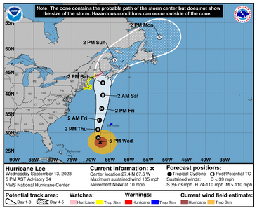
Excellent model agreement for this track. Again look at the wind field and look at the cone. cone is only for the eye not the entire storm (the storm is going to be really big which is why I worry for you guys up there)


493
WTNT43 KNHC 132045
TCDAT3

Hurricane Lee Discussion Number 34
NWS National Hurricane Center Miami FL AL132023
500 PM AST Wed Sep 13 2023

The Air Force Hurricane Hunters investigated Lee earlier this
afternoon and found that the hurricane has lost some strength. The
initial intensity is lowered to 90 kt based on the aircraft data.
Although the core winds have decreased some, the wind field has
become quite expansive, with the hurricane-force winds now extending
roughly 100 n mi away from the center. The satellite appearance of
Lee has been relatively steady state through the day and there is
still evidence of concentric eyewalls.

Lee's forward speed is beginning to increase, and it is now moving
north-northwestward at 9 kt. A progressively faster motion to the
north on the west side of a subtropical ridge is forecast during the
next couple of days, taking the core of the system to the west of
Bermuda Thursday and Thursday night. The combination of a shortwave
trough over the Mid-Atlantic States and a building ridge extending
into Atlantic Canada should cause Lee to turn slightly to the left
Friday night and Saturday, which will likely bring Lee close to
southeastern New England before it moves near or over Maine and
Atlantic Canada later in the weekend. The GFS and ECMWF models
have converged, and are now near the previous NHC track forecast.
The new NHC track forecast is again just an update of the previous
one and near the various consensus models.

The environment ahead of Lee is expected to gradually become less
conducive for the hurricane as it moves into a region of higher
wind shear, drier air, and over progressively cooler SSTs. These
conditions favor weakening, but since the system is so large the
weakening process should be slow.
The NHC intensity forecast is a
little lower than the previous one, in part due to the initial lower
wind speed, and remains near the HCCA and IVCN guidance.
Regardless of the details, there is high confidence that Lee will be
a large hurricane near the coast of New England Friday night and
Saturday.


It should again be noted that the 34- and 50-kt wind speed
probabilities beyond 36 hours in the text and graphical products are
likely underestimating the risk of those winds occurring. This is
because the forecast wind field of Lee is considerably larger than
average compared to the wind field used to derive the wind speed
probability product.


KEY MESSAGES:

1. Tropical storm conditions, heavy rainfall, and high surf are
expected to impact Bermuda beginning early Thursday, and a Tropical
Storm Warning is in effect for the island.

2. Hurricane conditions, heavy rainfall, and coastal flooding are
possible in portions of eastern Maine on Saturday, and a Hurricane
Watch has been issued for that area.

3. There is the potential for life-threatening storm surge flooding
in portions of southeastern Massachusetts, including Cape Cod and
Nantucket, late Friday and Saturday, where a Storm Surge Watch has
been issued.

4. Tropical storm conditions are possible over a large portion of
coastal New England, including Cape Cod, Nantucket, Martha's
Vineyard, and Block Island, where a Tropical Storm Watch has been
issued.


FORECAST POSITIONS AND MAX WINDS

INIT 13/2100Z 27.4N 67.6W 90 KT 105 MPH
12H 14/0600Z 28.7N 68.1W 90 KT 105 MPH
24H 14/1800Z 30.9N 68.2W 85 KT 100 MPH
36H 15/0600Z 33.4N 67.8W 80 KT 90 MPH
48H 15/1800Z 36.4N 67.2W 75 KT 85 MPH
60H 16/0600Z 39.7N 66.9W 70 KT 80 MPH
72H 16/1800Z 42.6N 66.9W 65 KT 75 MPH
96H 17/1800Z 47.7N 63.8W 45 KT 50 MPH...POST-TROP/EXTRATROP
120H 18/1800Z 52.3N 52.1W 35 KT 40 MPH...POST-TROP/EXTRATROP

$$
Forecaster Cangialosi
 
Oh gosh I hope not! Our last winter there (well MY last winter because he was already in Florida) one of the big pines fell and just missed the house. when it fell the ground shook and freaked me out. Last time I allowed a tree big enough to take a house out be around me like that.

I removed where I could, but I abut wetlands and have a 100ft buffer zone. Permits required to remove any trees. And they aren't easy to get unless the tree is in really bad shape, and mine apparently isn't. So I have them keeping a watch on it.

We are definitely getting warning notices here for coastal areas and even wind and rain warnings inland. I feel really bad for the folks who get water in their basements and rely on sump pumps. If the power goes out and they don't have a generator they are in trouble. We've had so much rain already, the ground is saturated.
 
I don’t know if anyone reading the thread watches Tiktoks but this one showed up on my feed today and I thought I’d share it here. It’s a fisherman in Maine who’s talking about (and showing) how oddly the birds are behaving. It’s pretty frightening, honestly. Hoping those of you located in the path of Lee stay safe.

 
I don’t know if anyone reading the thread watches Tiktoks but this one showed up on my feed today and I thought I’d share it here. It’s a fisherman in Maine who’s talking about (and showing) how oddly the birds are behaving. It’s pretty frightening, honestly. Hoping those of you located in the path of Lee stay safe.


That's very interesting. I have an app that people from my area post to about wildlife and all week they have been saying the birds have disappeared. Some had said it was normal migration, but the birds that don't migrate aren't around either. Another thought was that it has been so abnormally warm up here that they went north instead of south. This Tiktok gives even another possibility. Kind of scary for us in New England.
 
@monarch64 I notice that all the time here. When a hurricane is on the west side of the state, we get more birds over here. When its over on this side, we lose some.

Idahlia, my dogs are being absolutely nuts and of course, I had the worst headache.

The animals absolutely know.

@Lookinagain Mass is very strict for sure. I remember someone across the street from me getting fined for building a doc on the lake over there. They just happened to be inspecting the house next door and saw it.

1694693328779.png


860
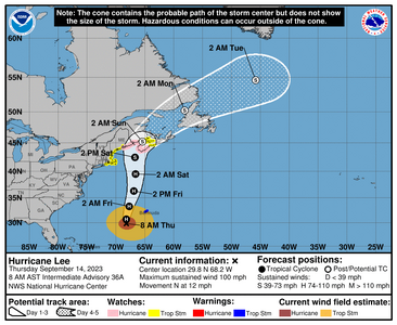
WTNT43 KNHC 140849
TCDAT3

Hurricane Lee Discussion Number 36
NWS National Hurricane Center Miami FL AL132023
500 AM AST Thu Sep 14 2023

Lee's satellite presentation has been a little deceiving early this
morning, as earlier reconnaissance flight-level and dropsonde
surface wind data indicated that the hurricane's center was located
about 15-20 n mi to the west of the satellite eye feature. On the
last couple of passes of the Air Force Reserve C-130 through the
center, the highest 700-mb wind measured was 95 kt, and peak SFMR
readings from both the Air Force and NOAA were 70-75 kt. Accounting
for some undersampling, Lee's initial intensity is reduced slightly
to 85 kt.

The initial motion remains 350/8 kt. A faster northward motion,
with some wobbles, is expected during the next 2-3 days as Lee
moves between a mid-tropospheric high over the west-central Atlantic
and a deep-layer trough over the eastern United States. As noted
in earlier forecasts, a slight bend to the west toward the Gulf
of Maine is likely in 48-60 hours when Lee interacts with the tail
end of the trough over the Mid-Atlantic states.
A turn toward the
north-northeast and then northeast is forecast on days 3 and 4,
bringing Lee's center across Atlantic Canada. The NHC track
forecast is nearly on top of the previous forecast, largely due to
consistent and tightly clustered model guidance.

The latest shear analyses suggest that moderate southwesterly shear
has begun to affect Lee, and this is confirmed by the offset of
the aircraft fixes relative to the satellite eye feature. The
shear is forecast to increase further in 24-36 hours, which will
cause Lee to ingest drier and more stable air into its circulation.
In addition, sea surface temperatures along Lee's future path drop
off significantly after 36 hours. Therefore, continued gradual
weakening is forecast, and the NHC intensity forecast is at or
slightly above the intensity consensus aids for much of the
forecast period. Extratropical transition is likely to begin on
Friday as Lee interacts with a frontal boundary moving off the east
coast of the United States, and a good chunk of the guidance
suggests the transition could be complete by 60 hours.
In order to
maintain continuity with the previous forecast, Lee is now shown to
be a fully post-tropical cyclone by 72 hours. Regardless of its
designation, Lee will remain a large and dangerous cyclone while it
approaches eastern New England and Atlantic Canada into the weekend.


KEY MESSAGES:

1. Tropical storm conditions, heavy rainfall, and high surf are
beginning to impact Bermuda, and a Tropical Storm Warning is in
effect for the island.

2. Hurricane conditions and coastal flooding are possible in
portions of eastern Maine, southern New Brunswick, and western Nova
Scotia on Saturday, and a Hurricane Watch is in effect for that
area. Heavy rainfall in these areas may produce localized urban
and small stream flooding from Friday night into Saturday night.
Tropical storm conditions are possible elsewhere across New England
and Atlantic Canada within the Tropical Storm Watch areas.

3. There is the potential for life-threatening storm surge flooding
in portions of southeastern Massachusetts, including Cape Cod and
Nantucket, late Friday and Saturday, where a Storm Surge Watch is
in effect.


FORECAST POSITIONS AND MAX WINDS

INIT 14/0900Z 29.1N 68.1W 85 KT 100 MPH
12H 14/1800Z 30.7N 68.2W 80 KT 90 MPH
24H 15/0600Z 33.3N 67.7W 80 KT 90 MPH
36H 15/1800Z 36.3N 66.9W 75 KT 85 MPH
48H 16/0600Z 39.5N 66.6W 70 KT 80 MPH
60H 16/1800Z 42.5N 66.7W 60 KT 70 MPH
72H 17/0600Z 45.2N 65.4W 50 KT 60 MPH...POST-TROP/EXTRATROP
96H 18/0600Z 50.2N 58.1W 40 KT 45 MPH...POST-TROP/EXTRATROP
120H 19/0600Z 54.6N 45.8W 40 KT 45 MPH...POST-TROP/EXTRATROP

$$
Forecaster Berg
 
That's very interesting. I have an app that people from my area post to about wildlife and all week they have been saying the birds have disappeared. Some had said it was normal migration, but the birds that don't migrate aren't around either. Another thought was that it has been so abnormally warm up here that they went north instead of south. This Tiktok gives even another possibility. Kind of scary for us in New England.

I checked the migration map (BirdCast.info) and it’s not a migratory thing. Very weird!
 
1694722711949.png

000
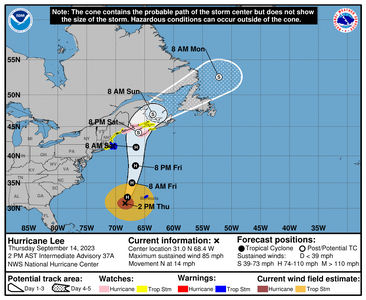
WTNT43 KNHC 141441
TCDAT3

Hurricane Lee Discussion Number 37
NWS National Hurricane Center Miami FL AL132023
1100 AM AST Thu Sep 14 2023

The satellite presentation of Lee has degraded over the past day or
so. An eye is no longer apparent but deep convection continues to
wrap around the eastern and northern portions of the circulation.
Deep convection has waned over the southwestern portions of the
cyclone, likely due to an increase in southwesterly vertical wind
shear and dry air entrainment. An Air Force Reserve reconnaissance
aircraft that has been investigating Lee this morning has measured
peak 700-mb flight-level winds of 96 kt, and the NOAA P-3 aircraft
has found peak 8000 ft flight-level winds of 100 kt. However, peak
SFMR winds from both aircraft have been around 70 kt. Using a blend
of the flight-level and SFMR data, the initial wind speed has been
lowered to 80 kt, but this could be a little generous.


Lee is moving northward at a slightly faster forward speed of 12 kt.
A faster northward to north-northeastward motion is expected during
the next day or so around the western side of a mid-level ridge over
the central Atlantic. A slight bend to the north-northwest toward
the Gulf of Maine is likely late Friday or early Saturday as the
southern extent of mid-latitude trough moves off the Mid-Atlantic
coast. After that time, Lee is forecast to turn northeastward over
Atlantic Canada. The dynamical model guidance is tightly clustered
and only minor adjustments were made to the previous official
forecast. The NHC track is close to a blend of the typically
reliable GFS and ECMWF models.

Southwesterly vertical wind shear is expected to increase over Lee
during the next 24 to 36 hours, and this is likely to lead to
gradual weakening during that time. Sea surface temperatures will
decrease significantly just after 36 hours when Lee moves north of
the Gulf Stream.
The global model guidance suggests that Lee will
begin extratropical transition Friday night and this is likely to be
completed within 48 hours, if not a little sooner. The NHC
intensity forecast is a blend of the HFIP corrected consensus and
and the IVCN consensus model. It can't be stressed enough, that
regardless of Lee's designation, it will remain a large and
dangerous cyclone while it approaches eastern New England and
Atlantic Canada.


KEY MESSAGES:

1. Tropical storm conditions, heavy rainfall, and high surf will
continue to impact Bermuda through Friday morning, and a Tropical
Storm Warning is in effect for the island.

2. Hurricane conditions and coastal flooding are possible in
portions of eastern Maine, southern New Brunswick, and western Nova
Scotia on Saturday, and a Hurricane Watch is in effect for that
area. Tropical storm conditions are expected on Cape Cod, Martha's
Vineyard, and Nantucket where a Tropical Storm Warning is now in
effect. Tropical storm conditions are possible elsewhere across New
England and Atlantic Canada within the Tropical Storm Watch areas.

3. Heavy rainfall from Lee may produce localized urban and small
stream flooding across eastern New England and into portions of New
Brunswick and Nova Scotia from Friday night into Saturday night.

4. There is the potential for life-threatening storm surge flooding
in portions of southeastern Massachusetts, including Cape Cod and
Nantucket, late Friday and Saturday, where a Storm Surge Watch is in
effect.

FORECAST POSITIONS AND MAX WINDS

INIT 14/1500Z 30.4N 68.3W 80 KT 90 MPH
12H 15/0000Z 32.2N 68.0W 75 KT 85 MPH
24H 15/1200Z 35.0N 67.2W 70 KT 80 MPH
36H 16/0000Z 38.2N 66.6W 70 KT 80 MPH
48H 16/1200Z 41.5N 66.5W 65 KT 75 MPH
60H 17/0000Z 44.0N 66.1W 55 KT 65 MPH...POST-TROP/EXTRATROP
72H 17/1200Z 47.0N 63.6W 45 KT 50 MPH...POST-TROP/EXTRATROP
96H 18/1200Z 52.6N 52.2W 35 KT 40 MPH...POST-TROP/EXTRATROP
120H 19/1200Z...DISSIPATED

$$
Forecaster Brown
 
My sister in NS informed me earlier today that the morning was eerily still...A few hours later, the first of the rain hit—torrential! She's in southwestern NS.

Fortunately she lives in a high area, and away from the water. However, they're surrounded by huge maple and other trees. Yikes! It's a stressful waiting game. All they can do is "batten the hatches" and hope for the best.

HOLD TIGHT!
 
The eye of Lee is finally past Bermuda though they are still getting nasty weather!

@SparklieBug thats crazy! I shouldn't be surprised given the size of the storm but just says how much of an anomaly this thing is. They don't usually get this big

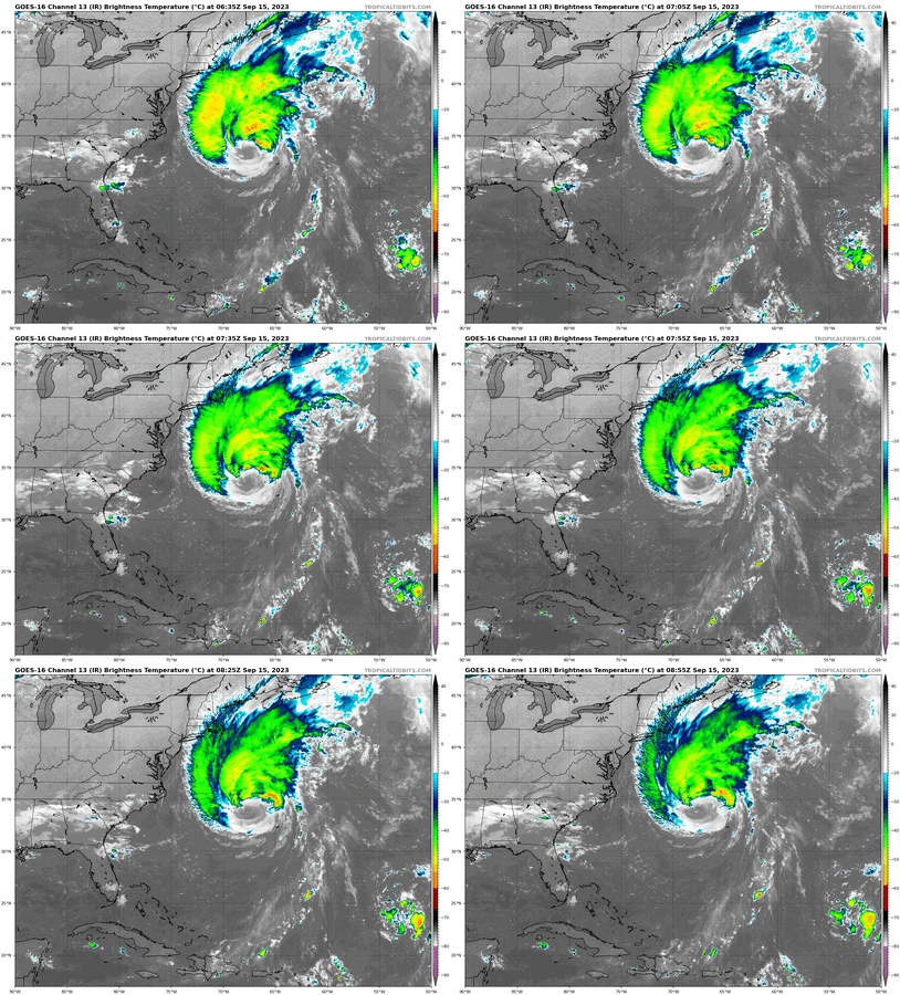
goes16_ir_nwatl.gif

1694779425916.png

000
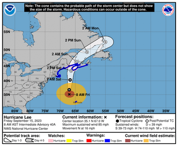
WTNT43 KNHC 150854
TCDAT3

Hurricane Lee Discussion Number 40
NWS National Hurricane Center Miami FL AL132023
500 AM AST Fri Sep 15 2023

Lee appears to be in the very initial stages of extratropical
transition. The cloud pattern is becoming increasingly asymmetric,
and scatterometer data from last evening showed a band of strong
winds developing along a boundary to the northwest of the center.
Lee's initial intensity remains 75 kt based on continuity from last
evening's reconnaissance and scatterometer data, but NOAA and Air
Force Reserve Hurricane Hunter aircraft should be in the storm in a
couple of hours to again sample the wind field.

Lee has been wobbling a bit since yesterday afternoon, but the
smoothed motion is northward (010 degrees) at a faster speed of 14
kt. Additional northward acceleration is expected during the next
24-36 hours as Lee moves along the western periphery of a mid-level
ridge, and approaches a trough currently over New England. The
track model guidance continues to be in very good agreement on
bringing Lee's center very near the western end of Nova Scotia by
Saturday afternoon, although the new NHC forecast is a little
faster than the previous prediction. In 2-3 days, Lee is forecast
to turn north-northeastward and northeastward across Atlantic
Canada as it moves between the aforementioned ridge and a mid-level
trough moving across Quebec.

Although southerly shear is forecast to increase markedly through
the day, baroclinic influences during Lee's extratropical transition
are likely to keep the intensity relatively steady for the next 24
hours or so.
During that time, the NHC intensity forecast is near
the top end of the guidance suite, closest to the GFS and ECMWF
solutions, and there is some possibility that a band of strong winds
could develop near the front on the western side of the circulation
over the Gulf of Maine. Extratropical transition is forecast to be
complete by 36 hours (although it could be sooner), and Lee is
likely to be weakening--but still near or just below hurricane
force--as it is approaching Nova Scotia due to the continued shear
and much colder ocean temperatures.
Lee is expected to continue
weakening while it moves across Atlantic Canada, and global model
fields indicate that it is likely to be absorbed by another
developing area of low pressure near Newfoundland and Labrador just
after 72 hours.


KEY MESSAGES:

1. Hurricane conditions are possible across portions of Down East
Maine, southern New Brunswick, and western Nova Scotia on Saturday
within the Hurricane Watch area. Tropical storm conditions and
coastal flooding are expected to begin in southern New England
within the Tropical Storm Warning area this afternoon, and spread
northward along the coast of New England and over portions of
Atlantic Canada through Saturday. These conditions are likely to
lead to downed trees and potential power outages.

2. Heavy rainfall from Lee may produce localized urban and small
stream flooding across eastern New England and into portions of New
Brunswick and Nova Scotia from tonight into Saturday night.

3. Tropical storm conditions and high surf will continue to impact
Bermuda through this morning.


FORECAST POSITIONS AND MAX WINDS

INIT 15/0900Z 34.4N 67.5W 75 KT 85 MPH
12H 15/1800Z 36.8N 67.0W 75 KT 85 MPH
24H 16/0600Z 40.3N 66.7W 75 KT 85 MPH
36H 16/1800Z 43.4N 66.4W 60 KT 70 MPH...POST-TROP/EXTRATROP
48H 17/0600Z 46.3N 64.8W 50 KT 60 MPH...POST-TROP/INLAND
60H 17/1800Z 49.3N 61.1W 40 KT 45 MPH...POST-TROP/EXTRATROP
72H 18/0600Z 52.2N 55.0W 35 KT 40 MPH...POST-TROP/EXTRATROP
96H 19/0600Z...DISSIPATED

$$
Forecaster Berg
 
Thank you for your continued updates @Arcadian
We are seeing dangerous riptides, high winds and flooding here at the jersey coast
Which is nothing compared to what y’all experiencing. Stay safe!
 
Be safe you guys. Its really going to be live from this point forward.

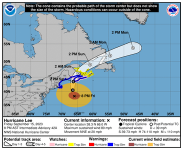
Lee is really cooking with gas and going about 20MPH. Thats good, at least its moving quickly

1694824854431.png


997
WTNT43 KNHC 152049
TCDAT3

Hurricane Lee Discussion Number 42
NWS National Hurricane Center Miami FL AL132023
500 PM AST Fri Sep 15 2023

Lee remains a very large hurricane over the western Atlantic. ASCAT
data from this morning showed the wind field expanding, with the
hurricane-force winds around 100 miles and tropical-storm-force
winds more than 300 miles outward from the center
. New data from
the Air Force Hurricane Hunters indicate that the core winds remain
steady with an intensity of 70 kt. Lee continues to be an
asymmetric hurricane with most of the convection on the north side
of the system.

The hurricane continues to wobble around, but it is generally moving
northward at 17 kt during the last 12-18 hours on the western side
of a subtropical ridge. Lee will continue to move northward around
the same speed until it makes landfall in Atlantic Canada in
approximately 24 to 30 hours.
Once Lee makes landfall, it is still
expected to accelerate to the northeast as it moves in the flow on
the east side of an approaching trough. The models remain in quite
good agreement, and the NHC track forecast was only slightly
shifted to the left to follow the new guidance through landfall.
Otherwise, no significant changes were made.

Southerly vertical wind shear and dry air continue eroding deep
convection on Lee's south side. These environmental conditions will
persist while Lee moves over sharply cooler waters when it crosses
the north wall of the Gulf Stream during the next day or so.
Therefore, gradual weakening is forecast and Lee will likely become
a strong extratropical cyclone around the time it makes landfall.

The NHC intensity forecast is slightly lower than the previous one
and continues to be fairly close to the GFS model. However, Lee is
expected to remain a very large and dangerous system over the next
couple of days.

KEY MESSAGES:

1. Hurricane conditions are possible across portions southern New
Brunswick, and much of Nova Scotia on Saturday within the Hurricane
Watch area. Tropical storm conditions and coastal flooding are
expected to begin in southern New England within the Tropical Storm
Warning area this evening, and spread northward along the coast of
New England and over portions of Atlantic Canada through Saturday.
These conditions are likely to lead to downed trees and potential
power outages.


2. Heavy rainfall from Lee could produce localized urban and small
stream flooding in portions of eastern Maine, New Brunswick and
western Nova Scotia Saturday.


FORECAST POSITIONS AND MAX WINDS

INIT 15/2100Z 37.9N 66.7W 70 KT 80 MPH
12H 16/0600Z 40.5N 66.5W 70 KT 80 MPH
24H 16/1800Z 43.5N 66.3W 60 KT 70 MPH
36H 17/0600Z 46.2N 64.7W 45 KT 50 MPH...POST-TROP/EXTRATROP
48H 17/1800Z 49.0N 60.9W 40 KT 45 MPH...POST-TROP/EXTRATROP
60H 18/0600Z 51.7N 54.4W 40 KT 45 MPH...POST-TROP/EXTRATROP
72H 18/1800Z 53.9N 47.1W 35 KT 40 MPH...POST-TROP/EXTRATROP
96H 19/1800Z...DISSIPATED

$$
Forecaster A Reinhart/Cangialosi
 
I have a slight breeze so far. That's about it. I think the Cape and Islands will get the most wind and some rain.
 
Thanks a lot for taking the time to update us @Arcadian - it's really helpful. Thinking of everyone affected by this storm. Stay safe everyone.
 
GET 3 FREE HCA RESULTS JOIN THE FORUM. ASK FOR HELP
Top