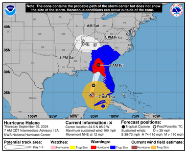
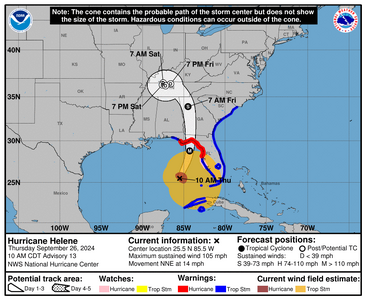
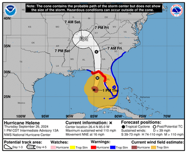
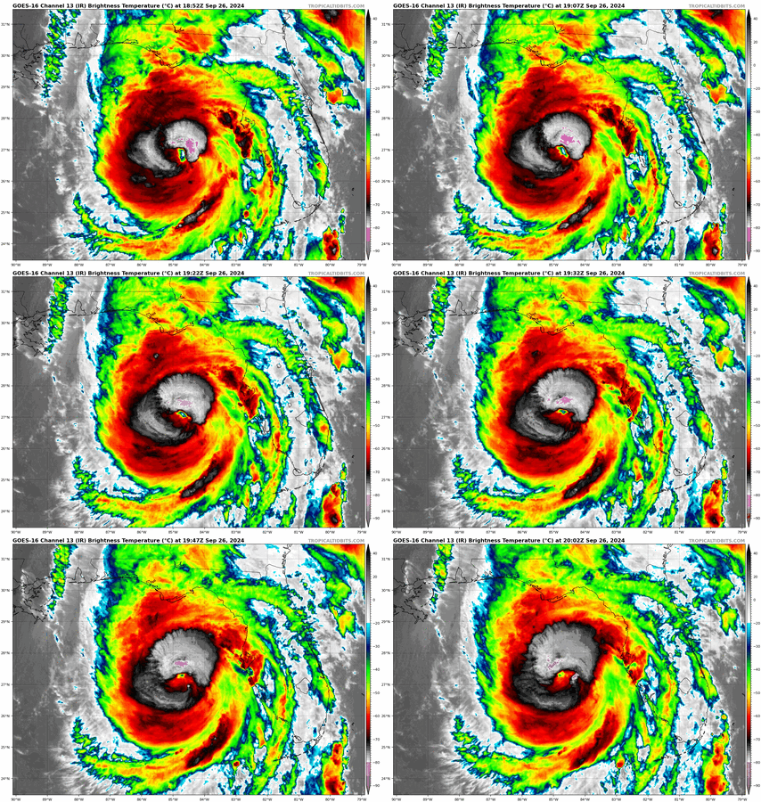
shape
carat
color
clarity

Storm Helene

Arcadian

Ideal_Rock
Premium
Joined
Sep 17, 2008
Messages
9,226
We have a name.

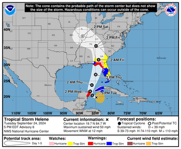
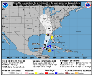
1727191282736.png


000
WTNT44 KNHC 241459
TCDAT4

Tropical Storm Helene Discussion Number 5
NWS National Hurricane Center Miami FL AL092024
1100 AM EDT Tue Sep 24 2024

An Air Force Reserve Hurricane Hunter measured peak 925-mb
flight-level winds of 52 kt to the northeast of the center, which
supports an initial intensity of 40 kt. Dropsonde data also
indicated that the central pressure is down to 1000 mb. Very
recently, data from the plane and one-minute visible satellite
imagery indicate that the center has become better defined. Based
on these data, the system is being designated as Tropical Storm
Helene at this time.

Helene is moving a little faster toward the northwest (310/10 kt)
as it moves around a mid-level area of high pressure located over
Florida and the Southeastern U.S. The high is expected to slide
eastward through Wednesday as a deep-layer trough digs southward
over the Lower Mississippi Valley. This pattern evolution should
cause the system to turn northward and north-northeastward late
Wednesday into Thursday. The track guidance is very tightly
clustered, which would normally imply high forecast confidence.
However, depending on exactly where the center forms could end up
shifting the entire guidance suite in future cycles, so it is
imperative to not focus on specific landfall locations this far in
the future.

Satellite trends suggest that the shear over the system is
beginning to decrease, and model guidance continues to show
relatively low to moderate shear for the next 48 hours or so. In
addition, oceanic heat content values are very high, and the system
will be moving through an environment of upper-level divergence.
Therefore, significant strengthening is anticipated, and the NHC
intensity forecast shows the system reaching a peak intensity
around 100 kt in 48 hours while over the eastern Gulf of Mexico.
There could be some increase in shear around the time the system
reaches the coast, given the system's large size, it might only
weaken slowly. As a result, there is still a risk that the system
could reach the coast as a major hurricane.

Helene's forecast radii are at the 90th percentile of hurricane
size at similar latitudes. Due to the forecast large size of this
system, storm surge, wind, and rainfall impacts will extend well
away from the center, particularly on the east side. In addition,
the fast forward speed while it crosses the coast will likely result
in farther inland penetration of strong winds over parts of the
southeastern United States after landfall.


KEY MESSAGES:

1. Helene is forecast to intensify and be near hurricane strength
when it reaches the far northwestern Caribbean Sea early Wednesday.
Tropical storm conditions are expected over portions of western
Cuba and the northeastern coast of the Yucatan Peninsula with
hurricane conditions possible.

2. Helene is expected to rapidly intensify over the eastern
Gulf of Mexico and be a major hurricane when it approaches the
northeastern Gulf Coast on Thursday. The risk of impacts from
life-threatening storm surge and damaging hurricane-force winds
continues to increase along the coast of the Florida Panhandle and
the Florida west coast. Hurricane and Storm Surge Watches are in
effect for much of that area and residents in those areas should
follow advice given by local officials.

3. Helene will bring heavy rain to portions of the western
Caribbean, which will cause considerable flooding and mudslides
across western Cuba. Heavy rainfall will likely result in locally
considerable flash and urban flooding across portions of Florida,
with isolated flash and urban flooding possible across the
Southeast, Southern Appalachians, and the Tennessee Valley
Wednesday through Friday. Minor to isolated moderate river flooding
will be possible.


FORECAST POSITIONS AND MAX WINDS

INIT 24/1500Z 19.5N 84.3W 40 KT 45 MPH
12H 25/0000Z 20.3N 85.2W 50 KT 60 MPH
24H 25/1200Z 21.5N 86.3W 65 KT 75 MPH
36H 26/0000Z 23.2N 86.3W 80 KT 90 MPH
48H 26/1200Z 25.9N 85.4W 100 KT 115 MPH
60H 27/0000Z 29.7N 84.3W 100 KT 115 MPH
72H 27/1200Z 33.9N 83.9W 45 KT 50 MPH...INLAND
96H 28/1200Z 39.7N 86.8W 20 KT 25 MPH...POST-TROPICAL
120H 29/1200Z...DISSIPATED

$$
Forecaster Berg
 
FYI, I'm like dog sick at the moment (Migraines!) Any time there's a big storm it happens and its been creeping all day. Tomorrow is going to be something else.
 
Hoping you’ll all be safe.
 
Hoping you’ll all be safe.

If this current track holds and doesn't move further east, most of us on the SE side will get what amounts to our afternoon thunderstorms all day, which are pretty violent in their own right! There may be some higher wind gusts and airports are going to close. The worst part about that is the ground here is already highly saturated so there's going to be lot of water in already soaked and flood prone areas that don't have a lot of places to go.
 
These Counties are in State of Emergency. https://www.floridadisaster.org/disaster-updates/storm-updates/

  • Alachua
  • Baker
  • Bay
  • Bradford
  • Brevard
  • Calhoun
  • Charlotte
  • Citrus
  • Clay
  • Collier
  • Columbia
  • DeSoto
  • Dixie
  • Duval
  • Escambia
  • Flagler
  • Franklin
  • Gadsden
  • Gilchrist
  • Glades
  • Gulf
  • Hamilton
  • Hardee
  • Hendry
  • Hernando
  • Highlands
  • Hillsborough
  • Holmes
  • Jackson
  • Jefferson
  • Lafayette
  • Lake
  • Lee
  • Leon
  • Levy
  • Liberty
  • Madison
  • Manatee
  • Marion
  • Monroe
  • Nassau
  • Okaloosa
  • Okeechobee
  • Orange
  • Osceola
  • Pasco
  • Pinellas
  • Polk
  • Putnam
  • Santa Rosa
  • Sarasota
  • Seminole
  • St. Johns
  • Sumter
  • Suwannee
  • Taylor
  • Union
  • Volusia
  • Wakulla
  • Walton
  • Washington
@tyty333 you're in Brevard yes?
 
Update - There's some time changes on this cone. Also based on modeling I also see where this storm stalls out in the Appalachians (THIS IS VERY BAD!).

As it stands its quite sunny and breezy, though humid (72% right now) in my location, with the winds coming from the south. We'll be seeing some minor bands tonight likely and getting stronger through the day.

Unsure if Disney is going to be open as they're blue shaded currently.
1727213237327.png


504
WTNT44 KNHC 242058
TCDAT4

Tropical Storm Helene Discussion Number 6
NWS National Hurricane Center Miami FL AL092024
500 PM EDT Tue Sep 24 2024

Deep convection is gradually filling in within Helene's
circulation, and the well-defined center that formed earlier this
morning is now obscured by cloudiness and showers. Data from NOAA
buoy indicate that the central pressure has fallen to 995 mb, and
the initial intensity is therefore estimated to be 45 kt. NOAA and
the Air Force Reserve Hurricane Hunters will be investigating Helene
this evening to provide more information about the storm's intensity
and structure.


With the center formation this morning, Helene has taken a
short-term jog to the west-northwest (300/10 kt). The storm is
expected to turn northwestward by tonight and then northward on
Wednesday as high pressure over Florida shifts eastward, and a
deep-layer trough digs southward over the Lower Mississippi Valley.

The NHC track forecast has been shifted westward during the first
24 hours to account for the recent motion, and Helene's center
could get very close to the northeastern coast of the Yucatan
Peninsula Wednesday morning. After that time, however, the NHC
track forecast is relatively unchanged from the previous
prediction, except for being a little bit slower based on the
latest guidance. Helene is expected to accelerate while it moves
northward across the eastern Gulf of Mexico and approaches the
Florida Gulf coast.

Warm sea surface temperatures, decreasing shear, and strong
upper-level divergence are likely to foster Helene's strengthening
while it moves across the northwestern Caribbean Sea and eastern
Gulf of Mexico. The statistical-dynamical SHIPS/LGEM models, as
well as the regional hurricane models, continue to show Helene
reaching major hurricane intensity while over the eastern Gulf of
Mexico, and that continues to be shown in the NHC forecast. Helene
could maintain that level of intensity until it reaches the Gulf
coast of Florida.


Of equal importance to the forecast intensity is Helene's forecast
size. Helene's forecast radii are at the 90th percentile of
major hurricane size at similar latitudes, and therefore storm
surge, wind, and rainfall impacts will likely extend well
away from the center and outside the forecast cone, particularly on
the east side.
In addition, the fast forward speed while it crosses
the coast will likely result in farther inland penetration of strong
winds over parts of the southeastern United States after landfall.


KEY MESSAGES:

1. Helene is forecast to intensify and be near hurricane strength
when it passes near the northeastern coast of the Yucatan
Peninsula on Wednesday, where a Hurricane Warning is in effect.

2. Helene is expected to rapidly intensify and grow in size over
the eastern Gulf of Mexico. There is a danger of life-threatening
storm surge along the entire west coast of the Florida Peninsula and
Florida Big Bend. The highest inundation levels are expected along
the coast of the Florida Big Bend. Residents in those areas should
follow advice given by local officials and evacuate if told to do
so.

3. Damaging hurricane-force winds are expected along portions of
coast of the Florida Big Bend, where a Hurricane Warning is now in
effect. Preparations to protect life and property should be
complete by early Thursday since tropical storm conditions are
expected to begin within this area on Thursday.


4. Helene will bring heavy rain to portions of the western Caribbean
with potentially significant flooding and mudslides across western
Cuba. Considerable flash and urban flooding is expected across
portions of Florida, the Southeast, southern Appalachians, and the
Tennessee Valley Wednesday through Friday. This includes the risk of
landslides across the southern Appalachians. Widespread minor to
moderate river flooding is likely, and isolated major river flooding
is possible.


FORECAST POSITIONS AND MAX WINDS

INIT 24/2100Z 19.7N 84.7W 45 KT 50 MPH
12H 25/0600Z 20.4N 86.0W 55 KT 65 MPH
24H 25/1800Z 21.7N 86.6W 65 KT 75 MPH
36H 26/0600Z 23.7N 86.1W 80 KT 90 MPH
48H 26/1800Z 27.0N 84.9W 100 KT 115 MPH <=====(this is important as its before landfall)
60H 27/0600Z 31.5N 84.0W 60 KT 70 MPH...INLAND
72H 27/1800Z 35.5N 84.8W 30 KT 35 MPH...INLAND
96H 28/1800Z 38.2N 89.0W 20 KT 25 MPH...POST-TROP/INLAND
120H 29/1800Z...DISSIPATED

$$
Forecaster Berg
 
Still a tropical storm but not for long. 4am I got an alert that we also went under tropical storm warning.

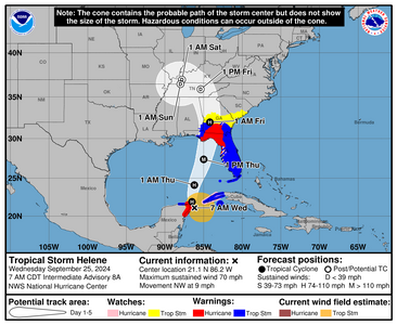
1727268232972.png


00
WTNT44 KNHC 250913 CCA
TCDAT4

Tropical Storm Helene Discussion Number 8...Corrected
NWS National Hurricane Center Miami FL AL092024
400 AM CDT Wed Sep 25 2024

Corrected Helen to Helene

Helene has strengthened some since the last advisory. Reports from
an Air Force Reserve Hurricane Hunter aircraft indicate that
the central pressure has fallen to 985 mb, and that the maximum
850 mb flight-level were 58 kt in the northeastern quadrant. A
dropsonde in the northwest quadrant reported a splash wind of 59
kt, but the boundary-layer average suggested sustained winds closer
to 45 kt. Based on these data and increasing satellite intensity
estimates, the initial intensity is increased to 55 kt. Despite
the increased intensity, the aircraft data, along with radar data
from Mexico and Cuba, show that Helene has not yet formed a
well-defined inner core.

The initial motion is 325/8 kt. Helene should turn northward
during the next 12 h or so on the western side of a mid-level
ridge, and then it should accelerate northward to
north-northeastward as it become embedded in the deep-layer flow
between the ridge and a mid-latitude trough/developing cut-off low
over the Mississippi valley. This motion should bring the center
near the northeastern coast of the Yucatan Peninsula this morning,
then across the eastern Gulf of Mexico tonight and Thursday to a
landfall along the northeast coast of the Gulf of Mexico late
Thursday or Thursday night. After landfall, Helene should curve
cyclonically around the cut-off low until it dissipates. The new
forecast track is little changed from the previous track.

Over the next couple of days, Helene will be moving through an
environment of low vertical wind shear, ample environmental
moisture, and over waters of high oceanic heat content. All
guidance forecasts steady to rapid intensification, including the
RI indices associated with the SHIPS model. The latest forecast
calls for a 105 kt intensity by 36 h, and this could be
conservative as some of the guidance is stronger. After landfall,
Helene is forecast to weaken and become post-tropical as it gets
tangled up in the baroclinic system over the southeastern United
States.

Helene's wind field is predicted to grow to a very large size in the
NHC forecast. Therefore storm surge, wind, and rainfall impacts
will likely extend well away from the center and outside the
forecast cone, particularly on the east side. In addition, the fast
forward speed while Helene crosses the coast will likely result in
farther inland penetration of strong winds over parts of the
southeastern United States after landfall.


KEY MESSAGES:

1. Helene is forecast to intensify and be near hurricane strength
when it passes near the northeastern coast of the Yucatan
Peninsula during the next several hours, where a Hurricane Warning
is in effect.

2. Helene is expected to rapidly intensify and grow in size over the
eastern Gulf of Mexico. There is a danger of life-threatening storm
surge along the entire west coast of the Florida Peninsula and
Florida Big Bend. The highest inundation levels are expected along
the coast of the Florida Big Bend. Residents in those areas should
follow advice given by local officials and evacuate if told to do
so.

3. Damaging hurricane-force winds are expected along portions of
coast of the Florida Big Bend, where a Hurricane Warning is now in
effect. Preparations to protect life and property should be
completed by early Thursday since tropical storm conditions are
expected to begin within this area on Thursday.

4. Tropical Storm Helene will bring heavy rain to portions of the
western Caribbean with potentially significant flooding across
western Cuba and the northeastern Yucatan Peninsula. Considerable
and potentially life-threatening flash and urban flooding is
expected across portions of Florida, the Southeast, the Southern
Appalachians, and the Tennessee Valley beginning today through
Friday. This includes the risk of landslides across the southern
Appalachians. Widespread minor to moderate river flooding is likely,
and isolated major river flooding is possible.


FORECAST POSITIONS AND MAX WINDS

INIT 25/0900Z 20.7N 86.2W 55 KT 65 MPH
12H 25/1800Z 21.9N 86.5W 70 KT 80 MPH
24H 26/0600Z 24.1N 86.2W 90 KT 105 MPH
36H 26/1800Z 27.4N 85.0W 105 KT 120 MPH

48H 27/0600Z 32.0N 84.2W 65 KT 75 MPH...INLAND
60H 27/1800Z 35.9N 85.4W 30 KT 35 MPH...POST-TROP/INLAND
72H 28/0600Z 37.0N 87.8W 20 KT 25 MPH...POST-TROP/INLAND
96H 29/0600Z 36.5N 88.0W 20 KT 25 MPH...POST-TROP/INLAND
120H 30/0600Z...DISSIPATED

$$
Forecaster Beven
.
 
Now a hurricane. Seems like each advisory gets more gnarly. Wind field on this is well beyond the size of the peninsula which is why both sides will feel the storm.

And my head of course is pounding like nuts which means I need to complete anything I can before tomorrow because I may well not be able to do anything.

Anyway Disney is monitoring https://disneyworld.disney.go.com/experience-updates/weather-updates/


The WaffleHouse on the other hand (at least the ones near me) will be open.
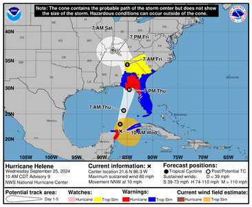
1727277444045.png

000
WTNT44 KNHC 251457
TCDAT4

Hurricane Helene Discussion Number 9
NWS National Hurricane Center Miami FL AL092024
1000 AM CDT Wed Sep 25 2024

Air Force Reserve and NOAA Hurricane Hunter aircraft have been
investigating Helene, with each plane recently measuring peak
flight-level winds of 81 kt and 78 kt, respectively. Helene has
therefore become a hurricane with an estimated intensity of 70 kt.
Dropsonde data also indicate that the pressure has fallen to about
979 mb. Radar data from Mexico and Cuba, as well as reconnaissance
reports, indicate that Helene has formed a partial, elliptical
eyewall that is open on the east side.


Helene has turned north-northwestward (330/9 kt) and is expected to
turn northward and north-northeastward later today and tonight,
bringing the center to the coast of the Florida Big Bend Thursday
evening. After landfall, Helene is expected to interact with a
deep-layer trough over the Lower Mississippi Valley and swing back
to the northwest and stall near the Tennessee Valley late Friday
into the weekend. The track guidance remains tightly clustered,
and the NHC forecast is generally just an update of the previous
prediction. It is still too soon at this point to be overly focused
on an exact landfall location and time, since NHC track forecasts
can be off by an average of 60 nm at the 36-hour forecast time.


Helene is expected to move through/over an environment of
relatively low shear, strong upper-level divergence, and sea
surface temperatures of 29-31 degrees Celsius, all of which should
foster additional strengthening. Rapid Intensification (RI)
indices indicate a high chance of RI during the next 24 hours, and
as a result the NHC intensity forecast shows Helene becoming a
major hurricane by Thursday morning. There is still some
uncertainty on exactly how strong Helene will get, and upward
adjustments to the forecast intensity could be required in
subsequent advisories if Helene rapidly intensifies more than
forecast.
Regardless, Helene is forecast to be a large major
hurricane when it reaches the Big Bend coast of Florida.
As a
result, storm surge, wind, and rainfall impacts will likely extend
well away from the center and outside the forecast cone,
particularly on the east side. In addition, the fast forward speed
while Helene crosses the coast will likely result in farther inland
penetration of strong winds over parts of the southeastern United
States after landfall, including strong gusts over higher terrain
of the southern Appalachians.


KEY MESSAGES:

1. Hurricane and tropical storm conditions are expected over
northeastern portions of the Yucatan Peninsula of Mexico today where
Tropical Storm and Hurricane Warnings are in effect. Tropical storm
conditions are occurring over portions of western Cuba within the
Tropical Storm Warning area, and hurricane conditions are possible
today within the Hurricane Watch area.

2. Due to the large size of Helene, there is a danger of
life-threatening storm surge along the entire west coast of the
Florida Peninsula and Florida Big Bend. The highest inundation of
greater than 10 ft is expected along the Florida Big Bend coast.
Residents in those areas should follow advice given by local
officials and evacuate if told to do so.

3. Devastating hurricane-force winds are expected across portions
of northern Florida and southern Georgia where the core of Helene
moves inland. Preparations to protect life and property should be
completed by early Thursday since tropical storm conditions are
expected to begin within these areas on Thursday. Because of
Helene’s expected fast forward speed, damaging and life-threatening
wind gusts, are expected to penetrate well inland over portions of
the southeastern United States, including in the higher terrain of
the southern Appalachians.

4. Helene will bring heavy rain to portions of the western
Caribbean with potentially significant flooding across western Cuba
and the northeastern Yucatan Peninsula into early Thursday.
Considerable and potentially life-threatening flash and urban
flooding is expected across portions of northwestern and northern
Florida, the Southeast, southern Appalachians, and the Upper
Tennessee Valley Wednesday through Friday. This includes the risk of
landslides across the southern Appalachians. Widespread minor to
moderate river flooding is likely, and isolated major river flooding
is possible.


FORECAST POSITIONS AND MAX WINDS

INIT 25/1500Z 21.6N 86.3W 70 KT 80 MPH
12H 26/0000Z 23.0N 86.4W 85 KT 100 MPH
24H 26/1200Z 25.7N 85.7W 105 KT 120 MPH
36H 27/0000Z 29.7N 84.6W 110 KT 125 MPH
48H 27/1200Z 34.3N 85.0W 50 KT 60 MPH...INLAND
60H 28/0000Z 36.6N 86.9W 30 KT 35 MPH...POST-TROP/INLAND
72H 28/1200Z 36.9N 87.8W 20 KT 25 MPH...POST-TROP/INLAND
96H 29/1200Z 36.6N 87.9W 15 KT 15 MPH...POST-TROP/INLAND
120H 30/1200Z...DISSIPATED

$$
Forecaster Berg
 
Yes, my county is in a state of emergency. It seems odd to be pretty far outside the cone but be in a SofE. I know
we'll be getting some rain and maybe some winds but shouldn't amount to a whole lot (hopefully, not just wishful thinking).
Worried about my folks on the other side of the state though. They are in their 80's. Still pretty capable but...you never
know what can happen in an emergency. Luckily my brother is there right now so they have help. They just made calls
earlier this week to get some estimates for a whole-house generator. Not going to be cheap but I hate the thought of them
stuck without power and dealing with the heat and humidity (worth it in my book.)

We have relatives in Gainesville and in Madison County, FL (which is directly in the cone.) Worried about them as well.
 
We are in Orlando visiting my dad and his wife. I'm hopeful we make it out tomorrow afternoon without incident and that by the time they're ready to go back to their house in North Carolina at the end of the week everything's OK. Two years ago we had to drive back to Chicago because all flights were canceled for days. I think that one was Ian... ?

Stay safe everyone.

I live in NC. We had a huge thunder/lightning storm last night that damaged my home. I'm expecting more strong storms later this week and anticipating issues through Sunday.

The weather channels here are predicting very severe weather for the mountain areas, like Boone and Asheville, with flooding, landslides, rockslides, downed trees, etc.

The National Park Service is planning to close parts of the Blue Ridge Parkway in western NC in stages starting this afternoon, and the governor has already declared a state of emergency. If your family is from this area, you might look up the Citizen Times, which has a lot of local info.

I hope this helps your family plan ahead.
 
We are in Orlando visiting my dad and his wife. I'm hopeful we make it out tomorrow afternoon without incident and that by the time they're ready to go back to their house in North Carolina at the end of the week everything's OK. Two years ago we had to drive back to Chicago because all flights were canceled for days. I think that one was Ian... ?

Stay safe everyone.
If you're flying, it will be dicey but this is live I believe

Driving? I would leave on the early side if its possible. I95 should be fine, but the smaller roads is what is going to be pretty rough.

Either way you're planning on leaving be safe lot of prayer and dust for safety.

Flights down here are very dicey as we're getting some pretty strong bands.
 
I’m all the way up in Indiana and we’re going to get hit with 55 mph winds from 3-9pm Friday. Yes, from Helene. In Indiana.

This happened to my city after Beryl as well. Lost power for 26 hours myself, other parts lost it for 3 days. A lot of people weren’t expecting it and lost a lot of food. Now that the university students are back things may be worse than they were in June-there are 40k of them who won’t know what the hell’s going on.
 
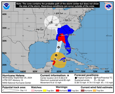
1727300761970.png

Weather is going to continue to deteriorate overnight tonight. I will probably not be sleeping a lot because these gusts are not fun at all.


000
WTNT44 KNHC 252056
TCDAT4

Hurricane Helene Discussion Number 10
NWS National Hurricane Center Miami FL AL092024
400 PM CDT Wed Sep 25 2024

A ragged eye is becoming apparent in visible satellite imagery and
has also been observed in recent radar data from Cancun and western
Cuba. Based on the improved structure, the initial intensity is
set at 75 kt, which is at the high end of the satellite intensity
estimates. This is also supported by the earlier Air Force Reserve
reconnaissance mission, which measured a peak 700-mb flight-level
wind of 81 kt.

Helene has turned northward (355/9 kt) and is expected to
accelerate toward the north or north-northeast during the next
24-36 hours as it moves across the Gulf of Mexico and crosses the
Florida Big Bend coast Thursday evening. After landfall, the
system is forecast to interact with a deep-layer trough to the west
and turn northwestward with a decrease in speed over the Tennessee
Valley.

The environment appears primed for significant strengthening while
Helene moves across the Gulf of Mexico. The forecast track more or
less runs along the axis of the Loop Current during the next 24
hours, where ocean temperatures are about 30 degrees Celsius. In
addition, Helene will be moving through an environment of low
vertical shear and strong upper-level divergence. Some of the
Rapid Intensification (RI) indices, particular DTOPS, respond to
this environment by indicating at least a 90 percent chance of a
35-kt increase in intensity over the next 24 hours. The NHC
intensity forecast now shows an intensity of 115 kt (Category 4) at
24 hours, which is mirrored by several of the regional hurricane
models and the SHIPS guidance. It should be noted that additional
strengthening is possible beyond 24 hours before Helene makes
landfall Thursday evening.

Helene is forecast to be a large major hurricane when it reaches the
Big Bend coast of Florida. As a result, storm surge, wind, and
rainfall impacts will extend well away from the center and outside
the forecast cone, particularly on the east side. In addition, the
fast forward speed when Helene moves inland will result in a far
inland penetration of strong winds over parts of the southeastern
United States, including strong gusts over higher terrain of the
southern Appalachians. A higher-than-normal gust factor has been
indicated in the official forecast while Helene is inland.


KEY MESSAGES:

1. A catastrophic and deadly storm surge is likely along portions
of the Florida Big Bend coast, where inundation could reach as high
as 20 feet above ground level, along with destructive waves. There
is also a danger of life-threatening storm surge along the remainder
of the west coast of the Florida Peninsula. Residents in those
areas should follow advice given by local officials and evacuate if
told to do so.

2. Potentially catastrophic hurricane-force winds are expected
within the eyewall of Helene when it makes landfall in the Florida
Big Bend region late Thursday. Preparations to protect life and
property should be completed by early Thursday before tropical
storm conditions arrive. Damaging and life-threatening
hurricane-force winds, especially in gusts, will penetrate well
inland over portions of northern Florida and southern Georgia late
Thursday and Thursday night where Hurricane Warnings are in effect.
Strong wind gusts are also likely farther north across portions of
northern Georgia and the Carolinas, particularly over the higher
terrain of the southern Appalachians.

3. Catastrophic and life-threatening flash and urban flooding,
including landslides, is expected across portions of the southern
Appalachians through Friday. Considerable to locally catastrophic
flash and urban flooding is likely for northwestern and northern
Florida and the Southeast through Friday. Widespread minor to
moderate river flooding is likely, and isolated major river flooding
is possible.

4. Hurricane and tropical storm conditions are expected over
northeastern portions of the Yucatan Peninsula of Mexico this
evening where Tropical Storm and Hurricane Warnings are in effect.
Tropical storm conditions are occurring over portions of western
Cuba within the Tropical Storm Warning area, and hurricane
conditions are possible this evening within the Hurricane Watch
area. Helene will bring heavy rain to portions of the western
Caribbean with potentially significant flooding across western Cuba
and the northeastern Yucatan Peninsula into early Thursday.


FORECAST POSITIONS AND MAX WINDS

INIT 25/2100Z 22.5N 86.6W 75 KT 85 MPH
12H 26/0600Z 24.1N 86.2W 95 KT 110 MPH
24H 26/1800Z 27.4N 85.2W 115 KT 130 MPH
36H 27/0600Z 32.1N 84.6W 70 KT 80 MPH...INLAND
48H 27/1800Z 36.1N 86.0W 35 KT 40 MPH...POST-TROP/EXTRATROP
60H 28/0600Z 37.1N 88.1W 25 KT 30 MPH...POST-TROP/EXTRATROP
72H 28/1800Z 36.8N 88.7W 20 KT 25 MPH...POST-TROP/EXTRATROP
96H 29/1800Z 37.0N 88.0W 15 KT 15 MPH...POST-TROP/EXTRATROP
120H 30/1800Z...DISSIPATED

$$
Forecaster Berg
 
You all are in my thoughts! Do everything you can to stay safe. Please head all warnings. This is a very serious situation. I've been through my share of hurricanes and Mother Nature is not to be underestimated.
 
Right now where I am its kinda sorta quiet. I hear thunder but its definitely big thunder though its far away. the air is stupid thick, its hot even though temp wise its 81 degrees. feels closer to 85 honestly.

we have a squall line thats about 45 minutes away,
 
GET 3 FREE HCA RESULTS JOIN THE FORUM. ASK FOR HELP
Top