shape
carat
color
clarity

Storm Helene

I got her, brought her home, and doped her up. she's now in la la land. Ivy is my nutty girl. We've been on 3 walks already before this whole thing started going nuts. She's also doped up.

Glad you made it home safely! Take care as this weather progresses!
 
I know you all are wise who live in Florida, and are well aware of all the risks, but batten down the hatches and be safe - please don't "just run to the store quick" for this or that. Hunker down (including you Arc, since this is such a major), please
 
Right now here (in Kissimmee, six miles from the entrance to Disney) the rain is hitting the windows pretty hard, but I think that's about it. MCO flight delays are running 15 minutes or less, and traffic to the airport looks to be a normal time. We are going to head out very early though because who knows what will be going on for our flight this afternoon. Glad we got gas last night.

Hope you made your flight and are safe. Check in with us when you can!
 
MGR: I think I've found my companion worrier, lol!
 
Thinking of everyone in the line and surround of this brutal storm. Stay safe, thanks to @Arcadian for her detailed updates. Check in when you can folks!
 
MGR: I think I've found my companion worrier, lol!

I can’t say for sure but I think I was probably worried about something on the day I was born! It never really lets up although I long ago accepted the fact that so many things are simply out of my control. I have maybe been able to tamp down worries about things that probably won’t be worrisome in a year, but there always seem to be those things in the forefront that need worried about - lol! My father was a worrier too - we found a Worry Bird statue many years ago in Florida on vacation that we bought for him. Just a haggard looking old bird that we all laughed about but when I run across it now, I think that is my future look!
 
I know you all are wise who live in Florida, and are well aware of all the risks, but batten down the hatches and be safe - please don't "just run to the store quick" for this or that. Hunker down (including you Arc, since this is such a major), please

We're in for the evening. we keep getting tornado warnings and being I'm originally from the midwest I know better than to be out when thats going on. Lot of places on the west coast (bridges) are now closed.
 
i have been reading about this this morning
all who will be effected are in my thoughts

please stay safe and do what you can to keep your family safe
 
The storm is moving really fast which is probably the biggest blessing down here. Ian, which was couple of years ago was very big but slower and caused a ton of damage.

Not that this one won't, but a slower storm would mean wide spread damage down here. Lot of places still are recovering from the mega storms from years past. Plus the area that Helene is hitting is heavily treed and does not have the same building codes as we do in South Florida. That may well be changing.
 
CNN snip:

Write your name and D.O.B. on your leg so your body can be IDed


From CNN Meteorologist Angela Fritz
Emergency managers in Taylor County, Florida, are not messing around.

The officials, who oversee low-lying towns including Steinhatchee and Perry, posted on Facebook Thursday afternoon to ask all residents who chose not to evacuate to grab a permanent marker and write their name and date of birth on their leg.

The unspoken message: You will not survive this. Help us identify you.

If you or someone you know chose not to evacuate, PLEASE write your, Name, birthday and important information on your arm or leg in A PERMANENT MARKER so that you can be identified and family notified.

Taylor County Sheriff's Office - Division of Emergency Management via Facebook

Officials also asked friends and relatives of people who did not evacuate to reach out and share the information, so search and rescue teams know where to focus their efforts when the storm passes.


Holy Crap! o_O
Nature can be so beautiful, so magnificent, yet so cruel!

Imagine what a new mom feels holding her newborn and a Sharpie to write its birthdate on the tiny leg. ;(

It makes me wonder whether parents who refuse to evacuate with their family (when they have the means) can be prosecuted if they survive but their kids don't. :nono:
 
Last edited:
for us its mostly quiet. thunder sure, no rain right now though and its freaking hot though its very breezy but I think we're going to get some nasty bands tonight.

Gigi pushed me for a early bedtime. So I sit here with my laptop (I have an adjustable bed thankfully) in the dark with them (they got extra cbd for the best sleeps). the husband is still watching tv. such is life with dogs...lol

there is a 9pm update and its not good.

845
WTNT64 KNHC 270056
TCUAT4

Hurricane Helene Tropical Cyclone Update
NWS National Hurricane Center Miami FL AL092024
900 PM EDT Thu Sep 26 2024

...HELENE SLIGHTLY STRONGER AS ITS EYE APPROACHES THE COAST OF THE
FLORIDA BIG BEND...
...900 PM EDT POSITION UPDATE...

A University of Florida Coastal Monitoring Program tower located on
Cedar Key recently reported a sustained wind of 55 mph (89 km/h) and
a wind gust of 73 mph (117 km/h).

A NOAA National Ocean Service tide gauge located at Clearwater Beach
recently reported a water level of 5.07 feet above mean higher high
water, which is an approximation of inundation in that area.

SUMMARY OF 900 PM EDT...0100 UTC...INFORMATION
----------------------------------------------
LOCATION...29.1N 84.2W
ABOUT 65 MI...105 KM W OF CEDAR KEY FLORIDA
ABOUT 90 MI...145 KM S OF TALLAHASSEE FLORIDA
MAXIMUM SUSTAINED WINDS...140 MPH...225 KM/H
PRESENT MOVEMENT...NNE OR 20 DEGREES AT 24 MPH...39 KM/H
MINIMUM CENTRAL PRESSURE...941 MB...27.79 INCHES


$$
Forecaster Bucci/Sardi
 
We made it back! Frankly it was one of the most civilized experiences I've ever had in the Orlando airport, which was much less full than normal. Tons of flights were cancelled, but as far as I could tell it was very dependent on where they were going and/or where the inbound flight was coming from (which of course makes sense). This return flight, which was pretty much full when I booked it, was more than half empty on the way home. There was some turbulence, but nothing too bad really.

I hope everyone down there is safe!
 
000
WTNT64 KNHC 270159
TCUAT4

Hurricane Helene Tropical Cyclone Update
NWS National Hurricane Center Miami FL AL092024
1000 PM EDT Thu Sep 26 2024

...EYEWALL OF EXTREMELY DANGEROUS CATEGORY 4 HELENE BEGINNING TO
MOVE ASHORE ALONG THE FLORIDA COAST OF THE BIG BEND...
...1000 PM EDT POSITION UPDATE...

Helene is producing catastrophic winds that will be spreading
onshore in the Florida Big Bend region during the next few hours.
This is an extremely dangerous and life-threatening situation.
Persons should not leave their shelters and remain in place through
the passage of these life-threatening conditions. When the eye
comes ashore, people are reminded to not venture out in the relative
calm, as hazardous winds will increase very quickly when the eye
passes.

A University of Florida Coastal Monitoring Program tower located on
Cedar Key recently reported a sustained wind of 59 mph (95 km/h)
and a wind gust of 78 mph (126 km/h).

A NOAA National Ocean Service tide gauge located at Clearwater Beach
recently reported a water level of 6.18 feet above mean higher high
water, which is an approximation of inundation in that area. A
National Ocean Service tide gauge at Cedar Key is reporting a water
level 5.76 feet above mean higher high water.


SUMMARY OF 1000 PM EDT...0200 UTC...INFORMATION
----------------------------------------------
LOCATION...29.5N 84.1W
ABOUT 65 MI...105 KM WNW OF CEDAR KEY FLORIDA
ABOUT 65 MI...105 KM S OF TALLAHASSEE FLORIDA
MAXIMUM SUSTAINED WINDS...140 MPH...225 KM/H
PRESENT MOVEMENT...NNE OR 20 DEGREES AT 24 MPH...39 KM/H
MINIMUM CENTRAL PRESSURE...939 MB...27.72 INCHES


$$
Forecaster Bucci/Sardi/Brown
 
Storm now coming ashore. I think Perry is what is being said. anyway its nasty very strong cat 4 with a low pressure. it will not take it long to get to Georgia.
 
my prayers for all of you effected, the video and images I have seen this morning are not good!
 
Its not over and unfortunately there were a lot of water rescues, also some that did not end well.

all total near 4 million people currently without power in the affected areas. Heck may be over, I'm just going by the power outage app.

The hotter the waters get in our oceans, the more these types of storms will become the norm.

And hurricane season isn't over.

1727439029100.png


000
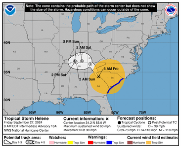
WTNT44 KNHC 270854
TCDAT4

Tropical Storm Helene Discussion Number 16
NWS National Hurricane Center Miami FL AL092024
500 AM EDT Fri Sep 27 2024

The eye of Helene made landfall near Perry, Florida, just after the
last advisory was issued. Since then, the center has crossed the
Florida Big Bend region and is currently located over east central
Georgia. Surface observations have shown steady weakening since
landfall, and the maximum winds have decreased to a possibly
generous 60 kt. During the last couple of hours, the radar
signature of the cyclone has degraded, and based on this the hourly
Tropical Cyclone Updates will be discontinued.

The initial motion is now northward or 360/26. Helen should turn
northwestward later today as it starts to interact with a mid- to
upper-level baroclinic low to its northwest. After that, the
cyclone should considerably slow its forward motion and make a
cyclonic loop as it gets absorbed into the low. The new forecast
track follows the general trend of the large-scale dynamical models.

Helene should continue to weaken, and simulated satellite imagery
suggests it should lose its convection later today, the new
intensity forecast calls for the cyclone to weaken and become
post-tropical in about 12 h, followed by transition to an
extratropical cyclone as it merges with the baroclinic low. The
remnant extratropical low is expected to dissipate by 72 h.

Although the system will weaken as it moves over land, the fast
forward speed of Helene during the next 12 hours or so will result
in a far inland penetration of strong winds over parts of the
southeastern United States, particularly over northern Georgia,
including strong gusts over the higher terrain of the southern
Appalachians. Accordingly, a higher-than-normal gust factor is
indicated in the official forecast while Helene is inland.

KEY MESSAGES:

1. The storm surge along portions of the Florida Big Bend coast and
other portions of the west coast of Florida should subside today.

2. Damaging wind gusts will continue to penetrate well inland over
portions of Georgia and the Carolinas today, particularly over the
higher terrain of the southern Appalachians. Residents in these
areas should be prepared for the possibility of long-duration power
outages. If you use a generator after the storm, be sure it is
placed outside at least 20 feet away from doors, windows, and
garages to avoid deadly carbon monoxide poisoning.

3. Catastrophic and life-threatening flash and urban flooding,
including numerous significant landslides, is expected across
portions of the southern Appalachians through Friday. Considerable
to locally catastrophic flash and urban flooding is likely for
northwestern and northern Florida and the Southeast through Friday.
Widespread significant river flooding is likely, some of which will
be major to record breaking.


FORECAST POSITIONS AND MAX WINDS

INIT 27/0900Z 32.8N 83.0W 60 KT 70 MPH...INLAND
12H 27/1800Z 36.4N 84.5W 35 KT 40 MPH...POST-TROP/INLAND
24H 28/0600Z 36.9N 87.3W 30 KT 35 MPH...POST-TROP/EXTRATROP
36H 28/1800Z 36.7N 87.3W 25 KT 30 MPH...POST-TROP/EXTRATROP
48H 29/0600Z 36.7N 87.0W 20 KT 25 MPH...POST-TROP/EXTRATROP
60H 29/1800Z 36.9N 86.0W 20 KT 25 MPH...POST-TROP/EXTRATROP
72H 30/0600Z...DISSIPATED

$$
Forecaster Beven
 
Yes, my county is in a state of emergency. It seems odd to be pretty far outside the cone but be in a SofE. I know
we'll be getting some rain and maybe some winds but shouldn't amount to a whole lot (hopefully, not just wishful thinking).
Worried about my folks on the other side of the state though. They are in their 80's. Still pretty capable but...you never
know what can happen in an emergency. Luckily my brother is there right now so they have help. They just made calls
earlier this week to get some estimates for a whole-house generator. Not going to be cheap but I hate the thought of them
stuck without power and dealing with the heat and humidity (worth it in my book.)

We have relatives in Gainesville and in Madison County, FL (which is directly in the cone.) Worried about them as well.

Have you heard from your folks? Any family members. it was pretty bad in the cone. Something that covers the whole house is fantastic but as you said very expensive. I ended up with a portable because no natural gas near me and to do a big enough propane tank would have been nuts.
 
Looks like some smaller regional airports are closed in the current area.
1727457879770.png


000
WTNT44 KNHC 271436
TCDAT4

Tropical Storm Helene Discussion Number 17
NWS National Hurricane Center Miami FL AL092024
1100 AM EDT Fri Sep 27 2024

Helene has been racing northward and the low-level center is now
located over the southern Appalachians. Strong bands of heavy rain
and very gusty winds continue off and along the South Carolina
coast. In addition, wind gusts to around hurricane force have been
occurring this morning in portions of northeastern Georgia and the
western portions of the Carolinas, especially in areas of higher
terrain. The initial intensity is set at 40 kt, and these sustained
winds are likely occurring off the south Carolina coast and over
the Appalachians. The main hazard is the very heavy rainfall
ongoing over portions of the southeastern U.S., which is
causing historic and life-threatening flooding.

Helene is expected to move slower to the northwest later today and
then stall over the Tennessee Valley tonight and through the weekend
as it merges with a mid- to upper-level low. This merger will also
lead to extratropical transition, which is expected to occur later
today. The expected slow motion could result in significant
flooding over the Ohio and Tennessee Valleys, and over the southern
Appalachians through the weekend.

KEY MESSAGES:

1. Historic, catastrophic and life-threatening flash and urban
flooding, including numerous significant landslides, will continue
across portions of the Southern Appalachians through this evening.
Widespread significant river flooding is ongoing, some of which will
be major to record breaking.

2. Damaging wind gusts will continue over portions of Georgia, the
Carolinas, Tennessee, and Kentucky today, particularly over the
higher terrain of the southern Appalachians.

3. There is a possibility of long-duration power outages in
portions of the southeast U.S. If you use a generator after the
storm, be sure it is placed outside at least 20 feet away from
doors, windows, and garages to avoid deadly carbon monoxide
poisoning.


FORECAST POSITIONS AND MAX WINDS

INIT 27/1500Z 35.1N 83.8W 40 KT 45 MPH
12H 28/0000Z 37.3N 85.6W 30 KT 35 MPH...POST-TROP/EXTRATROP
24H 28/1200Z 37.5N 86.5W 25 KT 30 MPH...POST-TROP/EXTRATROP
36H 29/0000Z 37.5N 86.4W 20 KT 25 MPH...POST-TROP/EXTRATROP
48H 29/1200Z 37.5N 86.1W 20 KT 25 MPH...POST-TROP/EXTRATROP
60H 30/0000Z 37.6N 85.7W 20 KT 25 MPH...POST-TROP/EXTRATROP
72H 30/1200Z...DISSIPATED

$$
Forecaster Cangialosi/Rosado
 
Folks who are in NC...


This is from facebook Rutherford County Emergency Management. https://www.facebook.com/rcemergencymanagement

LAKE LURE DAM UPDATE
9-27-24 at 1:30 PM: Water is cresting the Dam and flowing around the side walls. Structural supports have been compromised but the Dam wall is currently holding. Evacuations have occurred from the Dam to Island Creek Road. Evacuation sirens are sounding downstream of the Dam. Emergency personnel are working with the structural engineers and are going house to house to ensure all citizens have been evacuated. Evacuees are being transported temporarily to Ingles in Lake Lure. Text AlertRC to 888777 to get emergency updates
 
1727465101465.png

000
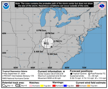
WTNT34 KNHC 271746
TCPAT4

BULLETIN
Tropical Depression Helene Intermediate Advisory Number 17A
NWS National Hurricane Center Miami FL AL092024
200 PM EDT Fri Sep 27 2024

...HELENE STILL PRODUCING HISTORIC AND CATASTROPHIC FLOODING OVER
PORTIONS OF THE SOUTHEAST AND SOUTHERN APPALACHIANS...


SUMMARY OF 200 PM EDT...1800 UTC...INFORMATION
----------------------------------------------
LOCATION...36.6N 84.6W
ABOUT 125 MI...205 KM SSE OF LOUISVILLE KENTUCKY
MAXIMUM SUSTAINED WINDS...35 MPH...55 KM/H
PRESENT MOVEMENT...NNW OR 330 DEGREES AT 28 MPH...44 KM/H
MINIMUM CENTRAL PRESSURE...982 MB...29.00 INCHES


WATCHES AND WARNINGS
--------------------
CHANGES WITH THIS ADVISORY:

All Tropical Storm Warnings have been discontinued.

SUMMARY OF WATCHES AND WARNINGS IN EFFECT:

There are no coastal watches or warnings in effect.

For storm information specific to your area, please monitor
products issued by your local National Weather Service forecast
office.


DISCUSSION AND OUTLOOK
----------------------
At 200 PM EDT (1800 UTC), the center of Tropical Depression Helene
was located near latitude 36.6 North, longitude 84.6 West. Helene is
moving toward the north-northwest near 28 mph (44 km/h). A slowdown
in forward speed is expected, and the depression is forecast to
stall over the Tennessee Valley tonight and through the weekend.

Maximum sustained winds have decreased to near 35 mph (55 km/h)
with higher gusts. Continued slow weakening is expected, and
Helene is forecast to become extratropical later this afternoon.

The estimated minimum central pressure based on surface
observations is 982 mb (29.00 inches).

HAZARDS AFFECTING LAND
----------------------
Key Messages for Helene can be found in the Tropical Cyclone
Discussion under AWIPS header MIATCDAT4 and WMO header WTNT44 KNHC
and on the web at hurricanes.gov/text/MIATCDAT4.shtml

STORM SURGE: Water levels will continue to recede along the Florida
Gulf Coast and portions of the southeast U.S. coast throughout the
day.

WIND: Gusts to tropical-storm-force are still occurring in portions
of the Appalachians and off the South Carolina coast, but they
should subside by this evening.

RAINFALL: Over portions of the Central and Southern Appalachians,
Helene is expected to produce additional rainfall amounts of 3 to 6
inches leading to total rain accumulations of 6 to 12 inches, with
isolated totals around 20 inches. This rainfall will result in
catastrophic and potentially life-threatening flash and urban
flooding, along with significant and record river flooding. Numerous
significant landslides are expected in steep terrain across the
Southern Appalachians.

For a complete depiction of forecast rainfall associated with
Helene, please see the National Weather Service Storm Total Rainfall
Graphic, available at hurricanes.gov/graphics_at4.shtml?rainqpf and
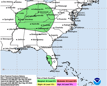
the Flash Flood Risk
graphic at hurricanes.gov/graphics_at4.shtml?ero.

For a list of rainfall observations (and wind reports) associated
this storm, see the companion storm summary at WBCSCCNS4 with the
WMO header ACUS44 KWBC or at the following link:
www.wpc.ncep.noaa.gov/discussions/nfdscc4.html

TORNADOES: Tornadoes are possible today across eastern South
Carolina, central and eastern North Carolina, and southern Virginia.

SURF: Swells generated by Helene will affect the coasts of Georgia
and the Carolinas during the next day or so. These swells are
likely to cause life-threatening surf and rip current conditions.
Please consult products from your local weather office.


NEXT ADVISORY
-------------
Next complete advisory at 500 PM EDT.

$$
Forecaster Cangialosi
 
I am in Ohio and we are getting way more rain and wind then they said we would get, my son has a buddy down in Asheville, NC and said it was horrid there as well, trees on the house, broken windows and flooding...I hope everyone stays safe!
 
This is going to be the last discussion issued on Helene from NHC


367
WTNT44 KNHC 272035
TCDAT4

Post-Tropical Cyclone Helene Discussion Number 18
NWS National Hurricane Center Miami FL AL092024
400 PM CDT Fri Sep 27 2024

Helene has been producing catastrophic flooding over portions of
the southeast U.S. and southern Appalachians, and the associated
heavy rains are shifting westward into the Ohio and Tennessee
Valleys. Satellite images and surface observations indicate that
Helene has completed extratropical transition, and the initial
intensity is set at 30 kt.


The cyclone is moving to the north-northwest at 15 kt. A slowdown
is expected tonight, and the cyclone is forecast to stall over the
Tennessee Valley this weekend, likely resulting in continued and
prolonged rainfall.

This is the last tropical cyclone discussion issued by the
National Hurricane Center on Helene. Future information on
this system can be found in discussions issued by the Weather
Prediction Center beginning at 1000 PM CDT, under AWIPS header
TCDAT4, WMO header WTNT44 KWNH, and on the web at
www.hurricanes.gov.


Rainfall forecasts for the United States can always be found at
and outlooks of flash flood risks can be found at
.

KEY MESSAGES:

1. Historic, catastrophic and life-threatening flash and urban
flooding, including numerous major landslides, will continue across
portions of the southern Appalachians through this evening, followed
by gradual improvement tonight and into Saturday. Widespread
serious river flooding is ongoing, some of which will be major to
record breaking.

2. There is a possibility of long-duration power outages in
portions of the southeast U.S. If you use a generator, be sure it
is placed outside at least 20 feet away from doors, windows, and
garages to avoid deadly carbon monoxide poisoning.

3. Use caution after the system passes as deadly hazards remain
including downed power lines and flooded areas.


FORECAST POSITIONS AND MAX WINDS

INIT 27/2100Z 37.5N 85.5W 30 KT 35 MPH...POST-TROPICAL
12H 28/0600Z 37.9N 87.0W 25 KT 30 MPH...POST-TROP/EXTRATROP
24H 28/1800Z 37.7N 87.2W 20 KT 25 MPH...POST-TROP/EXTRATROP
36H 29/0600Z 37.5N 87.3W 20 KT 25 MPH...POST-TROP/EXTRATROP
48H 29/1800Z 37.3N 87.0W 20 KT 25 MPH...POST-TROP/EXTRATROP
60H 30/0600Z...DISSIPATED

$$
Forecaster Cangialosi
 
Thank you @Arcadian for providing vital information.

Up here in southern IN we’ve had wind and rains that have downed power lines and knocked down trees. Much stronger than our usual Midwest storms. We were grateful to have early predictions of this hurricane so we could adequately prepare.
 
I’m sure you’re fine @Arcadian but you didn’t post since 5 pm yesterday evening and I have to say I’m a little worried. Hope you’re alright.
 
I’m sure you’re fine @Arcadian but you didn’t post since 5 pm yesterday evening and I have to say I’m a little worried. Hope you’re alright.
Yes I'm doing well. I was on the east side of the state so I didn't have much aside from vegetation damage. So much stuff is happening in the west side of the state and it is horrible. NHC has no more updates on Helene though she is still spinning out there doing damage. This is a name that will be retired.

I don't think anyone anticipated how much of a punch it would pack once it left the gulf though. I have friends in Virginia telling me they had power outages from this...

Also next storm is coming and marked on the NHC maps and looks like it may be going over the same damaged areas. :(


https://poweroutage.us/ there are millions still without power in multiple states.
 
OK here the latest which isn't really much of an update, and I think at this point, its going to be down to the local areas. I'm seeing a lot of dam overflow and breakage which is very sad.

1727528143632.gif


ZCZC NFDTCDAT4 ALL
TTAA00 KWNH DDHHMM

Post-Tropical Cyclone Helene Discussion Number 20
NWS Weather Prediction Center College Park MD AL092024
400 AM CDT Sat Sep 28 2024

KEY MESSAGES:

1. Widespread significant river flooding is ongoing across the
southern Appalachians, some of which are record-breaking.
Conditions will continue to improve on Saturday,
following the catastrophic flooding over the past two days.

2. There is a possibility of long-duration power outages in
portions of the southeast U.S. If you use a generator, be sure it
is placed outside at least 20 feet away from doors, windows, and
garages to avoid deadly carbon monoxide poisoning.

3. Use caution after the system passes as deadly hazards remain
including downed power lines and flooded areas.


FORECAST POSITIONS AND MAX WINDS

INIT 28/0900Z 37.3N 87.9W 20 KT 25 MPH...POST-TROP/EXTRATROP
12H 28/1800Z 36.9N 87.8W 20 KT 25 MPH...POST-TROP/EXTRATROP
24H 29/0600Z 36.9N 87.2W 15 KT 15 MPH...POST-TROP/EXTRATROP
36H 29/1800Z 36.8N 86.6W 15 KT 15 MPH...POST-TROP/EXTRATROP
48H 30/0600Z 36.6N 85.9W 15 KT 15 MPH...POST-TROP/EXTRATROP
60H 30/1800Z...DISSIPATED

$$
Forecaster Hurley

NNNN
 
When you have a minute, can we get a check in from those who live on the West side of the State? @tyty333 - how are your parents doing?
 
GET 3 FREE HCA RESULTS JOIN THE FORUM. ASK FOR HELP
Top