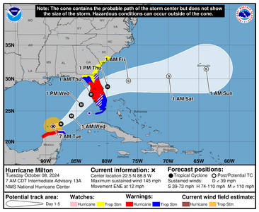
shape
carat
color
clarity

Storm (Hurricane) Milton

There was an eyewall replacement overnight which knocks the speed down some. However its still a major My area is now in blue. Soooo many birds over here! I remember this with Ian, the proliferation of birds.

The yellow guy does develop per the GFS model. But if it does develop, it will follow Milton.

Palm Beach County is still at Level III and I expect we'll stay this way until further notice. Coastal GA and SC... y'all...

The roads are very crowded over here so many are coming to the east side, as its harder to get out of the state altogether.

Some like to go to Orlando and go to Disney during the storms because it really clears out. I think they might be closed considering the track..

Orlando will close Tomorrow 8am.
Tampa will close 9am today


1728390567552.png

This is the 4am discussion but a new one is due out in soon. I'll post this one anyway

992
WTNT44 KNHC 080834
TCDAT4

Hurricane Milton Discussion Number 13
NWS National Hurricane Center Miami FL AL142024
400 AM CDT Tue Oct 08 2024

The structure of Milton has changed significantly overnight. The
pinhole eye seen yesterday has filled and earlier aircraft data
showed a double eyewall structure. More recent microwave images
show only one larger eyewall, and it is clear that Milton is
completing an eyewall replacement cycle. These eyewall replacement
cycles are common in strong hurricanes and often cause the peak
winds to fluctuate, while the wind field generally expands. Based
on the aircraft data from a few hours ago, the initial intensity is
set at 135 kt. Both the NOAA and Air Force Hurricane Hunters are
scheduled to investigate Milton again later this morning.

The major hurricane is beginning to gain latitude, and the latest
initial motion estimate is 075/10 kt. A turn to the northeast with
a slight increase in forward speed is expected later today and
Wednesday as the hurricane moves in the flow between a trough
digging into the Gulf of Mexico and a ridge near the Greater
Antilles. This motion should take the core of Milton to
west-central Florida Wednesday night. After the hurricane passes
Florida, a faster east-northeastward motion is expected within a
more zonal steering flow. Little change was made to the track
forecast through landfall, but this prediction is a little slower
while the system enters and moves over the Atlantic.

Fluctuations in strength due to continued structural changes are
likely during the next day or so while Milton moves across the
central and eastern Gulf of Mexico. An increase in vertical wind
shear will likely cause some weakening before the hurricane reaches
Florida, but there is high confidence that Milton will remain an
extremely dangerous hurricane when it reaches the state. After
landfall, more notable weakening is forecast and Milton is now
expected to become extratropical by day 3 when it is over the
Atlantic. The NHC intensity forecast lies at the high end of the
model guidance in best agreement with the hurricane regional models.

Milton is still a relatively compact hurricane, but the wind field
is expected to continue to grow in size as it approaches Florida.
In fact, the official forecast shows the hurricane and
tropical-storm-force winds roughly doubling in size by the time it
makes landfall. Therefore, damaging winds, life-threatening storm
surge, and heavy rainfall will extend well outside the forecast
cone. It is worth emphasizing that this is a very serious situation
and residents in Florida should closely follow orders from their
local emergency management officials. Milton has the potential to
be one of the most destructive hurricanes on record for west-central
Florida.


Key Messages:

1. Damaging hurricane-force winds and a life-threatening storm surge
with destructive waves are expected across portions of the northern
coast of the Yucatan Peninsula today.

2. Milton is expected to grow in size and remain an extremely
dangerous hurricane when it approaches the west coast of Florida on
Wednesday. A large area of destructive storm surge will occur along
parts of the west coast of Florida. This is an extremely
life-threatening situation and residents in those areas should
follow advice given by local officials and evacuate immediately if
told to do so.

3. Devastating hurricane-force winds are expected along portions of
the west coast of Florida, where a Hurricane Warning is in effect.
Milton is forecast to remain a hurricane as it crosses the Florida
Peninsula and life-threatening hurricane-force winds, especially in
gusts, are expected to spread inland across the peninsula.
Preparations to protect life and property in the warning areas
should be complete by tonight.

4. Areas of heavy rainfall will continue to impact portions of
Florida well ahead of Milton through early Thursday. This rainfall
brings the risk of life-threatening flash, urban and aerial
flooding along with moderate to major river flooding. Flooding will
be exacerbated in areas where coastal and inland flooding combine to
increase the overall threat.


FORECAST POSITIONS AND MAX WINDS

INIT 08/0900Z 22.3N 88.9W 135 KT 155 MPH
12H 08/1800Z 22.9N 87.5W 140 KT 160 MPH
24H 09/0600Z 24.2N 85.8W 135 KT 155 MPH
36H 09/1800Z 26.0N 84.2W 125 KT 145 MPH
48H 10/0600Z 27.6N 82.6W 110 KT 125 MPH...NEAR THE COAST
60H 10/1800Z 28.8N 79.9W 70 KT 80 MPH...OVER WATER
72H 11/0600Z 29.7N 76.5W 60 KT 70 MPH...POST-TROP/EXTRATROP
96H 12/0600Z 30.4N 69.9W 45 KT 50 MPH...POST-TROP/EXTRATROP
120H 13/0600Z 31.5N 63.8W 35 KT 40 MPH...POST-TROP/EXTRATROP

$$
Forecaster Cangialosi
 
No bueno. I just happened to catch an Instagram reel of one of the longtime meteorologists choking up over the impending damage this storm is going to cause. Very worried about those in the Tampa area, and of course the rest of the state. Tampa hospitals are being evacuated, but there aren’t enough beds for everyone. Tampa General Hospital has a storm surge wall that handled Helene ok, but Milton may breech it. Really hoping for no casualties, but not everyone can leave as they don’t have the means to do so.
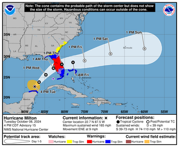
 
No bueno. I just happened to catch an Instagram reel of one of the longtime meteorologists choking up over the impending damage this storm is going to cause. Very worried about those in the Tampa area, and of course the rest of the state. Tampa hospitals are being evacuated, but there aren’t enough beds for everyone. Tampa General Hospital has a storm surge wall that handled Helene ok, but Milton may breech it. Really hoping for no casualties, but not everyone can leave as they don’t have the means to do so.

Most able bodied people can leave and should. As soon as the first executive order was issued October 5 they should have gotten the heck out of dodge. In Zones A and B, areas where they will get extreme surge, areas where they know they flood, they do know the drill, none of this is new here. Hopefully they were smart and those that could leave did.

Most won't leave because "what about my stuff?" If holding on to your stuff worth your life? For some it absolutely is.

I hope Helene scared the crap out of people and they've either left or are leaving. This storm will hit in 48 hours or less.

Free shuttles, Free buses, and free Uber's exist. They are busing people to shelters away from the worst areas and this costs nothing. 95% who stay in these zones choose to do it because they think they can ride it out. Being in a shelter isn't going to be glamorous or super comfortable but they should be safe at least.


I will agree that the ones who are going to have the roughest time will be hospitals, infirm people at home, and nursing homes because they are much more dependent on the operator to do the right thing and you have some very ill people who could die in the process of getting to safety.

But some people even if they're at home don't want to leave that house no matter what, putting the people that care for them at risk.

Then of course, all the first responders who are mandatory to be there.

Unfortunate truth is someone is going to die in this thing. I just hope that deaths are minimal.
 
1728410396283.png

Starting the climb and the winds are climbing as well. Bahamas will get some wind/rain from this storm.
 
There are a ton of people from the west in my area now which makes sense. Some people went to Miami but could not find any rooms, so they're making their way in my area. We've had some rain but not very intense rain and thats always a blessing. My prep work, such as it is, is finished.Tonight, we treat ourselves with Josephs (tiny grocery store near home) Lots of things will not be open tomorrow evening.

The good; there's still gas over here.

1728422111475.png


000
WTNT44 KNHC 082054
TCDAT4

Hurricane Milton Discussion Number 15
NWS National Hurricane Center Miami FL AL142024
400 PM CDT Tue Oct 08 2024

The Air Force Reserve Hurricane Hunters found that Milton's central
pressure had fallen to 923 mb in the last pass they made through
the eye a few hours ago. The satellite presentation has improved
since that time, with a thick ring of cold cloud tops surrounding a
10-mile-wide eye. This pattern yielded a T7.0/140 kt from TAFB,
with several of the objective satellite estimates between 140 and
145 kt. Milton has again become a category 5 hurricane, with
maximum winds estimated to be 145 kt. Another Air Force mission is
entering Milton as we speak.


Milton wobbled a bit to the southeast today, but the longer-term
12-hour motion is east-northeastward (075/8 kt). Milton is forecast
to turn northeastward and begin accelerating later today as it moves
between a trough digging into the Gulf of Mexico and a ridge near
the Greater Antilles. Because of the wobble, the track guidance
has been initialized a bit to the south of where many of the raw
model fields think the hurricane was centered at 1800 UTC, and this
has caused the entire guidance envelope to shift a bit south on
this cycle. It is still critical to remember that even at 36 hours
(around the time of potential landfall), NHC's track forecasts
can be off by an average of 60 n mi, which means we still can't
pinpoint an exact landfall location, especially if additional
wobbles occur in the short term
. After landfall, Milton is
forecast to cross Florida and emerge over the Atlantic waters on
Thursday.

Milton is expected to maintain major hurricane strength while it
moves across the Gulf of Mexico and approaches the west coast of
Florida. Stronger vertical shear is expected to increase in about
24 hours, but even if this causes some weakening, it will likely not
be enough to keep Milton from being an extremely dangerous hurricane
when it reaches shore. Additionally, the first stages of
extratropical transition may be just underway as Milton is reaching
the coast, which could impart some baroclinic energy and slow the
rate of weakening.
The NHC intensity forecast is close to the top
end of the model envelope, which includes the GFS and ECMWF models,
since these models should have a better handle on a potential
positive trough interaction.

Milton's wind field is expected to expand as it approaches Florida.
In fact, the official forecast shows the hurricane and
tropical-storm-force winds roughly doubling in size by the time it
makes landfall. In addition, the stronger-than-normal winds could
occur on the northwest/back side of the storm since Milton will be
interacting with a frontal boundary and beginning extratropical
transition. Damaging winds, life-threatening storm surge, and heavy
rainfall will extend well outside the forecast cone. This is a
very serious situation and residents in Florida should closely
follow orders from their local emergency management officials.
Evacuations and other preparations should be completed today.

Milton has the potential to be one of the most destructive
hurricanes on record for west-central Florida.


Key Messages:

1. A large area of destructive storm surge, with highest
inundations of 10 ft or greater, is expected along a portion of the
west-central coast of the Florida Peninsula. If you are in the
Storm Surge Warning area, this is an extremely life-threatening
situation, and you should evacuate today if ordered by local
officials. There will likely not be enough time to wait to leave on
Wednesday.

2. Devastating hurricane-force winds are expected along portions of
the west coast of Florida, where a Hurricane Warning is in effect.
Milton is forecast to remain a hurricane as it crosses the Florida
Peninsula and life-threatening hurricane-force winds, especially in
gusts, are expected to spread inland across the peninsula.
Preparations to protect life and property, including being ready for
long-duration power outages, should be complete by tonight.

3. Heavy rainfall across the Florida Peninsula through Thursday
brings the risk of catastrophic and life-threatening flash and urban
flooding along with moderate to major river flooding, especially in
areas where coastal and inland flooding combine to increase the
overall flood threat.

4. Tropical storm conditions and a dangerous storm surge with
destructive waves will continue across portions of the northern
coast of the Yucatan Peninsula this evening.


FORECAST POSITIONS AND MAX WINDS

INIT 08/2100Z 22.7N 87.5W 145 KT 165 MPH
12H 09/0600Z 23.8N 86.4W 145 KT 165 MPH
24H 09/1800Z 25.6N 84.7W 130 KT 150 MPH
36H 10/0600Z 27.2N 82.8W 110 KT 125 MPH
48H 10/1800Z 28.1N 80.7W 75 KT 85 MPH...INLAND
60H 11/0600Z 28.6N 77.9W 65 KT 75 MPH...OVER WATER
72H 11/1800Z 29.0N 75.0W 55 KT 65 MPH...POST-TROP/EXTRATROP
96H 12/1800Z 30.6N 68.5W 45 KT 50 MPH...POST-TROP/EXTRATROP
120H 13/1800Z 31.8N 60.0W 40 KT 45 MPH...POST-TROP/EXTRATROP

$$
Forecaster Berg
 
Propane filled
Cars are gassed up (in case there are issues getting gas after the storm)
Potted plants have been taken in
Hurricane Shutters are up...DH felt like it was a little bit overkill but didn't feel like he could sleep Wednesday night if he didn't
put them up.

I'm sure there is something I'm forgetting!

@HS4S_2 You must not be too far from me! Are you on the East Coast?

@Arcadian Lots of people headed south out of Tampa Area according to the highway cams on TV. I guess they're headed
down and across I-75 and making their way north on I-95 until they can find accommodations. Going to be crazy for a couple
of days...but glad most are taking it seriously.

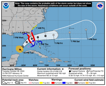
I am on the East Coast. We are between Daytona and St Augustine on the Coast. We are prepared. We are swamped right now. It's so wet.
 
The airlines have added 2000 more seats this evening for those wanting to leave the state

This is one scary hurricane. I’m feeling super anxious and we’re not even affected. I’m scared for you all. Sending so many well wishes your way


Praying for everyone’s safety

@Arcadian @tyty333 @HS4S_2
 
what I know to be true about the east coast. I don't really know if anything is open on the west coast (probably very little will be at this point)

Palm Beach county zone A is activated and we're at level II
https://floridadisaster.maps.arcgis.com/apps/dashboards/e7aa8cb7583241d5a74488576cee4328 thats evacations for all counties.

gas - racetrac is pretty reliable on where there's gas.

In general my area has gas. I've seen people filling up but I've also seen quite a few gas trucks delivering.

Publix in my area will be open if nothing changes,however martin county and up will have early closing hours.


whole foods likewise


Tri Rail, Brightline, Palm Tran will not be running train service until Friday. There will be palm tran bus service to shelters for free in my area.

in fact all counties that are under executive order will offer free transportation to a shelter before things go downhill.

PBI is closing tomorrow at 9pm


Disney is closing tomorrow No theme parks will be open in the greater Orlando area.

Okeechobee county is under boil orders starting Wednesday.

Miami and Fort Lauderdale airports are currently open.

Hotels are not plentiful as they were in my neck of the woods and will likely be all booked up tonight or tomorrow.
 
Last edited:
1728442520422.png


000
WTNT44 KNHC 090242
TCDAT4

Hurricane Milton Discussion Number 16
NWS National Hurricane Center Miami FL AL142024
1000 PM CDT Tue Oct 08 2024

NOAA and Air Force Hurricane Hunter aircraft have been investigating
Milton again this evening, providing a number of center fixes,
flight-level wind data, dropsonde measurements, and other valuable
observations. Data from the aircraft confirmed that the hurricane
had regained category 5 intensity, with maximum winds near 145 kt
and the central pressure as low as 902 mb. More recent aircraft
observations showed that the central pressure had risen somewhat, so
the advisory intensity is adjusted slightly down, to 140 kt. This
is also consistent with the latest subjective Dvorak intensity
estimates from both TAFB and SAB.


Center fixes from the aircraft and satellite images indicate that
Milton's heading is gradually turning toward the left and the
initial motion estimate is now about 055/10 kt. The system is being
steered by the flow between a trough digging over the Gulf of Mexico
and a ridge near the Greater Antilles. Milton should move
northeastward on Wednesday with a slight increase in forward speed,
with the center of the hurricane reaching the Florida Gulf coast in
24 hours or so. Thereafter, the system should turn
east-northeastward to eastward and move over the southwestern
Atlantic off the southeast U.S. coast. The official track forecast
is very similar to the previous one, and is generally a little north
of the model trackers, but follows the actual model predicted
cyclone center locations. This is close to a blend of the latest
GFS and ECMWF model solutions. Again, it is critical to remember
that even at 24 hours out, it is still not possible to pinpoint an
an exact landfall location.


Milton is expected to maintain major hurricane strength while it
moves across the eastern Gulf of Mexico and approaches the west
coast of Florida. Although an expected increase in vertical wind
shear should cause some weakening, Milton is expected to still be an
extremely dangerous major hurricane when it reaches shore. Also,
the first stages of extratropical transition may be just underway as
Milton reaches the coast, which could impart some baroclinic energy
and slow the rate of weakening.
The NHC intensity forecast is near
the upper side of the intensity model guidance. After Milton moves
over the Atlantic, the global models show the system becoming
embedded within a frontal zone, so the official forecast shows the
system becoming extratropical by 72 hours.

Milton's wind field is expected to grow considerably in size by the
time the center moves over Florida. In addition, a large region of
tropical storm and hurricane force winds could occur on the
northwest/back side of the storm since Milton will be interacting
with a frontal boundary and beginning extratropical transition.

Damaging winds, life-threatening storm surge, and heavy rainfall
will extend well outside the forecast cone. This is a very serious
situation and residents in Florida should closely follow orders from
their local emergency management officials. Evacuations and other
preparations should be completed tonight. Milton has the potential
to be one of the most destructive hurricanes on record for
west-central Florida.


Key Messages:

1. A large area of destructive storm surge, with highest inundations
of 10 ft or greater, is expected along a portion of the west-central
coast of the Florida Peninsula. If you are in the Storm Surge
Warning area, this is an extremely life-threatening situation, and
you should evacuate as soon as possible if ordered by local
officials. There will likely not be enough time to wait to leave on
Wednesday.

2. Devastating hurricane-force winds are expected along portions of
the west coast of Florida, where a Hurricane Warning is in effect.
Milton is forecast to remain a hurricane while it crosses the
Florida Peninsula and life-threatening hurricane-force winds,
especially in gusts, are expected to spread inland across the
peninsula. Preparations to protect life and property, including
being ready for long-duration power outages, should be rushed to
completion.

3. Heavy rainfall across the Florida Peninsula through Thursday
brings the risk of catastrophic and life-threatening flash and urban
flooding along with moderate to major river flooding, especially in
areas where coastal and inland flooding combine to increase the
overall flood threat.


FORECAST POSITIONS AND MAX WINDS

INIT 09/0300Z 23.4N 86.5W 140 KT 160 MPH
12H 09/1200Z 24.7N 85.3W 135 KT 155 MPH
24H 10/0000Z 26.5N 83.6W 115 KT 130 MPH
36H 10/1200Z 27.9N 81.4W 75 KT 85 MPH...INLAND
48H 11/0000Z 28.5N 78.8W 70 KT 80 MPH...OVER WATER
60H 11/1200Z 29.0N 75.5W 65 KT 75 MPH
72H 12/0000Z 29.4N 72.0W 55 KT 65 MPH...POST-TROP/EXTRATROP
96H 13/0000Z 30.4N 65.0W 45 KT 50 MPH...POST-TROP/EXTRATROP
120H 14/0000Z 31.5N 57.9W 40 KT 45 MPH...POST-TROP/EXTRATROP
 
Waffle Houses in the storm path are closing. Thats serious business because they never or rarely close.

For those who don't know, Just do a google on 'Waffle House Index' and you'll understand.

Storm is moving quickly but there's still an expectation of a Cat 4 at landfall.

1728475558093.png


000
WTNT34 KNHC 091147
TCPAT4

BULLETIN
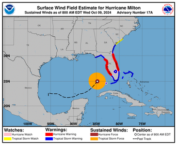
Hurricane Milton Intermediate Advisory Number 17A
NWS National Hurricane Center Miami FL AL142024
800 AM EDT Wed Oct 09 2024

...WINDS WILL BEGIN TO INCREASE ALONG THE WEST COAST OF FLORIDA BY
THIS AFTERNOON...
...PREPARATIONS, INCLUDING EVACUATION IF TOLD TO DO SO, SHOULD BE
RUSHED TO COMPLETION THIS MORNING...


SUMMARY OF 800 AM EDT...1200 UTC...INFORMATION
----------------------------------------------
LOCATION...25.0N 84.8W
ABOUT 120 MI...195 KM W OF THE DRY TORTUGAS
ABOUT 250 MI...405 KM SW OF TAMPA FLORIDA
MAXIMUM SUSTAINED WINDS...155 MPH...250 KM/H
PRESENT MOVEMENT...NE OR 40 DEGREES AT 16 MPH...26 KM/H
MINIMUM CENTRAL PRESSURE...915 MB...27.02 INCHES


WATCHES AND WARNINGS
--------------------
CHANGES WITH THIS ADVISORY:

None.

SUMMARY OF WATCHES AND WARNINGS IN EFFECT:

A Storm Surge Warning is in effect for...
* Florida west coast from Flamingo northward to Yankeetown,
including Charlotte Harbor and Tampa Bay
* Sebastian Inlet Florida to Altamaha Sound Georgia, including the
St. Johns River

A Hurricane Warning is in effect for...
* Florida west coast from Bonita Beach northward to Suwannee River,
including Tampa Bay
* Florida east coast from the St. Lucie/Martin County Line northward
to Ponte Vedra Beach

A Storm Surge Watch is in effect for...
* North of Altamaha Sound Georgia to Edisto Beach South Carolina

A Hurricane Watch is in effect for...
* Dry Tortugas
* Lake Okeechobee
* Florida west coast from Chokoloskee to south of Bonita Beach
* Florida east coast north of Ponte Vedra Beach to the mouth of the
St. Marys River
* Florida east coast from the St. Lucie/Martin County Line to the
Palm Beach/Martin County Line

A Tropical Storm Warning is in effect for...
* Florida Keys, including Dry Tortugas and Florida Bay
* Lake Okeechobee
* Florida west coast from Flamingo to south of Bonita Beach
* Florida west coast from north of Suwanee River to Indian Pass
* Florida east coast south of the St. Lucie/Martin County Line to
Flamingo
* North of Ponte Vedra Beach Florida to the Savannah River
* Extreme northwestern Bahamas, including Grand Bahama Island, the
Abacos, and Bimini

A Tropical Storm Watch is in effect for...
* North of the Savannah River to South Santee River South
Carolina

A Storm Surge Warning means there is a danger of life-threatening
inundation, from rising water moving inland from the coastline,
during the next 36 hours in the indicated locations. For a
depiction of areas at risk, please see the National Weather
Service Storm Surge Watch/Warning Graphic, available at
hurricanes.gov. This is a life-threatening situation. Persons
located within these areas should take all necessary actions to
protect life and property from rising water and the potential for
other dangerous conditions. Promptly follow evacuation and other
instructions from local officials.

A Hurricane Warning means that hurricane conditions are expected
somewhere within the warning area. A warning is typically issued
36 hours before the anticipated first occurrence of
tropical-storm-force winds, conditions that make outside
preparations difficult or dangerous. Preparations to protect life
and property should be rushed to completion.

A Tropical Storm Warning means that tropical storm conditions are
expected somewhere within the warning area within 36 hours.

A Storm Surge Watch means there is a possibility of life-
threatening inundation, from rising water moving inland from the
coastline, in the indicated locations during the next 48 hours.
For a depiction of areas at risk, please see the National Weather
Service Storm Surge Watch/Warning Graphic, available at
hurricanes.gov.

A Hurricane Watch means that hurricane conditions are possible
within the watch area. A watch is typically issued 48 hours
before the anticipated first occurrence of tropical-storm-force
winds, conditions that make outside preparations difficult or
dangerous.

A Tropical Storm Watch means that tropical storm conditions are
possible within the watch area, generally within 48 hours.

For storm information specific to your area in the United
States, including possible inland watches and warnings, please
monitor products issued by your local National Weather Service
forecast office. For storm information specific to your area
outside of the United States, please monitor products issued by
your national meteorological service.


DISCUSSION AND OUTLOOK
----------------------
At 800 AM EDT (1200 UTC), the eye of Hurricane Milton was located
near latitude 25.0 North, longitude 84.8 West. Milton is moving
toward the northeast near 16 mph (26 km/h). A northeastward motion
is expected through tonight. A turn toward the east-northeast and
east is expected on Thursday and Friday. On the forecast track, the
center of Milton will move across the eastern Gulf of Mexico today,
make landfall along the west-central coast of Florida late tonight
or early Thursday morning, and move off the east coast of Florida
over the western Atlantic Ocean Thursday afternoon.

Maximum sustained winds are near 155 mph (250 km/h) with higher
gusts. Milton is a category 4 hurricane on the Saffir-Simpson
Hurricane Wind Scale. Milton is expected to remain an extremely
dangerous major hurricane when it reaches the west-central coast of
Florida tonight.

Hurricane-force winds extend outward up to 30 miles (45 km) from
the center and tropical-storm-force winds extend outward up to 125
miles (205 km).

The minimum central pressure based on NOAA and Air Force Reserve
Hurricane Hunter data is 915 mb (27.02 inches).


HAZARDS AFFECTING LAND
----------------------
Key Messages for Milton can be found in the Tropical Cyclone
Discussion under AWIPS header MIATCDAT4 and WMO header WTNT44 KNHC
and on the web at hurricanes.gov/text/MIATCDAT4.shtml

STORM SURGE: The combination of a dangerous storm surge and the
tide will cause normally dry areas near the coast to be flooded by
rising waters moving inland from the shoreline. The water could
reach the following heights above ground somewhere in the indicated
areas if the peak surge occurs at the time of high tide...

Anna Maria Island, FL to Boca Grande, FL...10-15 ft
Anclote River, FL to Anna Maria Island, FL...8-12 ft
Tampa Bay...8-12 ft
Boca Grande, FL to Bonita Beach, FL...8-12 ft
Charlotte Harbor...8-12 ft
Bonita Beach, FL to Chokoloskee, FL...5-8 ft
Aripeka, FL to Anclote River, FL...4-7 ft
Chokoloskee, FL to Flamingo, FL...3-5 ft
Sebastian Inlet, FL to Altamaha Sound, GA...3-5 ft
Altamaha Sound, GA to Edisto Beach, SC...2-4 ft
Yankeetown, FL to Aripeka, FL...2-4 ft
Dry Tortugas...2-4 ft
St. Johns River...2-4 ft

The deepest water will occur along the immediate coast near and to
the south of the landfall location, where the surge will be
accompanied by large and dangerous waves. Surge-related flooding
depends on the relative timing of the surge and the tidal cycle,
and can vary greatly over short distances. For information
specific to your area, please see products issued by your local
National Weather Service forecast office.

For a complete depiction of areas at risk of storm surge
inundation, please see the National Weather Service Peak Storm
Surge Graphic, available at
hurricanes.gov/graphics_at4.shtml?peakSurge.

RAINFALL: Rainfall amounts of 6 to 12 inches, with localized totals
up to 18 inches, are expected across central to northern portions of
the Florida Peninsula through Thursday. This rainfall brings the
risk of catastrophic and life-threatening flash and urban flooding,
along with moderate to major river flooding.

For a complete depiction of forecast rainfall associated with
Hurricane Milton, please see the National Weather Service Storm
Total Rainfall Graphic, available at
hurricanes.gov/graphics_at4.shtml?rainqpf and the Flash Flood Risk
graphic at hurricanes.gov/graphics_at4.shtml?ero.

WIND: Hurricane conditions are expected in the hurricane warning
area across Florida beginning this evening through early Thursday
and are possible in the hurricane watch area on Thursday. Tropical
storm conditions are expected to begin in the warning area on the
west coast of Florida around midday, spreading across the peninsula
and reaching the east coast tonight. Tropical storm conditions are
expected to begin in the warning area on the east coast of Florida
tonight and along the Georgia coast on Thursday.

Tropical storm conditions are expected in portions of the
northwestern Bahamas on Thursday.

Tropical storm conditions are possible within the watch area
on the South Carolina coast on Thursday.

TORNADOES: Several tornadoes are likely today and tonight across
parts of central and southern Florida.

SURF: Swells generated by Milton are expected to continue to affect
much of the Gulf Coast and will increase along the southeastern U.S.
coast during the next day or two. These swells are likely to cause
life-threatening surf and rip current conditions. Please consult
products from your local weather office.
 
Palm Beach County is under Tornado watch. So its starting y'all. Gonna be a hell of a day.
 
I will start putting the live channels here for those who might be interested.

NBC-2 Live Stream from WBBH-TV in Ft. Myers, Florida

WPBF 25 News Treasure Coast
 
I am on the East Coast. We are between Daytona and St Augustine on the Coast. We are prepared. We are swamped right now. It's so wet.

I am south of you but north of Arcadian. We're right in the bullseye for the East Coast at the moment. We're already pretty drenched
here too.
 
I am south of you but north of Arcadian. We're right in the bullseye for the East Coast at the moment. We're already pretty drenched
here too.

We have some actual sunlight down here. Winds are coming in from the south and definitely unlike yesterday were it was very still and quiet, they are making the small bushes dance in front of my house.
 
I have family and friends throughout Florida, from Dunedin to Miami. Everyone in Lake Okeechobee and north have evacuated; those in Ft. Lauderdale and south are staying.

In many central and north FL areas, there are thousands of mobile homes and RVs. There's a mix of older home and camping sites (what most of us think of) and luxury resorts, where people have dedicated garages for expensive motor homes. I hope they evacuated.

Arcadian, first, thanks for your info. I'm fairly sure I know people who live very close to you. They have hurricane shutters and a generator, so are staying.

To be clear, I don't know where Arcadian lives, just recognize the vicinity!

One thing about hurricane shutters is that being inside with them in place is surprisingly scary in and of itself! Total pitch darkness.

And yes, Waffle House closing is a big deal!
 
Last edited:
I am south of you but north of Arcadian. We're right in the bullseye for the East Coast at the moment. We're already pretty drenched
here too.

My son is a Firefighter right in the eye where it exits the East Coast. He will be working until Friday. They expect to have a very busy few days.
 
I have family and friends throughout Florida, from Dunedin to Miami. Everyone in Lake Okeechobee and north have evacuated; those in Ft. Lauderdale and south are staying.

In many central and north FL areas, there are thousands of mobile homes and RVs. There's a mix of older home and camping sites (what most of us think of) and luxury resorts, where people have dedicated garages for expensive motor homes. I hope they evacuated.

Arcadian, first, thanks for your info. I'm fairly sure I know people who live very close to you. They have hurricane shutters and a generator, so are staying.

To be clear, I don't know where Arcadian lives, just recognize the vicinity!

One thing about hurricane shutters is that being inside with them in place is surprisingly scary in and of itself! Total pitch darkness.

And yes, Waffle House closing is a big deal!

My house was made for hurricanes in mind. I have a total of 8 windows but they are impact rated and I don't board up for that reason alone. My only worry is ground saturation at this point but thats everywhere here.

My neighborhood is full, no one has left. Called over at publix just to check and they're open as long as they can stay open (otherwise regular hours)

Even the car wash by the freeway was open today (I don't get that part but OK...)

I'm glad your family/friends evacuated to safer areas.
 
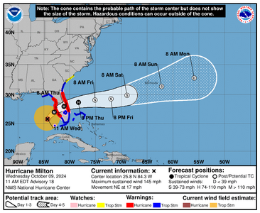
The track at this point is pretty set. There may be a north or south wobble but it won't make a whole lot of difference. Wind speeds are going down, pressure is rising. Those are the good things. The bad is the wind field expansion which is visible on this image.

1728486310945.png


000
WTNT44 KNHC 091456
TCDAT4

Hurricane Milton Discussion Number 18
NWS National Hurricane Center Miami FL AL142024
1100 AM EDT Wed Oct 09 2024

Milton's structure has begun to change due to the onset of strong
southwesterly shear, which UW-CIMSS is analyzing to be 30-35 kt.
The cloud canopy has become more asymmetric with dry air
infiltrating the western side of the circulation, and the eye has
also become cloud filled. The NOAA and Air Force Reserve
Hurricane Hunters observed that the eye is open to the south, and a
very recent dropsonde indicates that the minimum pressure is up to
931 mb. Milton's intensity is therefore set at 125 kt on this
advisory.

Deep-layer shear is expected to increase further today and this
evening, and continued weakening is anticipated. However, since
Milton only has another 12 hours or so over water, it is expected
to still be a major hurricane when it makes landfall tonight. The
NHC intensity forecast lies between the statistical-dynamical models
and the consensus aids at 12 hours, meaning that Milton is likely
to be a category 3 or 4 strength at landfall.
A slow decay in the
winds is expected after landfall, but Milton is anticipated to move
off the east coast of Florida on Thursday still as a hurricane. On
another note, Milton is expected to begin interacting with a front
later this evening, which is likely to cause the wind field to
expand on the hurricane's northwestern side. This will likely
cause very strong, gusty winds to occur even to the north of where
Milton makes landfall.

Milton is moving quickly toward the northeast (035/15 kt). The
track models insist that the hurricane will continue to move
northeastward but slow down through the rest of today, with a turn
toward the east-northeast occurring overnight. The NHC track
forecast maintains continuity with the previous predictions, lying
near the northern boundary of the guidance envelope and close to
where the raw model fields bring the center onshore.

We would like to emphasize that Milton's exact landfall location is
not possible to predict even at this time, particularly if the
hurricane wobbles during the day and into this evening. Even at
12-24 hours, NHC's track forecasts can be off by an average of 20-30
nm.
Since storm surge forecasts are highly sensitive to the exact
track, this means that the realized storm surge heights across the
Tampa Bay region and south may vary widely, and there will likely be
a noticeable gradient of surge heights to the north of the landfall
location. However, the risk of devastating storm surge still exists
across much of the west-central and southwest coast of Florida given
the size of the storm and the uncertainties in exactly where
landfall will occur.

Finally, damaging winds, life-threatening storm surge, and heavy
rainfall will extend well outside the forecast cone. This is a very
serious situation and residents in Florida should closely follow
orders from their local emergency management officials. Evacuations
and other preparations should be completed over the next couple of
hours.


Key Messages:

1. A large area of destructive storm surge, with highest inundations
of 10 ft or greater, is expected along a portion of the west-central
coast of the Florida Peninsula. If you are in the Storm Surge
Warning area, this is an extremely life-threatening situation. The
time to evacuate, if told to do so by local officials, is quickly
coming to a close.

2. Devastating hurricane-force winds are expected along portions of
the west coast of Florida, where a Hurricane Warning is in effect.
Milton is forecast to remain a hurricane while it crosses the
Florida Peninsula and life-threatening hurricane-force winds,
especially in gusts, are expected to spread inland across the
peninsula. Preparations to protect life and property, including
being ready for long-duration power outages, should be rushed to
completion.

3. Heavy rainfall across the Florida Peninsula through Thursday
brings the risk of catastrophic and life-threatening flash and urban
flooding along with moderate to major river flooding, especially in
areas where coastal and inland flooding combine to increase the
overall flood threat.


FORECAST POSITIONS AND MAX WINDS

INIT 09/1500Z 25.8N 84.3W 125 KT 145 MPH
12H 10/0000Z 27.0N 83.0W 110 KT 125 MPH
24H 10/1200Z 28.0N 81.1W 75 KT 85 MPH...INLAND
36H 11/0000Z 28.7N 78.3W 65 KT 75 MPH...OVER WATER
48H 11/1200Z 29.1N 75.1W 55 KT 65 MPH...POST-TROP/EXTRATROP
60H 12/0000Z 29.3N 72.0W 50 KT 60 MPH...POST-TROP/EXTRATROP
72H 12/1200Z 29.9N 68.9W 45 KT 50 MPH...POST-TROP/EXTRATROP
96H 13/1200Z 31.4N 62.2W 35 KT 40 MPH...POST-TROP/EXTRATROP
120H 14/1200Z 32.8N 55.9W 30 KT 35 MPH...POST-TROP/EXTRATROP

$$
Forecaster Berg
 
My son is a Firefighter right in the eye where it exits the East Coast. He will be working until Friday. They expect to have a very busy few days.

I imagine he will be busy...tell him to stay safe out there!
 
Live, this is what we're dealing with right now

 
1728497669272.png
 
I can't imagine being in those areas and staying.......
 
Thinking about everyone in the path of this monster and hoping everyone stays safe!
 
Thinking of those affected by Hurricane Milton.

DK :confused2:
 
Weve had ton of tornado warnings. and of course there are more coming. St. Lucie Sheriffs building was hit by a tornado as well.

There was a tornado just west of me moving north, scared the crap out of us.
 
GET 3 FREE HCA RESULTS JOIN THE FORUM. ASK FOR HELP
Top