We lost power around 5 pm yesterday. Winds started up around 4, got worse as expected and around 2 am, it stopped like a light switch. No Internet either at our house on cell networks. We are out for food. No water pressure for showers either. Some slight roof damage, nothing awful that I see. Loads of very large oaks sucked up by the roots and split in half, even in our neighborhood but we were lucky. Formerly straight palms in our yard are now bent. We will have the roof and trees checked after people with bad damage get help first.
You are using an out of date browser. It may not display this or other websites correctly.
You should upgrade or use an alternative browser.
You should upgrade or use an alternative browser.
Hurricane season: We got some stuff to watch (FL, Gulf, Eastern US)
- Thread starter Arcadian
- Start date
- Joined
- Sep 17, 2008
- Messages
- 9,434
We lost power around 5 pm yesterday. Winds started up around 4, got worse as expected and around 2 am, it stopped like a light switch. No Internet either at our house on cell networks. We are out for food. No water pressure for showers either. Some slight roof damage, nothing awful that I see. Loads of very large oaks sucked up by the roots and split in half, even in our neighborhood but we were lucky. Formerly straight palms in our yard are now bent. We will have the roof and trees checked after people with bad damage get help first.
I'm glad that you're doing OK and damage sound minimal. Will you be able to get some place that has power and at least some water pressure? knowing how bad it feels without a shower and AC (but it was somewhat cool today) its a drag.
I'm glad that you're doing OK and damage sound minimal. Will you be able to get some place that has power and at least some water pressure? knowing how bad it feels without a shower and AC (but it was somewhat cool today) its a drag.
Thanks - the power and water stinks! Glad you are doing ok. Thanks for all the updates too.
I went into the pool and washed my hair there.
- Joined
- Dec 17, 2008
- Messages
- 28,276
The weirdest thing happened here...the temperature dropped to 66 degrees. Thats at least a 15 degree drop from this morning.
My DH said the hurricane is cycling some of the cooler air from GA/SC down here. I don't know if that's true or not.
Glad you are ok @elizat. Must have been a scary night. I hate when they hit at night.
My DH said the hurricane is cycling some of the cooler air from GA/SC down here. I don't know if that's true or not.
Glad you are ok @elizat. Must have been a scary night. I hate when they hit at night.
- Joined
- Sep 17, 2008
- Messages
- 9,434
The weirdest thing happened here...the temperature dropped to 66 degrees. Thats at least a 15 degree drop from this morning.
My DH said the hurricane is cycling some of the cooler air from GA/SC down here. I don't know if that's true or not.
Glad you are ok @elizat. Must have been a scary night. I hate when they hit at night.
Its quite cool down here at 73 degrees. The windfield is enormous on this storm though it absolutely has dry air being wrapped into it. Even so there's the steering high from the west providing some of that cooler air (thankfully!)
Last edited:
- Joined
- Jun 8, 2008
- Messages
- 56,742
- Joined
- Jul 24, 2003
- Messages
- 3,075
RetroQT
Brilliant_Rock
- Joined
- Oct 14, 2018
- Messages
- 732
We made it through with no damage. It had shifted so far East that all we experienced was some light rain and occasional gusts of wind. Clean up is pretty much some twigs and leaves.
We know how lucky we got, for sure! I hope all of our PSers that remained in the path are all safe and secure, as are their homes.
- Joined
- Sep 17, 2008
- Messages
- 9,434
The good: Ian stayed at 85MPH. the bad. well...look at this image.
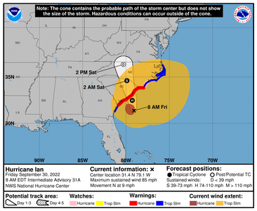
Although the eye is not big, the windfield is! I'm hoping and praying you guys don't get the damage FL did, but y'all have a lot of trees up there with leaves on them still.

Although the eye is not big, the windfield is! I'm hoping and praying you guys don't get the damage FL did, but y'all have a lot of trees up there with leaves on them still.
25
WTNT44 KNHC 300847
TCDAT4
Hurricane Ian Discussion Number 31
NWS National Hurricane Center Miami FL AL092022
500 AM EDT Fri Sep 30 2022
Ian continues to display hybrid tropical/extratropical
characteristics, and the satellite appearance is increasingly
taking on the pattern of an occluded low. Some deep convection has
still been developing just northwest of the center, however. Based
on SFMR measurements from an earlier Air Force Reserve Hurricane
Hunter aircraft, the initial intensity is 75 kt, and as of right
now, all sustained hurricane-force winds are located within the
western semicircle.
The motion of Ian's center has been somewhat discontinuous during
the past 6 to 12 hours, with multiple swirls apparently rotating
around a common center. The smooth motion is toward the
north-northeast, or 015/9 kt, although Ian should turn northward
very soon. A turn toward the north-northwest is expected by tonight
as Ian moves around and merges with a shortwave trough over the
southeastern United States. Track models appear to have stabilized,
and all show Ian's center crossing the coast of South Carolina this
afternoon, and then moving across eastern South Carolina and central
North Carolina tonight and on Saturday. Since there has been no
noticeable shift in the guidance on this cycle, the new NHC forecast
essentially lies right on top of the previous prediction.
Although very strong southwesterly shear is affecting Ian, the
hurricane is likely deriving its energy from a mixture of the warm
waters of the Gulf Stream and favorable interaction with the
southeastern U.S. shortwave trough. Those two influences should
continue today, and no significant changes to the intensity are
expected up until Ian's anticipated landfall this afternoon, which
is generally in line with the SHIPS and LGEM guidance. It should be
noted that hurricane-force winds are expected to develop within the
eastern semicircle soon, particularly as Ian begins to move faster
toward the north. After landfall, fast weakening is expected, and
Ian is also forecast to become fully extratropical by 36 hours, if
not a little sooner. The extratropical low is then forecast to
dissipate near the North Carolina/Virginia border by Saturday night.
One additional note: a frontal boundary that extends to the
northeast of Ian is expected to shift inland later today, and the
extensive area of tropical-storm-force winds shown in the
northeastern quadrant is forecast to contract considerably later
today and tonight.
Key Messages:
1. There is a danger of life-threatening storm surge today along the
coasts of northeast Florida, Georgia, and the Carolinas within the
Storm Surge Warning areas. Residents in these areas should follow
any advice given by local officials.
2. Hurricane-force winds are expected along the coasts of South
Carolina and southeastern North Carolina within the Hurricane
Warning area by this afternoon. Hurricane conditions are possible
in North Carolina within the Hurricane Watch area by this afternoon.
Preparations should be rushed to completion.
3. Ongoing major to record river flooding will continue through next
week across portions of central Florida. Considerable flooding is
expected through today across portions of coastal and northeast
South Carolina. Locally considerable flooding is possible across
portions of North Carolina and southern Virginia through today.
FORECAST POSITIONS AND MAX WINDS
INIT 30/0900Z 30.8N 79.1W 75 KT 85 MPH
12H 30/1800Z 32.5N 79.3W 75 KT 85 MPH
24H 01/0600Z 34.6N 79.9W 45 KT 50 MPH...INLAND
36H 01/1800Z 36.3N 80.3W 30 KT 35 MPH...POST-TROP/EXTRATROP
48H 02/0600Z...DISSIPATED
$$
Forecaster Berg
Mrs_Strizzle
Brilliant_Rock
- Joined
- Jun 14, 2018
- Messages
- 1,601
So glad everyone is ok!
We are in GA and got lots of evacuees staying in our properties. We got lots of wind and dropping Temps too. I wanted my jacket yesterday afternoon! More evacuees came last night from SC. Hoping damage there doesn't get too extensive. We have several friends that own oyster farms on the coast that we are praying for not just their homes but their livelihoods.
We are in GA and got lots of evacuees staying in our properties. We got lots of wind and dropping Temps too. I wanted my jacket yesterday afternoon! More evacuees came last night from SC. Hoping damage there doesn't get too extensive. We have several friends that own oyster farms on the coast that we are praying for not just their homes but their livelihoods.
- Joined
- Sep 17, 2008
- Messages
- 9,434
- Joined
- Sep 17, 2008
- Messages
- 9,434
In eastern NC and we just started getting rain and winds about 4a.m. this morning, had to drive in to work in this mess, not fun.
I worry about you guys up there because there's so many trees. Hoping that Ian will not be too much of a problem!
- Joined
- Sep 17, 2008
- Messages
- 9,434
If you have roof damage an you were hit, this is a great resource to use (it will help you stay in your home (please pass the information to others in your community!)
Free and for those who are in disaster areas. Your federal tax dollars at work!!
Looks like Ian will be ashore shortly. Its gonna be realtime from here.
Power outage map

 poweroutage.us
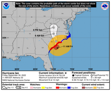
Free and for those who are in disaster areas. Your federal tax dollars at work!!
Looks like Ian will be ashore shortly. Its gonna be realtime from here.
Power outage map

United States Power Outage Map

959
WTNT44 KNHC 301455
TCDAT4
Hurricane Ian Discussion Number 32
NWS National Hurricane Center Miami FL AL092022
1100 AM EDT Fri Sep 30 2022
Satellite images show that Ian has re-developed deep convection
near the center, with frontal features away from the core of the
cyclone. Additionally, a primitive eyewall has formed around about
half of the circulation. An Air Force Reserve Hurricane Hunter
aircraft recently found peak flight-level winds of 80 kt and SFMR
winds of 72 kt. Radar data is also showing winds of up to 85 kt
around 10 thousand feet, with hurricane-force winds now in the
northeastern quadrant. These values support the initial wind speed
of 75 kt. NOAA buoy 41004 near the center recently reported a
minimum pressure of 981 mb with some wind, which supports the
advisory value.
Ian is now moving faster to the north, around 12 kt, and should
continue to accelerate to the north-northwest later today due to
a shortwave trough over the southeastern United States. The new
forecast is adjusted a bit to the east, but should still lead to a
landfall in South Carolina this afternoon. Little change in
intensity is expected before Ian makes landfall, due to competing
influences of strong shear versus baroclinic forcing from the trough
over water waters. Ian should rapidly transition into an
extratropical low tonight after landfall, and dissipate by Saturday
night.
It should be emphasized that dangerous winds and life-threatening
storm surge should rapidly increase during the next few hours in
the Storm Surge and Hurricane Warning areas due to Ian moving faster
toward the coast.
Key Messages:
1. There is a danger of life-threatening storm surge today along the
coasts of the Carolinas within the Storm Surge Warning areas.
2. Hurricane-force winds are expected along the coasts of South
Carolina and southeastern North Carolina within the Hurricane
Warning area soon. Hurricane conditions are possible in North
Carolina within the Hurricane Watch area by this afternoon.
Preparations should be rushed to completion.
3. Ongoing major-to-record river flooding will continue through
next week across portions of central Florida. Considerable flooding
is expected today across portions of coastal and northeast South
Carolina, coastal North Carolina and southeast Virginia. Locally
considerable flooding is possible across portions of northwest North
Carolina and southern Virginia today into early Saturday.
FORECAST POSITIONS AND MAX WINDS
INIT 30/1500Z 32.4N 79.0W 75 KT 85 MPH
12H 01/0000Z 34.1N 79.4W 50 KT 60 MPH...POST-TROP/EXTRATROP
24H 01/1200Z 36.0N 80.0W 25 KT 30 MPH...POST-TROP/EXTRATROP
36H 02/0000Z 37.5N 80.0W 15 KT 15 MPH...POST-TROP/EXTRATROP
48H 02/1200Z...DISSIPATED
$$
Forecaster Blake
- Joined
- Jun 26, 2007
- Messages
- 9,012
Thanks for asking @missy
My calls will not go through, but my sister was able to contact Dad this morning. Mom and dad are both fine, the generator is working, and he already has someone fixing his fence.
Part of the roof was damaged, but I'm sure he'll get that fixed later.
I was very relieved to hear this good news.
- Joined
- Sep 17, 2008
- Messages
- 9,434
I'm glad your parents are OK!Thanks for asking @missy
My calls will not go through, but my sister was able to contact Dad this morning. Mom and dad are both fine, the generator is working, and he already has someone fixing his fence.
Part of the roof was damaged, but I'm sure he'll get that fixed later.
I was very relieved to hear this good news.
- Joined
- Jun 8, 2008
- Messages
- 56,742
Thanks for asking @missy
My calls will not go through, but my sister was able to contact Dad this morning. Mom and dad are both fine, the generator is working, and he already has someone fixing his fence.
Part of the roof was damaged, but I'm sure he'll get that fixed later.
I was very relieved to hear this good news.
So happy for you! The fact your loved ones are safe and sound… That’s everything
Mrs_Strizzle
Brilliant_Rock
- Joined
- Jun 14, 2018
- Messages
- 1,601
This will be Ian's third landfall. Def. another I-name retired. (I really don't like I named storms)
We were out of power for 6 days after Irma! In Middle Georgia. The 100 year old oaks in my neighborhood said their goodbyes. That was a horrible storm too.
Thanks for asking @missy
My calls will not go through, but my sister was able to contact Dad this morning. Mom and dad are both fine, the generator is working, and he already has someone fixing his fence.
Part of the roof was damaged, but I'm sure he'll get that fixed later.
I was very relieved to hear this good news.
Probably cell tower emergency service only. Ours went down and just started to come back today. Hopefully you can actually speak soon!
The weirdest thing happened here...the temperature dropped to 66 degrees. Thats at least a 15 degree drop from this morning.
My DH said the hurricane is cycling some of the cooler air from GA/SC down here. I don't know if that's true or not.
Glad you are ok @elizat. Must have been a scary night. I hate when they hit at night.
It was lovely while it lasted. Back to the mid 80's and hot. It was nice, but not for the reason why.
RetroQT
Brilliant_Rock
- Joined
- Oct 14, 2018
- Messages
- 732
It was lovely while it lasted. Back to the mid 80's and hot. It was nice, but not for the reason why.
Yeah, it’s gorgeous here today. A beautiful 75° day. The kind of day where you can comfortably wear shorts or pants (which is how I gauge the perfect temperature). But it’s back up to mid-high 80s tomorrow.
- Joined
- Sep 17, 2008
- Messages
- 9,434
I'm a bit weird but I'm OK for mid 80's when there's a breeze. Next 2 days at 85 degrees is amazing to me. But, we were getting 90+ and ridiculously stifling humidity that felt like a blanket. If the humidity stays down (lets hope!) it will be tolerable for most.It was lovely while it lasted. Back to the mid 80's and hot. It was nice, but not for the reason why.
- Joined
- Sep 17, 2008
- Messages
- 9,434
- Joined
- Aug 12, 2005
- Messages
- 19,549
I hope everyone is doing OK today and hopefully just in cleanup mode.
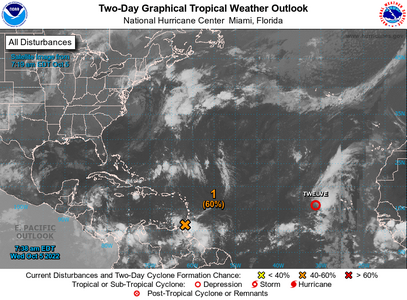
Unfortunately it is still hurricane season and I'm watching a spot. lets see what happens as they're saying 70% and GFS is sniffing out something.
WHAT SPOT
- Joined
- Sep 17, 2008
- Messages
- 9,434
WHAT SPOT
I swear its only a small spot. But its over 14 days out so it could well dissipate and be a nothing burger. However, its in an area ripe for development and thats why I'm just watching it. These last few model runs has it running into Mexico.
- Joined
- Sep 17, 2008
- Messages
- 9,434
Well, should I just start a new thread? OK Maybe I won't, you guys let me know.
twelve is going west then probably north. but 60%? is questionable and there's my little clump of storms I've been watching.
Anyway don't freak out because it could dissipate. It could form true, but not worth the freakout now.
And while everyone is still concentrating on Ian (which was absolutely terrible and effects are still being felt with all the water inland) Paradise Beach still hasn't recovered from Hurricane Michael. Its going to take a decade or more for these places that get hit this hard to really recover.

- Joined
- Jun 8, 2008
- Messages
- 56,742
Ugh I cannot wait for hurricane season to be over! Thank you for updating us @Arcadian
I think it's fine to keep one thread but whichever you prefer.
Sending all bucketloads of good wishes. May any and all hurricanes die before they reach anyone.
I think it's fine to keep one thread but whichever you prefer.
Sending all bucketloads of good wishes. May any and all hurricanes die before they reach anyone.
- Joined
- Sep 17, 2008
- Messages
- 9,434
I would start a new thread for that one- that's my vote. Whatever is easier for you! I saw one of the storms predicated to become a hurricane fizzled within the last 24 hours.
Yep one storm fizzeled, one looks like it may be a Central America storm (Looks like Nicuagua maybe?) There's always some chance it turns up but I don't think its high confidence on that.
- Joined
- Aug 12, 2005
- Messages
- 19,549
I’m in Destin now sitting on my patio watching the very calm gulf, thank goodness. The weather is perfect—I’ve already had my walk on the beach this morning and will go back to claim my chairs and umbrella soon. I feel terrible for all those who lost their lives in Ian, some really awful stories of drownings and scary rescues on YouTube as I was following the toll this week. Part if me feels some guilt for enjoying myself here but I also really needed this time alone in this particular place to regroup and do some reflection and self-evaluation. That’s hard to do at home with all the life stuff constantly going on.
Anyway, here’s a pic from just behind the dunes.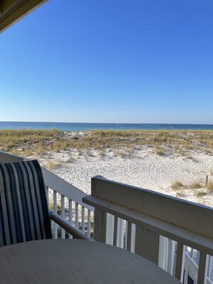
Anyway, here’s a pic from just behind the dunes.

- Joined
- Sep 17, 2008
- Messages
- 9,434
I’m in Destin now sitting on my patio watching the very calm gulf, thank goodness. The weather is perfect—I’ve already had my walk on the beach this morning and will go back to claim my chairs and umbrella soon. I feel terrible for all those who lost their lives in Ian, some really awful stories of drownings and scary rescues on YouTube as I was following the toll this week. Part if me feels some guilt for enjoying myself here but I also really needed this time alone in this particular place to regroup and do some reflection and self-evaluation. That’s hard to do at home with all the life stuff constantly going on.
Anyway, here’s a pic from just behind the dunes.
Beautiful! You should enjoy this absolutely (I know I would!)
Share:
The Ultimate Guide to Men’s Wedding Bands: Metals, Fit & Finish
The Ultimate Guide to Men’s Wedding Bands: Metals, Fit & Finish - 06/27
Chipped Diamonds: Causes, Risks, and What You Should Do About It
Chipped Diamonds: Causes, Risks, and What You Should Do About It - 06/27


300x240.png)