You are using an out of date browser. It may not display this or other websites correctly.
You should upgrade or use an alternative browser.
You should upgrade or use an alternative browser.
Hurricane season: We got some stuff to watch (FL, Gulf, Eastern US)
- Thread starter Arcadian
- Start date
- Joined
- Sep 17, 2008
- Messages
- 9,390
It is and not likely to drop. it will probably get stronger but they may not know until they go back and look at the historical data.Thanks for updating the thread @Arcadian - this thing is huge. Hopefully it doesn't get any stronger. Basically a category 5 now, but hopefully it drops down again.
Waiting for the 1100 to see what they're finding.
- Joined
- Dec 17, 2008
- Messages
- 27,830
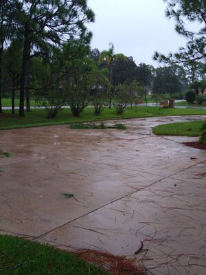
We're dealing with light to medium rain, and some mild winds with a few gusts every now and then. Not thrilled to hear about all
the tornados @Arcadian ... that's pretty scary. Sorry you are having to deal with physical issues due to the storm. Definitely makes
it a whole lot harder than it should be. DH is dragging in plants as we speak. I think he thought he had more time before the rain
started but...oh well, he's getting wet.
Stay safe everyone. I'm hoping it dies down a lot by the time it hits your area @RetroQT . I hope our Tampa Bay/Ft. Myers PSers
have left the area or are buckled down for the remainder.
@elizat Stay safe and keep us posted.
- Joined
- Sep 17, 2008
- Messages
- 9,390
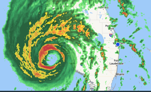
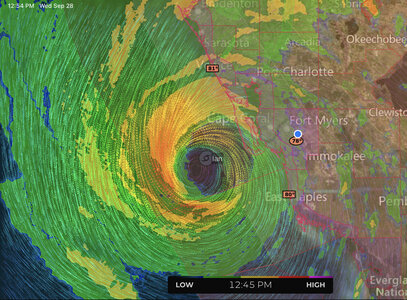
No changes and that makes some sense. Storm is starting to crawl ashore and the TS force gusts are getting more consistent on the east side where I am. the wind field is huge and covers both sides right now. We are oddly getting some sunlight in between these very fast moving dark cloud bands.
Carolinas and Georgia need to be really watching this thing close.
@tyty333 I think up in Brevard they changed to hurricane warning.

000
WTNT44 KNHC 281458
TCDAT4
Hurricane Ian Discussion Number 24
NWS National Hurricane Center Miami FL AL092022
1100 AM EDT Wed Sep 28 2022
Air Force Reserve and NOAA Hurricane Hunter data was absolutely
critical this morning in diagnosing the rapid intensification of
Ian, despite both planes undergoing multiple eyewall penetrations
experiencing severe turbulence. That data supported an intensity of
about 135 kt a few hours ago. Since that time, high-resolution
Tampa Doppler radar data has been sampling the eyewall near 10,000
ft with winds up to 155 kt, indicating that Ian is on the threshold
of category 5 status. The maximum winds are set to 135 kt on this
advisory.
Ian is expected to make landfall in southwestern Florida in the next
few hours as a catastrophic hurricane. No changes were made to the
track forecast near Florida, except to be faster to come into line
with the latest consensus aids. One important change is that Ian
is likely to remain more intact as it crosses the Florida peninsula
(due to both its stronger initial wind speed and its faster forecast
forward speed), and this now increases the threat of hurricane-force
winds on the east coast of Florida. This necessitates the issuance
of a Hurricane Warning on the east coast of central Florida. While
significant re-strengthening of Ian might not occur over the
Atlantic Ocean, model guidance has been catching up with a
trough interaction from a shortwave over the southern United
States, and are stronger than yesterday on Ian's intensity with
more baroclinic forcing. Thus, a Hurricane Watch has been issued
from northeastern Florida northward up the coast through most of
coastal South Carolina. The new intensity forecast is raised from
the previous one, near the latest statistical-dynamical guidance.
Key Messages:
1. Catastrophic storm surge inundation of 12 to 18 feet above ground
level along with destructive waves are expected somewhere along the
southwest Florida coastline from Englewood to Bonita Beach,
including Charlotte Harbor. Residents in these areas should urgently
follow any evacuation orders in effect.
2. Catastrophic wind damage is beginning along the southwestern
coast of Florida today near the landfall location. Hurricane-force
winds are expected to extend well inland along near the core of Ian.
Preparations to protect life and property should be urgently rushed
to completion.
3. Heavy rainfall will spread across the Florida peninsula through
Thursday and reach portions of the Southeast U.S. later this week
and this weekend. Widespread, life-threatening catastrophic
flooding is expected across portions of central Florida with
considerable flooding in southern Florida, northern Florida,
southeastern Georgia and coastal South Carolina. Widespread,
prolonged major and record river flooding is expected across
central Florida.
4. Hurricane conditions are expected along the east-central Florida
coast overnight, where a Hurricane Warning has been issued.
Hurricane conditions are possible from northeastern Florida to
portions of South Carolina on Thursday and Friday, and a Hurricane
Watch has been issued for that area.
FORECAST POSITIONS AND MAX WINDS
INIT 28/1500Z 26.3N 82.5W 135 KT 155 MPH
12H 29/0000Z 27.3N 82.1W 105 KT 120 MPH...INLAND
24H 29/1200Z 28.3N 81.4W 60 KT 70 MPH...INLAND
36H 30/0000Z 29.3N 80.8W 55 KT 65 MPH...OVER WATER
48H 30/1200Z 30.8N 80.6W 55 KT 65 MPH...OVER WATER
60H 01/0000Z 32.9N 80.9W 45 KT 50 MPH...INLAND
72H 01/1200Z 34.7N 81.5W 30 KT 35 MPH...POST-TROP/EXTRATROP
96H 02/1200Z 36.0N 81.5W 20 KT 25 MPH...POST-TROP/EXTRATROP
120H 03/1200Z...DISSIPATED
$$
Forecaster Blake
Carolinas and Georgia need to be really watching this thing close.
@tyty333 I think up in Brevard they changed to hurricane warning.

000
WTNT44 KNHC 281458
TCDAT4
Hurricane Ian Discussion Number 24
NWS National Hurricane Center Miami FL AL092022
1100 AM EDT Wed Sep 28 2022
Air Force Reserve and NOAA Hurricane Hunter data was absolutely
critical this morning in diagnosing the rapid intensification of
Ian, despite both planes undergoing multiple eyewall penetrations
experiencing severe turbulence. That data supported an intensity of
about 135 kt a few hours ago. Since that time, high-resolution
Tampa Doppler radar data has been sampling the eyewall near 10,000
ft with winds up to 155 kt, indicating that Ian is on the threshold
of category 5 status. The maximum winds are set to 135 kt on this
advisory.
Ian is expected to make landfall in southwestern Florida in the next
few hours as a catastrophic hurricane. No changes were made to the
track forecast near Florida, except to be faster to come into line
with the latest consensus aids. One important change is that Ian
is likely to remain more intact as it crosses the Florida peninsula
(due to both its stronger initial wind speed and its faster forecast
forward speed), and this now increases the threat of hurricane-force
winds on the east coast of Florida. This necessitates the issuance
of a Hurricane Warning on the east coast of central Florida. While
significant re-strengthening of Ian might not occur over the
Atlantic Ocean, model guidance has been catching up with a
trough interaction from a shortwave over the southern United
States, and are stronger than yesterday on Ian's intensity with
more baroclinic forcing. Thus, a Hurricane Watch has been issued
from northeastern Florida northward up the coast through most of
coastal South Carolina. The new intensity forecast is raised from
the previous one, near the latest statistical-dynamical guidance.
Key Messages:
1. Catastrophic storm surge inundation of 12 to 18 feet above ground
level along with destructive waves are expected somewhere along the
southwest Florida coastline from Englewood to Bonita Beach,
including Charlotte Harbor. Residents in these areas should urgently
follow any evacuation orders in effect.
2. Catastrophic wind damage is beginning along the southwestern
coast of Florida today near the landfall location. Hurricane-force
winds are expected to extend well inland along near the core of Ian.
Preparations to protect life and property should be urgently rushed
to completion.
3. Heavy rainfall will spread across the Florida peninsula through
Thursday and reach portions of the Southeast U.S. later this week
and this weekend. Widespread, life-threatening catastrophic
flooding is expected across portions of central Florida with
considerable flooding in southern Florida, northern Florida,
southeastern Georgia and coastal South Carolina. Widespread,
prolonged major and record river flooding is expected across
central Florida.
4. Hurricane conditions are expected along the east-central Florida
coast overnight, where a Hurricane Warning has been issued.
Hurricane conditions are possible from northeastern Florida to
portions of South Carolina on Thursday and Friday, and a Hurricane
Watch has been issued for that area.
FORECAST POSITIONS AND MAX WINDS
INIT 28/1500Z 26.3N 82.5W 135 KT 155 MPH
12H 29/0000Z 27.3N 82.1W 105 KT 120 MPH...INLAND
24H 29/1200Z 28.3N 81.4W 60 KT 70 MPH...INLAND
36H 30/0000Z 29.3N 80.8W 55 KT 65 MPH...OVER WATER
48H 30/1200Z 30.8N 80.6W 55 KT 65 MPH...OVER WATER
60H 01/0000Z 32.9N 80.9W 45 KT 50 MPH...INLAND
72H 01/1200Z 34.7N 81.5W 30 KT 35 MPH...POST-TROP/EXTRATROP
96H 02/1200Z 36.0N 81.5W 20 KT 25 MPH...POST-TROP/EXTRATROP
120H 03/1200Z...DISSIPATED
$$
Forecaster Blake
- Joined
- Sep 17, 2008
- Messages
- 9,390
- Joined
- Sep 17, 2008
- Messages
- 9,390
- Joined
- Sep 17, 2008
- Messages
- 9,390
winds are picking up here from the southwest.
000
WTNT64 KNHC 281557
TCUAT4
Hurricane Ian Tropical Cyclone Update
NWS National Hurricane Center Miami FL AL092022
1200 PM EDT Wed Sep 28 2022
...12 PM EDT IAN POSITION UPDATE...
...EYEWALL OF IAN MOVING ONSHORE AT SANIBEL AND CAPTIVA ISLANDS...
The Government of Cuba has discontinued all Tropical Storm Warnings
for Cuba.
A Weatherflow station near Sanibel Island, Florida recently
reported sustained winds of 71 mph (114 km/h) and a wind gust of
98 mph (158 km/h), and a River, Estuary, and Coastal Network
station at Redfish Pass recently reported sustained winds of 67 mph
(108 km/h) and a wind gust of 84 mph (135 km/h).
SUMMARY OF 1200 PM EDT...1600 UTC...INFORMATION
----------------------------------------------
LOCATION...26.4N 82.5W
ABOUT 45 MI...70 KM SW OF PUNTA GORDA FLORIDA
ABOUT 50 MI...80 KM WNW OF NAPLES FLORIDA
MAXIMUM SUSTAINED WINDS...155 MPH...250 KM/H
PRESENT MOVEMENT...NNE OR 15 DEGREES AT 9 MPH...15 KM/H
MINIMUM CENTRAL PRESSURE...937 MB...27.67 INCHES
$$
Forecaster Beven
- Joined
- Dec 17, 2008
- Messages
- 27,830
- Joined
- Mar 2, 2013
- Messages
- 6,321
- Joined
- Mar 26, 2006
- Messages
- 15,341
Our flight out of Orlando scheduled for tomorrow was cancelled yesterday so we headed out in the rental car at 5:30 this morning. We’re currently stopped at a Bojangles for lunch north of Atlanta. Then back on the road toward O’Hare where my car is parked. It’s an adventure! And look what I just bought at the gas station! Looking on the bright side, if this hadn’t happened I never would have found a beverage this… uh… amazing!


- Joined
- Sep 17, 2008
- Messages
- 9,390
- Joined
- Sep 17, 2008
- Messages
- 9,390
- Joined
- Sep 17, 2008
- Messages
- 9,390
Napped and a bit refreshed but unfortunately still feeling all that pressure. its less now because the pressure is rising but still feels bad. would not wish this on anyone.
I'm looking at some of the numbers online and the damage and its absolutely heart breaking. There are people that left south Florida to central to avoid hurricanes but here we are! Not a place to avoid such a thing.
I'm now seeing birds out though we do have winds and some wind gusts, its not too terrible right now. Its supposed to get a little bad overnight as the thing pulls to the middle of the state though. Still, I expect we'll get some additional rains but nothing like what the west side is getting and definitely nothing like what the northeast quadrant of the storm will get.
Anyone that needs to know disaster info can go here: https://www.floridadisaster.org/info/
Also, lot of power outages as expected where the eye came onshore.

 poweroutage.us
I'm looking at some of the numbers online and the damage and its absolutely heart breaking. There are people that left south Florida to central to avoid hurricanes but here we are! Not a place to avoid such a thing.
I'm now seeing birds out though we do have winds and some wind gusts, its not too terrible right now. Its supposed to get a little bad overnight as the thing pulls to the middle of the state though. Still, I expect we'll get some additional rains but nothing like what the west side is getting and definitely nothing like what the northeast quadrant of the storm will get.
Anyone that needs to know disaster info can go here: https://www.floridadisaster.org/info/
Also, lot of power outages as expected where the eye came onshore.

Florida Power Outages Map, Jan 2025
- Joined
- Feb 12, 2011
- Messages
- 4,795
- Joined
- Jun 26, 2007
- Messages
- 8,799
- Joined
- Apr 19, 2004
- Messages
- 26,626
- Joined
- Sep 17, 2008
- Messages
- 9,390
For southeast FL its mostly over though we do have winds to contend with and some rain. Nothing like the west side of the state and hopefully a weaker storm will be helpful for the northern part of the state.
Its moving at a very slow rate of speed though which from what I could see, the storms are heavily weighted in the north northeast quadrant. its going to spin water back into Tampa Bay at some point. I saw that the wind pushed the water out...which is spooky.
Anyway the windfield as you can see is much bigger than the peninsula so hurricane warnings are on both sides for that reason (plus still over 100mph winds!)
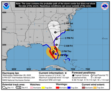
Pressure is coming up as its over land now (my head is still hurting a lot but its manageable compared to what it was like earlier)
Northern FL/Central FL folks, be careful tonight. I will be thinking of you all up there.
Its moving at a very slow rate of speed though which from what I could see, the storms are heavily weighted in the north northeast quadrant. its going to spin water back into Tampa Bay at some point. I saw that the wind pushed the water out...which is spooky.
Anyway the windfield as you can see is much bigger than the peninsula so hurricane warnings are on both sides for that reason (plus still over 100mph winds!)

Pressure is coming up as its over land now (my head is still hurting a lot but its manageable compared to what it was like earlier)
Northern FL/Central FL folks, be careful tonight. I will be thinking of you all up there.
000
WTNT44 KNHC 282058
TCDAT4
Hurricane Ian Discussion Number 25
NWS National Hurricane Center Miami FL AL092022
500 PM EDT Wed Sep 28 2022
An Air Force Reserve Hurricane Hunter aircraft provided the last
fix on Ian just before the hurricane made landfall at Cayo Costa,
Florida, with the landfall time near at 305 pm EDT. The
minimum pressure had risen to about 940 mb at landfall, suggesting
that the winds had come down slightly, and the landfall intensity
was estimated near 130 kt. While there hasn't been much in situ
data recently, satellite images show that the eye has become more
cloud filled, and Tampa Doppler radar data is indicating a gradual
reduction in winds. The initial intensity is set to 120 kt on this
advisory.
Further weakening is forecast while Ian moves over central Florida
during the next day and emerges into the western Atlantic later on
Thursday. While there is a lot of vertical wind shear in the
environment there, a favorable trough interaction from a trough in
the southern United States is expected to counteract the shear,
resulting in Ian staying a strong tropical storm through landfall
on the southeast U.S. coast. Little change was made to the
intensity forecast, which is near or somewhat above the consensus
guidance.
The hurricane is moving to the north-northeast at about 8 kt. The
aforementioned trough is likely to cause Ian to turn northward over
the western Atlantic and to the north-northwest by the weekend.
Model guidance is just a bit faster to the north-northeast than the
last cycle, and the new forecast is nudged in that direction. The
trough will probably cause Ian to transition to an extratropical
cyclone in a few days over the southeastern United States, and this
new forecast reflects this likelihood.
Key Messages:
1. Catastrophic storm surge inundation of 12 to 18 feet above ground
level along with destructive waves is ongoing along the southwest
Florida coastline from Englewood to Bonita Beach, including
Charlotte Harbor.
2. Catastrophic wind damage is occurring along the southwestern
coast of Florida in areas near the eyewall of Ian. Hurricane-force
winds, especially in gusts, are expected to spread inland to central
Florida near the core of Ian through early Thursday. Hurricane
conditions are expected along the east-central Florida coast
overnight through early Thursday.
3. Heavy rainfall will spread across the Florida peninsula through
Thursday and reach portions of the Southeast U.S. later this week
and this weekend. Widespread, life-threatening catastrophic
flooding, with major to record river flooding, are expected to
continue across portions of central Florida with considerable
flooding in northern Florida, southeastern Georgia and eastern South
Carolina.
4. There is a danger of life-threatening storm surge on Thursday
and Friday along the coasts of northeast Florida, Georgia, and South
Carolina, with hurricane conditions possible. Residents in these
areas should follow any advice given by local officials.
FORECAST POSITIONS AND MAX WINDS
INIT 28/2100Z 26.9N 82.0W 120 KT 140 MPH...INLAND
12H 29/0600Z 27.8N 81.6W 75 KT 85 MPH...INLAND
24H 29/1800Z 28.8N 81.0W 55 KT 65 MPH...INLAND
36H 30/0600Z 30.0N 80.6W 55 KT 65 MPH...OVER WATER
48H 30/1800Z 31.9N 80.6W 55 KT 65 MPH...OVER WATER
60H 01/0600Z 34.0N 81.0W 40 KT 45 MPH...INLAND
72H 01/1800Z 36.0N 81.5W 20 KT 25 MPH...POST-TROP/EXTRATROP
96H 02/1800Z...DISSIPATED
$$
Forecaster Blake
- Joined
- Jun 7, 2014
- Messages
- 9,595
@Arcadian , Thank you for keeping everyone here updated. I hope all the Florida PSers are safe and dry. Please stay safe everyone.
RetroQT
Brilliant_Rock
- Joined
- Oct 14, 2018
- Messages
- 732
- Joined
- Sep 17, 2008
- Messages
- 9,390
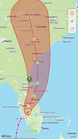
The current track from NHC (and check out that windfield! We had crazy wind all last night, some power outages for my area. In the discussion they talk about Ian moving off the coast, but that means the eye, the windfield will still cover much of the peninsula. Speaking of, this morning when I took the pups out for a walk, the clouds were giant and moving in a circular pattern. Pretty but kinda scary because you knew what they were.
Georgia and SC should be preparing for tropical storm at this point.
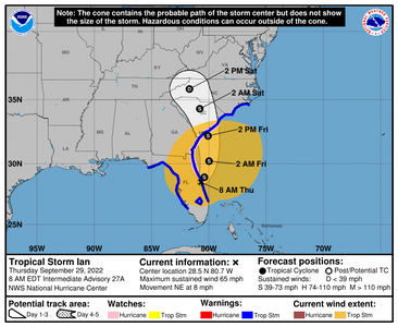
Georgia and SC should be preparing for tropical storm at this point.

000
WTNT44 KNHC 290859
TCDAT4
Tropical Storm Ian Discussion Number 27
NWS National Hurricane Center Miami FL AL092022
500 AM EDT Thu Sep 29 2022
Ian's center continues to move northeastward across central Florida,
and nearly all of the heavy rains are located to the north over
northeastern Florida. NWS WSR-88D Doppler velocities from the
Melbourne and Tampa radars have decreased significantly since last
evening, and based on that data, Ian is now a tropical storm with
maximum sustained winds of 55 kt. This intensity is also supported
by wind observations across Florida, with the highest recent
sustained wind being 52 kt at New Smyrna Beach.
Ian's current motion is northeastward, or 040/7 kt. The tail end
of a deep-layer trough is expected to detach from the main trough
axis over the southeastern United States during the next 24 to 48
hours, and Ian is forecast to move around the eastern periphery of
this feature, turning north-northeastward later today and then
north-northwestward by Friday night. In this scenario, Ian should
move off the east coast of Florida later today, and then swing
northward toward the South Carolina coast during the next 36 hours
or so. Although there is some cross-track spread in the guidance,
they all agree on this general scenario, and the NHC track forecast
lies where most of the models are packed. No significant changes
were made to the previous prediction.
Little change in intensity is forecast during the next 24 hours or
so, mainly due to strong southwesterly shear. After 24 hours,
global models are suggesting that Ian could have some favorable
interaction with the eastern U.S. trough, all while it's moving
over the warm 28-29 degree Celsius waters of the Gulf Stream. As a
result, some slight strengthening is indicated in the official
forecast by 36 hours, and Ian could be near hurricane intensity as
it's approaching the coast of South Carolina. This possibility is
accounted for by the Hurricane Watch that is effect for the area.
After moving inland, Ian is expected to weaken quickly, and global
models indicate it should dissipate or become absorbed by another
broader area of low pressure over the Carolinas by day 3.
Key Messages:
1. Coastal water levels continue to subside along the west coast of
Florida. There is a danger of life-threatening storm surge today
through Friday along the coasts of northeast Florida, Georgia,
and South Carolina. Residents in these areas should follow any
advice given by local officials.
2. Tropical-storm-force winds are expected to spread northward
across northeastern Florida, Georgia, and the Carolina coasts
through Friday. Hurricane conditions are possible through
Friday along the coasts of northeastern Florida, Georgia and South
Carolina where a Hurricane Watch in effect.
3. Widespread, life-threatening catastrophic flooding, with major to
record river flooding, will continue today across portions of
central Florida with considerable flooding in northern Florida,
southeastern Georgia and eastern South Carolina expected today
through the end of the week.
FORECAST POSITIONS AND MAX WINDS
INIT 29/0900Z 28.0N 80.9W 55 KT 65 MPH...INLAND
12H 29/1800Z 28.9N 80.4W 55 KT 65 MPH...OVER WATER
24H 30/0600Z 30.2N 80.0W 55 KT 65 MPH...OVER WATER
36H 30/1800Z 32.2N 80.1W 60 KT 70 MPH...OVER WATER
48H 01/0600Z 34.3N 80.8W 35 KT 40 MPH...INLAND
60H 01/1800Z 35.8N 81.7W 25 KT 30 MPH...INLAND
72H 02/0600Z...DISSIPATED
$$
Forecaster Berg
RetroQT
Brilliant_Rock
- Joined
- Oct 14, 2018
- Messages
- 732
- Joined
- Dec 17, 2008
- Messages
- 27,830
- Joined
- Sep 17, 2008
- Messages
- 9,390
Ian is expected to restrengthen to a hurricane. Georgia, North and South Carolina needs to pay close attention. Again whats in orange is the windfield of this storm and its not really going to get that much smaller.
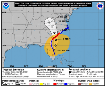

000
WTNT44 KNHC 291500
TCDAT4
Tropical Storm Ian Discussion Number 28
NWS National Hurricane Center Miami FL AL092022
1100 AM EDT Thu Sep 29 2022
The center of Ian has emerged into the western Atlantic Ocean to
the north of Cape Canaveral. While satellite images show the
system is becoming a hybrid cyclone, with frontal features outside
of the core of Ian, the winds from multiple sources are notable.
Velocity data from NWS Doppler radar indicate maximum winds of about
70-75 kt at 10,000 ft over land, and sustained winds of about 55 kt
were recorded in the Daytona Beach area earlier this morning. These
data support a higher initial intensity, now 60 kt for this
advisory.
The storm is moving northeastward at about 8 kt. Ian has stubbornly
gone east of the track forecast for the past couple of days and has
moved back over water faster than expected. A mid-level shortwave
trough moving southward across the southern United States should
turn Ian northward overnight and north-northwestward on Saturday.
The official track forecast is shifted to the east, consistent with
the latest consensus guidance.
Ian should move over the Gulf Stream tonight and tomorrow for a
longer period of time than previously anticipated, which should
maintain Ian's central convection. Additionally, an increased
pressure gradient on the northwestern side from a stationary front
near the southeastern US, should provide a boost to the wind speeds
on that side of the storm. We now expect Ian to become a hurricane
again by this evening. As the system approaches South Carolina, Ian
should maintain this intensity, and Hurricane Warnings have been
issued for the entire coast of South Carolina. This scenario is
consistent with the global and regional hurricane model guidance.
It is worth noting that Ian is forecast to have atypical structure
when it nears the southeastern United States, and strong winds will
extend well ahead of the center, even on the northwestern side.
Key Messages:
1. There is a danger of life-threatening storm surge through Friday
along the coasts of northeast Florida, Georgia, and South Carolina.
Residents in these areas should follow any advice given by local
officials.
2. Hurricane-force winds are expected across the South Carolina
coast beginning early Friday, where a Hurricane Warning has been
issued. Hurricane conditions are possible by tonight along the
coasts of northeastern Florida and Georgia, where a Hurricane Watch
is in effect. Preparations should be rushed to completion since
tropical-storm-force winds will begin well before the center
approaches the coast.
3. Ongoing major-to-record river flooding will continue across
portions of central Florida, with considerable flooding in northern
Florida. Considerable flash and urban flooding is expected across
coastal portions of northeast Florida through Friday. Local
significant flooding in southeastern Georgia and eastern South
Carolina is expected through the end of the week.
FORECAST POSITIONS AND MAX WINDS
INIT 29/1500Z 28.7N 80.4W 60 KT 70 MPH
12H 30/0000Z 30.0N 79.9W 65 KT 75 MPH
24H 30/1200Z 31.8N 79.8W 65 KT 75 MPH
36H 01/0000Z 34.0N 80.3W 45 KT 50 MPH...INLAND
48H 01/1200Z 35.9N 81.1W 30 KT 35 MPH...POST-TROP/EXTRATROP
60H 02/0000Z 37.0N 82.0W 15 KT 15 MPH...POST-TROP/EXTRATROP
72H 02/1200Z...DISSIPATED
$$
Forecaster Blake
Last edited:
- Joined
- Feb 22, 2014
- Messages
- 4,387
- Joined
- Dec 17, 2008
- Messages
- 27,830
- Joined
- Sep 17, 2008
- Messages
- 9,390
Arcadian, you are awesome! You have done so much to inform and warn people here! Even though I’m in a different area of the country, I keep checking in to learn from you. To all our PS friends in Florida (or your loved ones) my heart goes out to you!
I try. Unlike earthquakes (and even some tornadoes or dust storms), there's usually time to prepare for these types of events, and certain storms have a particular look that makes them worth watching long term. I'm still learning a whole lot though and certainly unlike a newscaster, no one is going to poo poo me if I make a mistake. Still better safe than sorry is my motto.
But I cut my teeth on the midwest! cool breeze and the air got still, you may be dealing with a tornado before you know it. green skies? hail. And I learned to read the clouds (thanks to my grandparents!) Even winter storms had a particular smell to them (way different from a typical thunderstorm)
I'm just weird I guess...
- Joined
- Sep 17, 2008
- Messages
- 9,390
- Joined
- Sep 17, 2008
- Messages
- 9,390
Florida power outages. Theres a lot https://poweroutage.us/area/state/florida
Georgia is now starting to have power outages https://poweroutage.us/
Georgia is now starting to have power outages https://poweroutage.us/
- Joined
- Sep 17, 2008
- Messages
- 9,390
Ian is a hurricane again and its not entirely impossible this could end up being a cat 2.
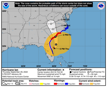

000
WTNT44 KNHC 292059
TCDAT4
Hurricane Ian Discussion Number 29
NWS National Hurricane Center Miami FL AL092022
500 PM EDT Thu Sep 29 2022
Ian remains a hybrid tropical cyclone with characteristics of an
extratropical low, including a comma-pattern on satellite images
and some frontal features in the outer circulation. The cyclone
continues to have a warm core, however, and all indications are that
it will re-develop strong convection over the center overnight.
Based on Melbourne Doppler radar velocity data of persistent 70-80-
kt winds from 5-10 thousand feet, and earlier sustained winds of
about 60 kt near that band from an observation in New Smyrna Beach,
the initial wind speed is raised to 65 kt. This makes Ian a
hurricane again. An Air Force Reserve Hurricane Hunter aircraft
is scheduled to fly through Ian this evening and will provide a
better intensity estimate.
Ian finally appears to be making more of a turn to the north-
northeast this afternoon. The hurricane should turn to the north
overnight due to the incoming trough diving southward over the
southern United States and then north-northwestward on Saturday
with an increase in forward speed. While the overall synoptic
pattern is similar in all of the models, Ian has been uncooperative
and remains right of the previous track. Thus, the new forecast is
adjusted to the east, and lies east of the model consensus.
Assuming Ian re-develops thunderstorms near the core overnight, it
should take the expected north-northwest turn, but this shouldn't
be considered a confident forecast yet. Because of the
uncertainty, the Hurricane Warning has been extended eastward into
North Carolina to Cape Fear.
The hurricane is moving over the Gulf Stream for the next day or
so, where it has some time for further re-intensification.
Additionally, the trough interaction should provide a baroclinic
energy kick. These factors point to some strengthening before
landfall tomorrow. The new forecast is close to the GFS and
regional hurricane models and is a bit stronger than before. It
should be emphasized that while we don't expect Ian to be a classic
hurricane at landfall, this does not diminish the danger it poses.
Strong winds and storm surge will also extend far from the center
and will begin well before the center arrives.
Key Messages:
1. There is a danger of life-threatening storm surge through Friday
along the coasts of northeast Florida, Georgia, and South Carolina.
Residents in these areas should follow any advice given by local
officials.
2. Hurricane-force winds are expected across coasts of South
Carolina and southeastern North Carolina beginning early Friday,
where a Hurricane Warning is in effect. Hurricane conditions are
possible by tonight along the coasts of northeastern Florida,
Georgia, and North Carolina where a Hurricane Watch is in
effect. Preparations should be rushed to completion since
tropical-storm-force winds will begin well before the center
approaches the coast.
3. Ongoing major-to-record river flooding will continue across
portions of central Florida, with considerable flooding in northern
Florida. Considerable flash and urban flooding is expected across
coastal portions of northeast Florida through Friday. Local
significant flooding in southeastern Georgia and eastern South
Carolina is expected through the end of the week.
FORECAST POSITIONS AND MAX WINDS
INIT 29/2100Z 29.3N 79.9W 65 KT 75 MPH
12H 30/0600Z 30.5N 79.4W 70 KT 80 MPH
24H 30/1800Z 32.8N 79.6W 70 KT 80 MPH
36H 01/0600Z 35.0N 80.4W 30 KT 35 MPH...POST-TROP/EXTRATROP
48H 01/1800Z 36.5N 81.0W 15 KT 15 MPH...POST-TROP/EXTRATROP
60H 02/0600Z...DISSIPATED
$$
Forecaster Blake
Engagement Ring Trends 2025: Styles Set to Shine
Engagement Ring Trends 2025: Styles Set to Shine - 01/15
Engagement Rings Under $2500: Affordable Elegance for Every Budget
Engagement Rings Under $2500: Affordable Elegance for Every Budget - 01/13



300x240.png)