shape
carat
color
clarity

Hurricane season: We got some stuff to watch (FL, Gulf, Eastern US)

Thank you everyone for the well wishes...this turn to the east is not good for us but we'll be fine. Unfortunately, this storm looks like
its determined to affect the whole peninsula of FL.

Due to the east turn, my parents decided to run north and then west across the panhandle. I'm not thrilled about that. I'd rather
have them closer to me but they are adults with good sense so I'll deal with it. We're supposed to hear from the school system later
today to find out what's going on with school. I think they will probably cancel school for tomorrow or Thursday.

Its somewhat gray, overcast, and ominous looking where I'm at.

I'm hoping everyone on the West coast has a plan and is heading on their way out of the area. You guys are in my thoughts.

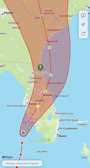
We are in Saint Augustine, about 15 miles inland. So we are planning to stay put. As of now, the expectation is a tropical storm at best in our area. But definitely thinking about all of y’all that are on the West Coast!
 
We are in Saint Augustine, about 15 miles inland. So we are planning to stay put. As of now, the expectation is a tropical storm at best in our area. But definitely thinking about all of y’all that are on the West Coast!

I went to Flagler for undergrad! St. Augustine is very pretty. When I attended, there was still no AC in the women's dorms.

We are in Tampa Bay and are staying put. All outside prep is done. Just need to do some food prep today. I'll continue working remotely until we lose connection. We have done what we can.

We are the very north end of it, one exit from Jax. But yes, Flagler and that historic area is awesome!

My in-laws are in Dunedin and staying out as well. I hope all y’all will be safe with little to no damage. I think power outage is pretty much going to be a given. It’ll just depend on how long. The longest we had an outage was just over a week.
 
Track has changed yet again. Its moving east. there's some talk it could come in at Venice or Fort Meyers.

I will put additional stuff in another post.
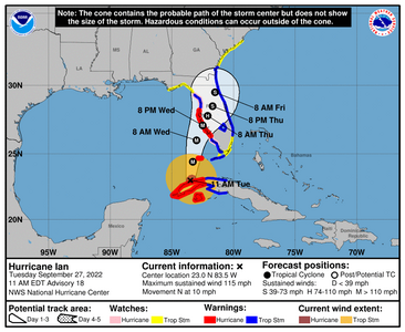
1100939_3day_cone_no_line_and_wind.png

000
WTNT44 KNHC 271500
TCDAT4

Hurricane Ian Discussion Number 18
NWS National Hurricane Center Miami FL AL092022
1100 AM EDT Tue Sep 27 2022

The well-defined eye of Ian emerged off the coast of western Cuba
about an hour ago. Earlier reports from the NOAA Hurricane Hunter
aircraft indicate that Ian strengthened up through landfall, with an
estimated pressure of 947 mb over western Cuba. While the hurricane
has filled somewhat due to the passage over Cuba, Air Force Reserve
and NOAA Hurricane Hunter data show that it has grown in size. The
initial wind speed is set to 100 kt.

Ian is moving northward, or 005/9 kt. Dropsonde data from the NOAA
G-IV aircraft indicate a potent upper-level trough is over the
western Gulf of Mexico. The strength of this trough, the associated
southwesterly flow, and the vertical depth of Ian appear to be the
keys to the forecast. There has been a notable trend toward the
hurricane remaining more intact up through landfall, meaning Ian is
likely to turn to the northeast and not move as slowly as previously
anticipated. However, it should be emphasized that this track
remains very uncertain, with a typical spread in the steering
features leading to big speed and track differences down the line,
not to mention the oblique angle of approach to Florida. The latest
forecast is adjusted to the southeast for this advisory, showing
landfall 6-12 hours faster than before, and we will have to see if
the southern trend continues in the afternoon guidance. The rest of
the forecast after landfall has been adjusted to the northeast as
well, though it is still slower than the consensus guidance at
longer range.

The hurricane should remain in a favorable environment for
restrengthening over the next day or so while it moves over the warm
waters of the southeastern Gulf of Mexico and in light-shear
conditions. While the shear should increase by tomorrow, it isn't
expected to be enough to significantly weaken the hurricane before
landfall. Model guidance is in fairly good agreement on this
scenario, and the NHC intensity forecast continues to call for an
extremely dangerous hurricane landfall for southwestern Florida.


The new forecast necessitates a Hurricane Watch for portions of
extreme southwestern Florida, and a Tropical Storm Watch for the
rest of southeastern Florida that wasn't previously under a watch.
Users are reminded to not focus on the exact track as some
additional adjustments to the track are possible. Significant wind,
storm surge, and rainfall hazards will extend far from the center.


Key Messages:

1. Life-threatening storm surge, hurricane-force winds, flash floods
and possible mudslides are expected to continue in portions of
western Cuba today. Devastating wind damage is expected near the
core of Ian.

2. Life-threatening storm surge looks increasingly likely along much
of the Florida west coast where a storm surge warning is in effect,
with the highest risk from Fort Myers to the Tampa Bay region.
Residents in these areas should listen to advice given by local
officials and follow evacuation orders if made for your area.


3. Hurricane-force winds are expected in the hurricane warning area
in southwest and west-central Florida beginning Wednesday morning
with tropical storm conditions expected by this evening. Residents
should rush all preparations to completion today.

4. Heavy rainfall will increase across the Florida Keys and south
Florida today, spreading into central and northern Florida tonight
and Wednesday, into the Southeast U.S. by Thursday and Friday,
likely causing flash, urban, and small stream flooding. Considerable
flooding is expected across central Florida into southern Georgia
and coastal South Carolina, with widespread, prolonged moderate to
major river flooding expected across central Florida.


FORECAST POSITIONS AND MAX WINDS

INIT 27/1500Z 23.0N 83.5W 100 KT 115 MPH
12H 28/0000Z 24.4N 83.3W 115 KT 130 MPH
24H 28/1200Z 26.0N 83.0W 115 KT 130 MPH
36H 29/0000Z 27.1N 82.5W 110 KT 125 MPH
48H 29/1200Z 27.8N 82.1W 75 KT 85 MPH...INLAND
60H 30/0000Z 28.5N 81.7W 60 KT 70 MPH...INLAND
72H 30/1200Z 29.5N 81.5W 50 KT 60 MPH...INLAND
96H 01/1200Z 33.0N 81.8W 35 KT 40 MPH...INLAND
120H 02/1200Z 35.0N 81.5W 25 KT 30 MPH...POST-TROP/EXTRATROP

$$
Forecaster Blake
 
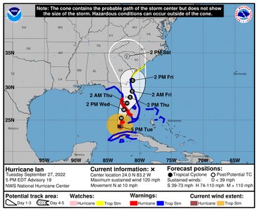
This storm has a big hurricane force wind field, with even bigger tropical storm force field. Keep in mind that the florida peninsula is about 165ish miles across and this storm is roughly 500 miles across. Thats bigger than even Irma was. So with that, effects will be felt on both coasts.

The cone is only the eye its not the entire storm though the worst tends to happen around the eye wall.

Its pretty much real time at this point. Those in the path, stay safe. please know your zone, and evacuate if you're too close to the action.

South Florida counties are currently under Tornado watch as we're getting the outer bands currently.


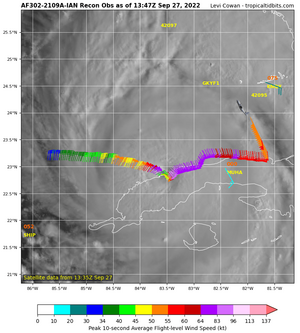
Recon data as the storm comes off Cuba

recon_AF302-2109A-IAN.png


Over the next few days I'll be posting real time data when I can.
 
Oof. Thanks for all the updates again, @Arcadian . Sucks that Ian is dragging things out and I am really sad to hear about the turtles. I hope you have enough supplies and such (and vape supplies) to get through this and that your headache goes away soon.

Here’s a retro Buffett song plus photo vid someone made:


Well, I'm not driving anywhere else today so... ;)2 seriously though thank you. its easing somewhat and I used the daytime vape, which is allowing the banging in my head to ease up. I'm obviously not high but I don't drive as a precaution (I could as its not illegal, but just as I don't drive when I have an active migraine if I can help it, I don't drive and vape either) However, I MAY have to go to CVS to get my meds later today if they're still open.

Yes the dunes are not that great up here. There was already serious beach erosion happening (and they dredged and put back sand last year) but its slipping again. Last week it was very evident.

This whole thing has been such a shitshow. If its at Ft Meyers thats right across the state from where I am. If its Venice, thats just slightly north but still in the vicinity.
 
Thank you everyone for the well wishes...this turn to the east is not good for us but we'll be fine. Unfortunately, this storm looks like
its determined to affect the whole peninsula of FL.

Due to the east turn, my parents decided to run north and then west across the panhandle. I'm not thrilled about that. I'd rather
have them closer to me but they are adults with good sense so I'll deal with it. We're supposed to hear from the school system later
today to find out what's going on with school. I think they will probably cancel school for tomorrow or Thursday.

Its somewhat gray, overcast, and ominous looking where I'm at.

I'm hoping everyone on the West coast has a plan and is heading on their way out of the area. You guys are in my thoughts.
Palm Beach County, Indian River County, and Martin County schools are closed tomorrow.

I think also the case for Broward and Miami Counties but have not seen any alerts (usually they would be considering the flood potentials.)
 
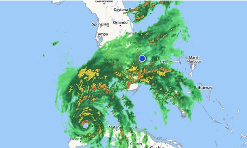
For some real perspective, this is the current radar
Current_radar.PNG
 
So our county closed schools for Wed and Thurs. I'm not surprised.

We're expecting Tropical Storm winds here also. Sustained in the 30s gusting into the 50s. That's really not much as far as
wind goes. A little worried about how much rain it's going to dump on our already saturated grounds though.
 
Our schools are out Wed-Fri with a Monday return. I think we are expecting about a foot of rain. Hopefully the estimates are higher than what we get.
 
 
161142I5dayconeno.png

952mb I believe.

000
WTNT44 KNHC 272059
TCDAT4

Hurricane Ian Discussion Number 19
NWS National Hurricane Center Miami FL AL092022
500 PM EDT Tue Sep 27 2022

The pressure on the last Air Force Hurricane Hunter aircraft fix
fell to about 952 mb, indicating that Ian is restrengthening
over the southeastern Gulf of Mexico. The eye of Ian remains
well-defined on visible imagery, although radar data from Key West
suggest that an eyewall replacement could be in the initial stages.

The initial wind speed is set to 105 kt, matching a blend of
earlier SFMR and flight-level wind data. The plane data also
showed that the area of hurricane-force winds is growing on the
east side of the cyclone.

Ian is moving east-of-due-north, or 010/9-kt, with occasional
wobbles to the north-northeast. A track toward the north-northeast
is expected for the next couple of days while it moves between a
ridge over the Bahamas and a trough over the western Gulf of Mexico.
There has been some model convergence this afternoon showing Ian
remaining stronger and vertically deeper through landfall. This
solution results in a faster track, again adjusted to the southeast,
and the new forecast is moved in that direction. This new NHC track
is close to the corrected model consensus and between the quicker
ECMWF and slower GFS models.
It should be emphasized that this
track remains uncertain, with a typical spread in the steering
features leading to big speed and track differences down the line,
not to mention the oblique angle of approach to Florida. In a few
days, more of the guidance is showing Ian interacting with a
shortwave trough over the southeastern United States, causing the
system to move back over the northwestern Atlantic in the longer
range, before turning northwestward back over land. The day 3-5
track forecast is also shifted eastward, although significant
re-strengthening is not expected at long range.


The outflow pattern of the hurricane is beginning to be impinged
upon in the southwestern quadrant, a sign that upper-level
southwesterly flow is starting to affect the outer circulation.
While the shear should increase up through landfall, it is just too
close-to-call whether it starts to weaken Ian or not, or whether the
larger system is able to resist the shear. Additionally, an eyewall
replacement cycle could be in its initial phases, although
predicting these structural changes is extremely difficult. The new
forecast is near the last one, a little higher than the consensus.
I should note that whether Ian comes ashore as category 4 hurricane
or a large category 3 after an eyewall cycle, avoiding a large and
destructive hurricane for Florida seems very unlikely, and residents
should heed the advice of local emergency management officials.


The new forecast necessitates a Hurricane Warning for portions of
extreme southwestern Florida, and a Tropical Storm Warning for the
rest of southeastern Florida that wasn't previously under a warning.
Users are reminded to not focus on the exact track as some
additional adjustments to the track are possible. Significant wind,
storm surge, and rainfall hazards will extend far from the center.


Key Messages:

1. Life-threatening storm surge is increasingly likely along the
Florida west coast where a storm surge warning is in effect, with
the highest risk from Naples to the Sarasota region. Residents in
these areas should listen to advice given by local officials and
follow any evacuation orders for your area.

2. Hurricane-force winds are expected in the hurricane warning area
in southwest and west-central Florida beginning Wednesday morning
with tropical storm conditions expected overnight. Devastating wind
damage is expected near the core of Ian. Residents should rush all
preparations to completion.

3. Heavy rainfall will affect most of the Florida Peninsula for the
next several days, spreading to the rest of the Southeast U.S. by
Thursday and Friday, likely causing flash, urban, and small stream
flooding. Considerable flooding is expected with widespread,
prolonged moderate to major river flooding expected across central
Florida.


FORECAST POSITIONS AND MAX WINDS

INIT 27/2100Z 24.0N 83.2W 105 KT 120 MPH
12H 28/0600Z 25.3N 82.9W 115 KT 130 MPH
24H 28/1800Z 26.6N 82.5W 115 KT 130 MPH
36H 29/0600Z 27.6N 82.0W 70 KT 80 MPH...INLAND
48H 29/1800Z 28.5N 81.5W 55 KT 65 MPH...INLAND
60H 30/0600Z 29.4N 81.2W 45 KT 50 MPH...INLAND
72H 30/1800Z 31.0N 81.1W 45 KT 50 MPH...OVER WATER
96H 01/1800Z 34.5N 82.0W 25 KT 30 MPH...POST-TROP/EXTRATROP
120H 02/1800Z...DISSIPATED

$$
Forecaster Blake
 
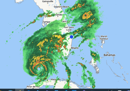
Current radar
1754currentradarfl.PNG
 
How is the weather down there @Arcadian ? Are you getting lots of rain or are you in
the clear right now?
 
Right now, light rain but you can hear thunder around me, mostly south and it comes up this way. We're still under tornado watch.

*edit*

They spotted funnel clouds in my area. Its gonna be a long night.
 
Last edited:
Sending good wishes to all in the path of the storm!
 
The storms are nuts right now. Lot of rain and tonado warnings. The bands are intense!

Eye is 90 miles of Naples.
 
Looks like it could make landfall as a Cat4. :cry2: Praying for Southwest Florida!

As for us in the NE corner of FL, it’s quiet for now. But we should have the rain starting later today and expect the storm’s impact to continue through Friday.
 
Last edited:
Looks like it’ll make landfall as a Cat4. :cry2: Praying for Southwest Florida!

We are praying for everyone in its path too. And sending bucketloads of safe vibes.
Please stay safe everyone.
 
Looking like a possible upgrade to Cat 5. This is a big one!! I’m sick to my stomach for my southern neighbors!!! This thing needs to weaken and fast, but it’s unlikely. Landfall expected late afternoon, I think.

Florida PSers: Please check in as y’all can.
 
The storm is currently 937mb and 155mph so a very high cat 4 I think eye landfall is still 2pm today? Still we're getting it bad down here. it was a very rough night to say the least.

I've gotten tons of tornado watches, I've seen some spinny clouds that didn't touch down this morning (good!) and we're getting tons of thunder and lightening. Not a fun storm at all. During a quiet point I got the pups outside for P&P neither are eager for walkies (also good!)

Based on the local news, there's storm damage down here. Tornadoes came through pretty much everywhere. Definitely rain damage.

Water came up to my front yard with some of the down pours and this is not a flood prone area! something to keep in mind.


000
WTNT44 KNHC 281057
TCDAT4

Hurricane Ian Special Discussion Number 23
NWS National Hurricane Center Miami FL AL092022
700 AM EDT Wed Sep 28 2022

This special advisory is being issued to update Ian's current and
forecast intensity. Recent NOAA and Air Force Reserve Hurricane
Hunter flight-level winds are as high as 160 kt, with SFMR data
around 135 kt, with a central pressure down to 937 mb. This
supports a current intensity of 135 kt
.

The forecast intensity is raised to 135 kt at landfall, and we are
now forecasting a catastrophic storm surge of 12 to 16 ft from
Englewood to Bonita Beach, Florida.
No other significant changes
were made to the forecast.

Previous discussion --

Ian completed an eyewall replacement cycle during the overnight
hours, and very recent data from an Air Force Reserve Hurricane
Hunter aircraft indicate that the hurricane has reached category 4
intensity. The plane reported that the central pressure has fallen
to 942 mb, down about 10 mb from around midnight. The plane
measured a peak 700-mb flight-level wind of 141 kt, and an SFMR
wind of 109 kt. A blend of the 700-mb reduced wind and the SFMR
yields an initial intensity of 120 kt. Although there is some
moderate shear over the hurricane, this is not likely to affect Ian
very much due to its large size. Some fluctuations in intensity are
possible before the center reaches the coast later today, but Ian is
expected to reach the coast as an extremely dangerous category 4
hurricane. Weakening is expected while Ian moves over the Florida
peninsula.

Ian has jogged a little to the left this morning, but the
longer-term motion remains north-northeastward or 015 degrees
at 9 kt. The hurricane should continue moving north-northeastward
through Thursday between the western side of a subtropical ridge
and a broad trough over the eastern United States. This motion is
expected to bring the center of Ian onshore along the west coast of
Florida later today, and over central Florida tonight and Thursday.
A shortwave trough that is forecast to move southward toward the
northwestern Gulf in about 24 to 36 hours is expected to sharpen
the trough over the eastern U.S. causing Ian to turn northward
along coast of northeastern Florida and Georgia Thursday night and
Friday. The model envelope did not change much this cycle, and very
little cross-track adjustments were needed to the official
forecast. The GFS and ECWMF are noticeably slower than the
remainder of the dynamical models, and the updated NHC track
forecast is a little slower than the previous advisory and slightly
slower than the TVCA consensus aid out of respect for those models.


Key Messages:

1. Catastrophic storm surge inundation of 12 to 16 feet above ground
level along with destructive waves are expected somewhere along the
southwest Florida coastline from Englewood to Bonita Beach,
including Charlotte Harbor. Residents in these areas should urgently
follow any evacuation orders in effect.

2. Catastrophic wind damage is expected along the southwestern
coast of Florida beginning in the next few hours where the core of
Ian makes landfall. Preparations to protect life and property
should be urgently rushed to completion.

3. Heavy rainfall will spread across the Florida peninsula through
Thursday and reach portions of the Southeast U.S. later this week
and this weekend. Widespread, life-threatening catastrophic
flooding is expected across portions of central Florida with
considerable flooding in southern Florida, northern Florida,
southeastern Georgia and coastal South Carolina. Widespread,
prolonged major and record river flooding expected across central
Florida.


FORECAST POSITIONS AND MAX WINDS

INIT 28/1100Z 25.9N 82.8W 135 KT 155 MPH
12H 28/1800Z 26.7N 82.4W 135 KT 155 MPH
24H 29/0600Z 27.7N 81.7W 80 KT 90 MPH...INLAND
36H 29/1800Z 28.7N 81.1W 50 KT 60 MPH...INLAND
48H 30/0600Z 29.8N 80.7W 45 KT 50 MPH...OVER WATER
60H 30/1800Z 31.6N 80.8W 45 KT 50 MPH
72H 01/0600Z 33.6N 81.4W 30 KT 35 MPH...INLAND
96H 02/0600Z 36.1N 82.1W 25 KT 30 MPH...POST-TROP/INLAND
120H 03/0600Z...DISSIPATED

$$
Forecaster Blake


000
WTNT44 KNHC 281057
TCDAT4

Hurricane Ian Special Discussion Number 23
NWS National Hurricane Center Miami FL AL092022
700 AM EDT Wed Sep 28 2022

This special advisory is being issued to update Ian's current and
forecast intensity. Recent NOAA and Air Force Reserve Hurricane
Hunter flight-level winds are as high as 160 kt, with SFMR data
around 135 kt, with a central pressure down to 937 mb. This
supports a current intensity of 135 kt.

The forecast intensity is raised to 135 kt at landfall, and we are
now forecasting a catastrophic storm surge of 12 to 16 ft from
Englewood to Bonita Beach, Florida. No other significant changes
were made to the forecast.

Previous discussion --

Ian completed an eyewall replacement cycle during the overnight
hours, and very recent data from an Air Force Reserve Hurricane
Hunter aircraft indicate that the hurricane has reached category 4
intensity. The plane reported that the central pressure has fallen
to 942 mb, down about 10 mb from around midnight. The plane
measured a peak 700-mb flight-level wind of 141 kt, and an SFMR
wind of 109 kt. A blend of the 700-mb reduced wind and the SFMR
yields an initial intensity of 120 kt. Although there is some
moderate shear over the hurricane, this is not likely to affect Ian
very much due to its large size. Some fluctuations in intensity are
possible before the center reaches the coast later today, but Ian is
expected to reach the coast as an extremely dangerous category 4
hurricane. Weakening is expected while Ian moves over the Florida
peninsula.

Ian has jogged a little to the left this morning, but the
longer-term motion remains north-northeastward or 015 degrees
at 9 kt. The hurricane should continue moving north-northeastward
through Thursday between the western side of a subtropical ridge
and a broad trough over the eastern United States. This motion is
expected to bring the center of Ian onshore along the west coast of
Florida later today, and over central Florida tonight and Thursday.
A shortwave trough that is forecast to move southward toward the
northwestern Gulf in about 24 to 36 hours is expected to sharpen
the trough over the eastern U.S. causing Ian to turn northward
along coast of northeastern Florida and Georgia Thursday night and
Friday. The model envelope did not change much this cycle, and very
little cross-track adjustments were needed to the official
forecast. The GFS and ECWMF are noticeably slower than the
remainder of the dynamical models, and the updated NHC track
forecast is a little slower than the previous advisory and slightly
slower than the TVCA consensus aid out of respect for those models.


Key Messages:

1. Catastrophic storm surge inundation of 12 to 16 feet above ground
level along with destructive waves are expected somewhere along the
southwest Florida coastline from Englewood to Bonita Beach,
including Charlotte Harbor. Residents in these areas should urgently
follow any evacuation orders in effect.

2. Catastrophic wind damage is expected along the southwestern
coast of Florida beginning in the next few hours where the core of
Ian makes landfall. Preparations to protect life and property
should be urgently rushed to completion.

3. Heavy rainfall will spread across the Florida peninsula through
Thursday and reach portions of the Southeast U.S. later this week
and this weekend. Widespread, life-threatening catastrophic
flooding is expected across portions of central Florida with
considerable flooding in southern Florida, northern Florida,
southeastern Georgia and coastal South Carolina. Widespread,
prolonged major and record river flooding expected across central
Florida.


FORECAST POSITIONS AND MAX WINDS

INIT 28/1100Z 25.9N 82.8W 135 KT 155 MPH
12H 28/1800Z 26.7N 82.4W 135 KT 155 MPH
24H 29/0600Z 27.7N 81.7W 80 KT 90 MPH...INLAND
36H 29/1800Z 28.7N 81.1W 50 KT 60 MPH...INLAND
48H 30/0600Z 29.8N 80.7W 45 KT 50 MPH...OVER WATER
60H 30/1800Z 31.6N 80.8W 45 KT 50 MPH
72H 01/0600Z 33.6N 81.4W 30 KT 35 MPH...INLAND
96H 02/0600Z 36.1N 82.1W 25 KT 30 MPH...POST-TROP/INLAND
120H 03/0600Z...DISSIPATED

$$
Forecaster Blake
 
We have a lot of folks who evacuated to this side which is good. It wasn't great but where live is worse. We are getting gusts up to 60+ mph my trees are dancing.

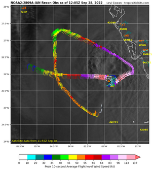
here's the power outage map

reconqq_NOAA2-2809A-IAN.png
 
83E088D6-5FBC-4C34-AE84-E3D998CDA75D.jpegPin drop is my city. We are definitely expecting some impact up here, but nothing like the Fort Myers and Southwest coast. So much devastation still to come. Heartbreaking.
 
@RetroQT I hope you guys don't have anything too terrible. I feel like my head is going to explode (but this is now a normal feeling...lol) I can see what looks like the sun up there through the clouds. its quiet right now but thats gonna change in about an hour I heard.
 
@RetroQT I hope you guys don't have anything too terrible. I feel like my head is going to explode (but this is now a normal feeling...lol) I can see what looks like the sun up there through the clouds. its quiet right now but thats gonna change in about an hour I heard.

So sorry you’re dealing with the physical pain as well as the storm. ((hugs))
 
GET 3 FREE HCA RESULTS JOIN THE FORUM. ASK FOR HELP
Top