shape
carat
color
clarity

Hurricane season: We got some stuff to watch (FL, Gulf, Eastern US)

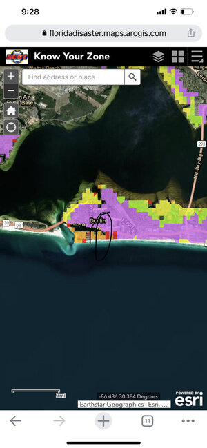
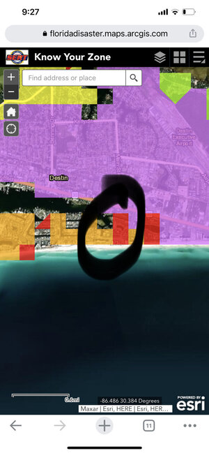
You are right @Arcadian ... No one is talking about the size (yet). It has moved a little west which is better for the peninsula of Florida but worse for the pan handle. Also looks like my parents place is still in play on the east side of the hurricane (which is bad of course). I sent them text yesterday about coming over to my place but haven't heard back yet. I hope it continues to move west. No matter where it hits it's going to be an issue though. I will continue to monitor the updates today because you never know.

Hope you're doing well and prep is on schedule for you.
 
some model runs are ticking east. even the GFS ticked east. I'm waiting for the update to NHC to post anything else.
 
some model runs are ticking east. even the GFS ticked east. I'm waiting for the update to NHC to post anything else.


Nooooo, ugh! I guess it is what it is. Picked up groceries this morning and looked like everyone was there stocking up.
 
B7F735FB-EA10-4A58-9888-98ABFFBCB93F.jpeg

Looks like I’m going shopping for the hurricane party (aka all the non-perishable junk food).
 
Nooooo, ugh! I guess it is what it is. Picked up groceries this morning and looked like everyone was there stocking up.

The biggest question still is how far east. Being so big, even if the eye stays off shore, east coast still feels it because the wind and rain, and if any of that convection blows off we'll get that too! It will likely be about Tropical storm force or less for some of us. (basically our afternoon storms...lol)

But when you take into account all the soaked ground the peninsula already has and we're going to get rain (again) which means trees fall and also power outages.

Unfortunately too many people get wrapped up in where the eye is and they think thats it, when its just not. Getting hit with eyewalls absolutely suck for sure, but so much damage takes place well outside the eye.... I really don't want to be without power again.

In this last track NHC is taking into account the dry air in the gulf if the storm moves further north by the pan handle. If the cold front stalls (which is the steering current), then the storm stalls, gets dry air in it and weakens. The storm gets trapped because the jetstream is too far north.

If the storm is strong and the jet stream moves east at the right amount before the storm hits the cold front and that dry air, it will cross the state to the east side.

But there's a lot of variables that are still unknown, so we're stuck with the NHC track because quite frankly, they don't know either. No model agreement.

In my opinion, for east coast FL its all about the rain and the storms and thats what I'm worried most about. Thats what it was with Irma. The winds were tropical force in my area but the rain/tornadoes/lighting is what did us in mostly. We've been under flood watches since last week as it is!

019
WTNT44 KNHC 251521 CCA
TCDAT4

Tropical Storm Ian Discussion Number 10...Corrected
NWS National Hurricane Center Miami FL AL092022
1100 AM EDT Sun Sep 25 2022

Corrected timing of Ian becoming a hurricane in the intensity
discussion below to tonight or early Monday.

The satellite presentation of Ian is gradually improving this
morning. The overall circulation appears better defined in visible
satellite imagery, and fragmented bands of convection around the
center are showing increased signs of curvature. The low-level
center of Ian also appears better defined in the latest data
collected by the NOAA and Air Force Hurricane Hunters. Although the
vortex is still vertically tilted, tail Doppler radar data suggest
the low- and mid-level centers are beginning to converge. An earlier
center dropsonde indicated the minimum pressure dropped slightly to
1001 mb, but the aircraft winds thus far have not reflected any
strengthening. Therefore, initial intensity for this advisory is
held at 45 kt.

The latest fixes suggest Ian is beginning to make its turn around
the western side of the subtropical ridge, and the initial motion
is west-northwestward at 290/12 kt. A gradual turn to the northwest
is expected later today as the cyclone passes well southwest of
Jamaica, followed by a north-northwestward motion that brings the
center of Ian west of the Cayman Islands on Monday and near or over
western Cuba by early Tuesday. There is relatively high confidence
in this portion of the track forecast. However, once the cyclone
emerges over the southeastern Gulf of Mexico, the spread in the
track guidance increases at days 3-5. The HWRF and GFS still lie on
the western side of the guidance envelope and show Ian moving over
the central or western Florida panhandle, while the ECMWF and UKMET

models show a track farther east into west-central Florida. Overall,
the NHC track forecast remains near the center of the guidance
envelope and still lies very near the TVCA multi-model consensus.
However, there is still significant uncertainty in the long-range
track forecast of Ian, and future adjustments to this portion of the
forecast will likely be required. :doh:


The atmospheric and oceanic conditions over the northwestern
Caribbean Sea appear very conducive for significant strengthening.
So once Ian becomes more organized, the high oceanic heat content
and low vertical shear conditions appear likely to support rapid
intensification. The Deterministic to Probabilistic Statistical
Rapid Intensification Index (DTOPS) still shows a greater than 90
percent chance of rapid strengthening during the next 2-3 days. The
intensity guidance remains very aggressive with strengthening Ian,
and the NHC forecast reflects this potential. Ian is expected to
become a hurricane by tonight or early Monday, and is forecast to
reach major hurricane strength before it reaches western Cuba. This
forecast lies very near the latest SHIPS guidance and the IVCN aid.
By day 4, a significant increase in southwesterly shear is forecast
by the global models, and this is forecast to induce some weakening
as the vertical structure of the hurricane is disrupted. Despite
this, Ian is likely to have an expanding wind field and will be
slowing down by that time, which will have the potential to produce
significant wind and storm surge impacts across portions of the
Florida west coast and the Florida panhandle.

Key Messages:

1. Ian is expected to produce heavy rainfall, flash flooding, and
possible mudslides in areas of higher terrain, particularly over
Jamaica and Cuba. Flash and urban flooding is possible across the
Florida Keys and Florida peninsula through mid week. Additional
flooding on rivers across northern Florida and parts of the
southeast U.S. cannot be ruled out later this week.

2. Life-threatening storm surge and hurricane-force winds are
expected in portions of western Cuba beginning late Monday, where
a hurricane warning is now in effect. Efforts to protect life and
property should be rushed to completion.

3. Ian is expected to be a major hurricane in the eastern Gulf of
Mexico during the middle of the week, but uncertainty in the
long-term track and intensity forecasts is higher than usual.
Regardless of Ian’s exact track and intensity, there is a risk of
dangerous storm surge, hurricane-force winds, and heavy rainfall
along the west coast of Florida and the Florida Panhandle by the
middle of the week, and residents in Florida should ensure they
have their hurricane plan in place, follow any advice given by
local officials, and closely monitor updates to the forecast.

FORECAST POSITIONS AND MAX WINDS

INIT 25/1500Z 15.2N 79.8W 45 KT 50 MPH
12H 26/0000Z 16.5N 81.1W 55 KT 65 MPH
24H 26/1200Z 18.1N 82.5W 70 KT 80 MPH
36H 27/0000Z 20.1N 83.7W 90 KT 105 MPH
48H 27/1200Z 22.0N 84.4W 105 KT 120 MPH
60H 28/0000Z 23.9N 84.8W 115 KT 130 MPH
72H 28/1200Z 25.5N 84.8W 115 KT 130 MPH
96H 29/1200Z 28.0N 84.4W 95 KT 110 MPH
120H 30/1200Z 30.3N 83.7W 65 KT 75 MPH...INLAND

$$
Forecaster Reinhart
 
The update then I'm going to bed. Shifted east. I won't be surprised if it shifts east again.

025518_5day_cone_no_line_and_wind.png

Remember that this is not a small storm, its very big, at 450+ miles wide. The Florida peninsula is ....not that wide.

So even if the eye were to stay off shore but were to be in the eastern side of the cone, this storm will cover the entire peninsula and its effects will be felt everywhere. As it is, anyone on the east side of this storm should take care and prepare. counter clockwise flow means that water will wash ashore, and there will be lots of rain and storms associated. We hope no tornadoes but mother nature does like to do her thing....


966
WTNT44 KNHC 260300
TCDAT4

Tropical Storm Ian Discussion Number 12
NWS National Hurricane Center Miami FL AL092022
1100 PM EDT Sun Sep 25 2022

The storm has become better organized-looking on satellite imagery,
with strengthening central convection and developing banding
features. Upper-level anticyclonic outflow also appears to be
increasing over the system. Flight-level winds, Doppler radar
velocities, and dropsonde data from a NOAA Hurricane Hunter aircraft
indicate that Ian's intensity is now near 55 kt.

Ian has turned toward the northwest and the initial motion estimate
is now 315/11 kt. During the next 48 hours, the tropical cyclone
is expected to turn toward the north as it moves along the western
side of a mid-level high pressure area. Later in the forecast
period, a broad mid-tropospheric trough over the eastern United
States is likely to induce a slightly east of northward motion.
However, around 4 days, the steering currents are forecast to
weaken as the trough moves to the east of Ian's longitude. Some
of the guidance model tracks such as that from the GFS have, again,
shifted to the east, mainly after 48 hours. The official track
forecast has been shifted somewhat to the east of the previous one
and is mainly a blend of the latest ECMWF and GFS predictions. It
should again be stressed that there is still significant
uncertainty in the track of Ian, especially in the 3-5 day time
frame. Users should not focus on the details of the track forecast
at longer time ranges.


Observations from the aircraft indicate that the tropical cyclone
is developing an inner core, so significant intensification is
likely to occur during the next couple of days. The SHIPS Rapid
Intensification Index indicate a fairly high chance for rapid
strengthening during the next 24 to 36 hours, and the official
forecast reflects this likelihood, calling for Ian to become a
major hurricane over the southeastern Gulf of Mexico.


Key Messages:

1. Ian is expected to produce heavy rainfall and instances of
flash flooding and possible mudslides in areas of higher terrain,
particularly over Jamaica and Cuba. Considerable flooding impacts
are possible later this week in west central Florida. Additional
flash and urban flooding, and flooding on rivers across the Florida
Peninsula and parts of the Southeast cannot be ruled out for later
this week.

2. Life-threatening storm surge and hurricane-force winds are
expected in portions of western Cuba beginning late Monday, and Ian
is forecast to be at or near major hurricane strength when it is
near western Cuba. Efforts to protect life and property should be
rushed to completion.

3. Ian is expected to be a major hurricane in the eastern Gulf of
Mexico during the middle of this week, but uncertainty in the track
and intensity forecasts remains higher than usual. Regardless of
Ian’s exact track and intensity, there is a risk of dangerous storm
surge, hurricane-force winds, and heavy rainfall along the west
coast of Florida and the Florida Panhandle by the middle of this
week, and residents in Florida should ensure they have their
hurricane plan in place. Follow any advice given by local officials
and closely monitor updates to the forecast.


FORECAST POSITIONS AND MAX WINDS

INIT 26/0300Z 17.3N 81.4W 55 KT 65 MPH
12H 26/1200Z 18.7N 82.3W 65 KT 75 MPH
24H 27/0000Z 20.8N 83.5W 85 KT 100 MPH
36H 27/1200Z 22.7N 84.0W 100 KT 115 MPH
48H 28/0000Z 24.7N 84.1W 105 KT 120 MPH
60H 28/1200Z 26.2N 83.8W 115 KT 130 MPH
72H 29/0000Z 27.6N 83.5W 105 KT 120 MPH
96H 30/0000Z 29.0N 83.2W 80 KT 90 MPH
120H 01/0000Z 32.0N 82.5W 40 KT 45 MPH...INLAND

$$
Forecaster Pasch
 
I am in Odessa, FL and 15 miles from the coast as the crow flies. Watching and waiting.
 
Keeping all who might be affected in my thoughts!!!
May everyone remain safe and may any damage be minimal.
 
@DiaLuv I'm very sorry to hear it and my heart goes out to you. Do you have a plan in place? Its setting up to be ugly on the west side.

Ian is now a hurricane and the pressure is starting to drop. I believe hurricane hunters are going in and out of there to get as much data as they can (which is always very cool!

Def. a good video by Dr Cowan last night that uses a lot of plain english to explain whats going on. BTW skies here are really something else. they look quite stormy, the air is very very wet.


000
WTNT44 KNHC 260858
TCDAT4

Hurricane Ian Discussion Number 13
NWS National Hurricane Center Miami FL AL092022
500 AM EDT Mon Sep 26 2022

Satellite imagery shows that Ian has quickly become better organized
overnight. Banding has increased in all quadrants of the storm, and
the eye has become much better defined in radar data from Grand
Cayman. The improving eye structure was also reported by an Air
Force Reserve reconnaissance aircraft that was in the storm
overnight. During a single pass through the northeastern portion
of the storm the plane measured peak 700-mb flight-level winds of 71
kt and SFMR winds of 57 kt. Given the continued increase in
organization and drop in central pressure on the latest center fix,
the initial intensity has been increased to 65 kt, making Ian the
fourth hurricane of the 2022 hurricane season. The latest center
drop from the aircraft supported a minimum pressure of 983 mb.


In addition to the development of an inner core, the upper-level
outflow over the storm has expanded overnight. Ian will be
traversing the warm waters (30 degrees C) of the northwestern
Caribbean and remain within very low shear conditions today. These
very conducive environmental factors along with the improved
structure of the storm are likely to result in rapid intensification
today, and Ian is forecast to be a major hurricane when it moves
near or over western Cuba tonight. This is supported by the
majority of the intensity guidance, and the SHIPS Rapid
Intensification (RI) Index that gives a 90 percent chance of a
30 kt increase in wind speed over the next 24 hours, and about a 60
percent chance of a 40 kt increase in wind speed during that same
period. Ian is not expected to spend much time over western Cuba,
and additional strengthening is likely over the southeastern Gulf
of Mexico on Tuesday. Around 60 hours, a sharp increase in
southwesterly vertical wind shear and a drier mid-level environment
to the northwest of Ian is likely to induce some weakening.
Despite the reduction in intensity, Ian is likely to have an
expanding wind field and will be slowing down by that time, which
will have the potential to produce significant wind and storm surge
impacts along the west coast of Florida.

The initial motion estimate is 325/12 kt. Ian is expected to turn
northward around the western side of a mid-level ridge during the
next day or so. Later in the period, a broad trough over the
eastern United States is forecast to induce a north-northeastward
motion, however the steering currents are forecast to weaken
around day 3, and a slower forward speed is expected by that time.
Although the track guidance is in good agreement during the first
48 hours, there is still significant spread after that time. The
UKMET and ECWMF are still on the eastern side of the guidance and
show a track very near or over the west-central coast of Florida
while the GFS, HWRF, and HMON, and GFS ensemble mean are on the
western side with a track toward Appalachia Bay. The NHC track
forecast remains close to the TVCA multi-model consensus aid, and
is very similar to the previous official forecast. It should again
be stressed that there is still significant uncertainty in the track
of Ian, especially in the 3-5 day time frame, and users should not
focus on the details of the track forecast at longer time ranges.


Key Messages:

1. Ian is expected to produce heavy rainfall and instances of
flash flooding and possible mudslides in areas of higher terrain,
particularly over Jamaica and Cuba. Considerable flooding impacts
are possible later this week in west central Florida. Additional
flash and urban flooding, and flooding on rivers across the Florida
Peninsula and parts of the Southeast cannot be ruled out for later
this week.

2. Life-threatening storm surge and hurricane-force winds are
expected in portions of western Cuba beginning late today, and
Ian is forecast to be at major hurricane strength when it is near
western Cuba. Efforts to protect life and property should be
rushed to completion.

3. Ian is expected to be a major hurricane in the eastern Gulf of
Mexico during the middle of this week. Regardless of Ian’s exact
track and intensity, there is a risk of a life-threatening storm
surge, hurricane-force winds, and heavy rainfall along the west
coast of Florida and the Florida Panhandle by the middle of this
week. Tropical Storm and Hurricane Watches have been issued for a
portion of the west coast of Florida and additional watches may be
required later today.


FORECAST POSITIONS AND MAX WINDS

INIT 26/0900Z 18.2N 82.0W 65 KT 75 MPH
12H 26/1800Z 19.7N 83.0W 90 KT 105 MPH
24H 27/0600Z 21.7N 83.9W 105 KT 120 MPH
36H 27/1800Z 23.6N 84.1W 115 KT 130 MPH
48H 28/0600Z 25.3N 84.1W 120 KT 140 MPH
60H 28/1800Z 26.7N 83.7W 115 KT 130 MPH
72H 29/0600Z 27.7N 83.4W 100 KT 115 MPH
96H 30/0600Z 29.2N 83.0W 80 KT 90 MPH
120H 01/0600Z 32.0N 82.9W 35 KT 40 MPH...INLAND

$$
Forecaster Brown/Roberts
 
Also sorry remiss of me but here's the image The storm starts to slow as its coming in unfortunately. And that slowness is whats going to be the worst of this.
1023413_3day_cone_no_line_and_wind.png


also some recon data

recon_AF300-1409A-IAN.png
 
Emergency Management for the state of FL: https://www.floridadisaster.org/dem/

While I'm 5 miles as the crows fly from the coast, I'm not in a flood zone or even an evac zone and though my home was born in 1961, she's been updated (like a lot!) so I'm good! And as much as I sometimes hate the freeway wall in all its very ugly glory, its also the safety net in these situations. I will probably lose electric though and that always sucks.

Anyway this is a particularly great link: https://www.floridadisaster.org/planprepare/know-your-zone-know-your-home/
 
@DiaLuv I'm very sorry to hear it and my heart goes out to you. Do you have a plan in place? Its setting up to be ugly on the west side.

Ian is now a hurricane and the pressure is starting to drop. I believe hurricane hunters are going in and out of there to get as much data as they can (which is always very cool!

Def. a good video by Dr Cowan last night that uses a lot of plain english to explain whats going on. BTW skies here are really something else. they look quite stormy, the air is very very wet.


Arcadian, we plan to put up our shutters, we have food and water. will ride it out. We have a newer home built to hurricane standards and live on raised lot.
 
Tampa Bay here. Will probably be a bit ugly but should be ok. Tomorrow we need to bring everything in that could be a flying object and I'll do a little food prep that can go in a cooler if we lose power.
 
Emergency Management for the state of FL: https://www.floridadisaster.org/dem/

While I'm 5 miles as the crows fly from the coast, I'm not in a flood zone or even an evac zone and though my home was born in 1961, she's been updated (like a lot!) so I'm good! And as much as I sometimes hate the freeway wall in all its very ugly glory, its also the safety net in these situations. I will probably lose electric though and that always sucks.

Anyway this is a particularly great link: https://www.floridadisaster.org/planprepare/know-your-zone-know-your-home/

So glad you’re not in a flood zone!!! The condo I rented IS…I really hope there isn’t any damage. I’m on floor 1 of 2 but the whole housing is obviously elevated. The zone pics are kind of hilarious because one of just a few red zones are right on top of where I’ll be staying (not this week, at least…)

Here in Indiana we just get tornados and flooding. Unfortunately we don’t get much warning for either. I did purchase travel insurance for my flight back because it was a lot more expensive than my flight down—if I have to cancel the first leg it won’t be a huge deal. And I would just lose my deposit on the condo if I have to cancel so not a major problem either.

Fingers crossed for everyone else down there! I have friends in several areas and always worry about them.
 

Attachments

  • E03A23CA-59B3-4BA8-9984-CC8175CE11E1.jpeg
    E03A23CA-59B3-4BA8-9984-CC8175CE11E1.jpeg
    105.4 KB · Views: 1
  • EB355E07-8CD6-485B-99EA-748A161002DC.jpeg
    EB355E07-8CD6-485B-99EA-748A161002DC.jpeg
    117.6 KB · Views: 1
3 day flood map 102341WPCQPF_sm.gif
 
Hoping that everyone stays safe and suffers no damage.
 

Dr Cowan just put out another video. BTW for those who want to know, he did a stint at NHC after he got his doctorate (tropicaltidbits.com was part of his thesis) and currently working at the Typhoon center in Hawaii. Dude knows his stuff.
 
We're starting to get those outer bands now in my area. oh boy. and of course I've got one hell of a headache. storm is currently a 972(??) MB and Ian is a very big boy.

I've been a bit busy so haven't been looking much but looks more east?

163741_5day_cone_no_line_and_wind.png
99
WTNT44 KNHC 262102 CCA
TCDAT4

Hurricane Ian Discussion Number 15...Corrected
NWS National Hurricane Center Miami FL AL092022
500 PM EDT Mon Sep 26 2022

Corrected header

Ian continues to strengthen over the northwestern Caribbean Sea. The
last report from the Air Force Hurricane Hunters around 1630 UTC
found 700-mb flight-level winds of 79 kt. The inner core appears
better organized, and the eyewall structure has greatly improved in
radar imagery from the Cayman Islands. The 18 UTC satellite
classifications from SAB and TAFB were a consensus T4.5/77 kt, but
the continued improvement in satellite structure warrants raising
the initial intensity to 85 kt for this advisory.

Atmospheric and oceanic conditions remain very favorable for
additional intensification during the next 24 h or so, as Ian moves
over the very warm waters of the northwestern Caribbean Sea and the
southeastern Gulf of Mexico while the shear remains quite low. The
NHC intensity forecast calls for Ian to become a major hurricane
before it reaches western Cuba early Tuesday. It is then forecast to
reach its peak intensity over the southeastern Gulf of Mexico in 36
h. After that, southwesterly shear in association with a deep-layer
trough over the eastern U.S. is forecast to significantly increase
over the hurricane on Wednesday and Thursday, which will likely
disrupt the vertical structure and import drier air into its
circulation. Despite these less favorable conditions, Ian is still
forecast to remain at or near major hurricane strength as it passes
near the west-central coast of Florida on Wednesday and Thursday.
The NHC intensity forecast agrees well with the latest IVCN and HCCA
aids.

Ian has made an expected turn toward the north-northwest, and its
initial motion is 330/11 kt. The hurricane will move
north-northwestward to northward over the next day or so as it is
steered by a mid-level ridge to the east. A turn to the
north-northeast with a decrease in forward speed is forecast on
Wednesday and Thursday as the center of Ian moves near the west
coast of Florida. The slower forward motion is likely to prolong the
storm surge, wind, and rainfall impacts, especially along the west
coast of Florida.
The latest track guidance has come into better
agreement on this scenario, although it is noted that small
deviations to the shore-parallel track could have large implications
on the impacts at particular locations along the west coast of
Florida. The NHC track forecast has again been adjusted slightly
eastward at 48-72 h, which follows the latest trends in the global
model guidance and lies near but just west of the multi-model
consensus aids.


Based on the latest forecast and timing of expected impacts,
Hurricane and Storm Surge Warnings have been issued along the west
coast of Florida.


Key Messages:

1. Life-threatening storm surge, hurricane-force winds, flash
floods and possible mudslides are expected in portions of western
Cuba beginning this evening and continuing into Tuesday.
Devastating wind damage is possible where the core of Ian moves
across western Cuba. Efforts to protect life and property should be
rushed to completion.

2. There is the danger of life-threatening storm surge along much
of the Florida west coast where a storm surge warning has been
issued, with the highest risk from Fort Myers to the Tampa Bay
region. Residents in these areas should listen to advice given by
local officials.

3. Hurricane-force winds are expected in the hurricane warning area
in west-central Florida beginning Wednesday morning with tropical
storm conditions expected by late Tuesday.

4. Heavy rainfall will increase across the Florida Keys and south
Florida Tuesday, spreading to central and northern Florida Wednesday
and Thursday, potentially causing flash, urban and small stream
flooding. Significant prolonged river flooding is likely across
central Florida.


FORECAST POSITIONS AND MAX WINDS

INIT 26/2100Z 20.3N 83.2W 85 KT 100 MPH
12H 27/0600Z 21.7N 83.8W 105 KT 120 MPH
24H 27/1800Z 23.6N 84.0W 115 KT 130 MPH
36H 28/0600Z 25.3N 83.9W 120 KT 140 MPH
48H 28/1800Z 26.7N 83.5W 115 KT 130 MPH
60H 29/0600Z 27.5N 83.2W 100 KT 115 MPH
72H 29/1800Z 28.1N 82.9W 75 KT 85 MPH
96H 30/1800Z 30.1N 82.3W 45 KT 50 MPH...INLAND
120H 01/1800Z 33.5N 82.0W 25 KT 30 MPH...INLAND

$$
Forecaster Reinhart
 

Dr Cowan just put out another video. BTW for those who want to know, he did a stint at NHC after he got his doctorate (tropicaltidbits.com was part of his thesis) and currently working at the Typhoon center in Hawaii. Dude knows his stuff.

Oh no! That looks pretty fierce. Sending you all strong vibes for staying safe!!
 
FFA0707D-7AE3-4C3F-A584-3BD0824780D2.jpeg
 
Ugh. It's looking more like Tampa Bay is in play in a large way. I'm supposed to be in trial the next two weeks. I'm really hoping the judges don't force them forward after the storm immediately because that will be a giant mess...
 
So I don't know if anyone else has a headache but I certainly do. We've gotten some bands this evening and the rain will be picking up more overnight. I'm trying to hang on until 11pm advisory but I'm pretty tired.
 
So I don't know if anyone else has a headache but I certainly do. We've gotten some bands this evening and the rain will be picking up more overnight. I'm trying to hang on until 11pm advisory but I'm pretty tired.

I have had a headache all evening. We actually had to drain a bunch of water from the pool already.
 
I understand the headache thing. I get barometric headaches and actually got one Friday as Fiona was passing up my way. Luckily they seem to go away once the pressure changes. But they are some of the worst headaches that I ever get. I hope you both feel better.
 
There's a small track change pushing more east earlier. I'm now in bed, its raining like crazy, head wants 2 explode.
 
Thank you @Arcadian for keeping everyone here updated on this storm. Please stay everyone. I’m sorry about the headaches Arcadian. As if going thru a hurricane isn‘t bad enough, you don’t need the extra bonus of a headache too. @Arcadian , @tyty333 , @elizat , @QT Retro and @DiaLuv, Please stay safe. I’ll be thinking of you all and sending well wishes.

@Arcadian, I remember the time you were without power for three days. Hopefully the power won’t be out for long.
 
my prayers that all of you in path of this hurricane stay safe, I know many people in florida on both the west coast and the east coast, one of them being in the tampa area and I pray they stay safe as well!
 
I love you guys. I'm awake, its calm out and but my head is really banging right now. Storm is currently 952MB and wind speeds are 100MPH. Fiona gave me auras, Its unfortunate but these are/were also very big storms.

We got lots of wet nasty squalls last evening. There's an 0800 advisory, but this I believe now shows in a pretty locked in track. If time allows I will go to the beach to see how bad it is...thats before its NOT allowed! There's lots of turtle nests this time of year with some just at the cusp of starting to hatch. sadly I think a lot of them will get washed away.
0421481_5day_cone_no_line_and_wind.png

There's only one more shift this thing could do and that depends on the upper ridge. I don't see that happening though. This is gonna be really serious for Tampa Area because this thing barely moves Wed/Thursday.

Be safe folks and please keep in touch.


000
WTNT44 KNHC 270858
TCDAT4

Hurricane Ian Discussion Number 17
NWS National Hurricane Center Miami FL AL092022
500 AM EDT Tue Sep 27 2022

Ian's satellite presentation continued to improve up until the
center reached the coast of western Cuba around 0830 UTC. An Air
Force Reserve reconnaissance aircraft that was in the storm until
around 0400 UTC reported peak 700-mb flight-level winds of 101 kt,
and a peak SFMR wind of 97 kt. During the final pass through the
center, dropsonde data supported a minimum pressure of 960 mb.
Given the continued improvement in satellite imagery, Dvorak data
T-numbers from SAB and TAFB of T5.5 (102 kt), and objective
estimates from UW/CIMSS of T5.4 (100 kt), the intensity was
increased to 100 kt shortly after 0600 UTC. The latest objective
Dvorak estimates have increased to around 110 kt, and that is the
estimated landfall intensity and initial intensity for this
advisory. NOAA and Air Force Reserve reconnaissance aircraft are
scheduled to investigate the storm as it moves off the northern
coast of Cuba this morning.

Ian is expected to spend only spend a few hours over western Cuba,
and little overall change in strength is likely during that time.
The center should emerge over the southeastern Gulf of Mexico later
this morning, where warm water and generally low vertical wind shear
conditions are expected to allow for additional intensification, and
the NHC forecast calls for Ian to reach category 4 strength. By 24
to 36 hours, increasing southwesterly vertical wind shear and drier
mid-level air are likely to result in some gradual weakening.
However, Ian is still expected to be a major hurricane when it
reaches the Florida west coast. The official intensity forecast is
near the latest simple and corrected multi-model consensus
predictions.

Ian has turned northward and is moving 355/10 kt. The hurricane
should continue on a northward motion today around the western
periphery of a subtropical ridge. After that time, a broad trough
over the eastern United States is expected to cause a
north-northeastward turn. There continues to be larger-than-normal
spread in the track guidance by 36-48 hours, however the trend in
the global models has been more southward and eastward over the
last cycle or two. As a result, the NHC track has been adjusted to
the southeast of the previous forecast and it lies just west of the
TVCA multi-model consensus aid. Users are reminded to not focus on
the exact track as some additional adjustments to the track are
possible, and wind, storm surge, and rainfall hazards will extend
far from the center. The updated forecast track has necessitated
several changes to the warnings and watches across the Florida Keys
and Florida peninsula, including an extension of the Hurricane
Warning southward to Bonita Beach on the west coast.

Key Messages:

1. Life-threatening storm surge, hurricane-force winds, flash
floods and possible mudslides are expected in portions of western
Cuba today. Devastating wind damage is expected where the core of
Ian moves across western Cuba this morning.

2. There is a danger of life-threatening storm surge along much
of the Florida west coast where a storm surge warning has been
issued, with the highest risk from Fort Myers to the Tampa Bay
region. Residents in these areas should listen to advice given by
local officials.

3. Hurricane-force winds are expected in the hurricane warning area
in west-central Florida beginning Wednesday morning with tropical
storm conditions expected by late today.

4. Heavy rainfall will spread across western Cuba through Tuesday.
This will likely produce instances of flash flooding and possible
mudslides in areas of higher terrain over western Cuba.

5. Heavy rainfall will increase across the Florida Keys and South
Florida Tuesday, spreading into central to northern Florida
Wednesday and Thursday, and the Southeast by Friday and Saturday,
likely causing flash, urban, and small stream flooding.
Considerable flooding is expected across Central Florida into
southern Georgia and coastal South Carolina, with significant,
prolonged river flooding expected across central to northern
Florida.


FORECAST POSITIONS AND MAX WINDS

INIT 27/0900Z 22.3N 83.7W 110 KT 125 MPH
12H 27/1800Z 23.7N 83.7W 120 KT 140 MPH
24H 28/0600Z 25.4N 83.5W 115 KT 130 MPH
36H 28/1800Z 26.7N 83.1W 110 KT 125 MPH
48H 29/0600Z 27.6N 82.6W 105 KT 120 MPH
60H 29/1800Z 28.3N 82.2W 75 KT 85 MPH...INLAND
72H 30/0600Z 29.0N 82.0W 55 KT 65 MPH...INLAND
96H 01/0600Z 31.7N 82.2W 30 KT 35 MPH...INLAND
120H 02/0600Z 35.0N 82.0W 25 KT 30 MPH...INLAND
 
Thank you @Arcadian for keeping everyone here updated on this storm. Please stay everyone. I’m sorry about the headaches Arcadian. As if going thru a hurricane isn‘t bad enough, you don’t need the extra bonus of a headache too. @Arcadian , @tyty333 , @elizat , @QT Retro and @DiaLuv, Please stay safe. I’ll be thinking of you all and sending well wishes.

@Arcadian, I remember the time you were without power for three days. Hopefully the power won’t be out for long.

My MIL won’t evacuate up here (we are in NE FL). Her house is not prepared to withstand a Cat3 hurricane and she’s on the coast just a stone’s throw from Tampa so it’s pretty much a direct hit for her. Prayers for her safety and that her home holds true for her.

For us, this time we are on the opposite side of the state and are expecting more of a tropical storm as it is expected to weaken greatly crossing land.
 
I am continuing to keep everyone in my thoughts and I am hoping hard the storm weakens in severity. My heart goes out to all affected and I am stressed out for you. Big hugs and well wishes. Please stay safe. And those poor turtles @Arcadian oh no :(
 
GET 3 FREE HCA RESULTS JOIN THE FORUM. ASK FOR HELP
Top