shape
carat
color
clarity

Storm Idalia

Arcadian

Ideal_Rock
Premium
Joined
Sep 17, 2008
Messages
9,390
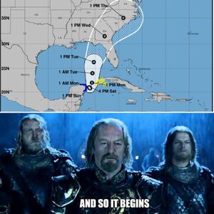
There's going to be updates at 5pm but heres whats going on. Pray for a nothing burger, but this is a full on something.

State of Emergency Issued for 33 Counties in Florida If you know anyone in these counties, please tell them to start preparing, they have at best 2.5 days.

Alachua County
Bay County
Calhoun County
Charlotte County
Citrus County
Columbia County
DeSoto County
Dixie County
Franklin County
Gadsden County
Gilchrist County
Gulf County
Hamilton County
Hardee County
Hernando County
Hillsborough County
Jefferson County
Lafayette County
Lee County
Leon County
Levy County
Liberty County
Madison County
Manatee County
Marion County
Pasco County
Pinellas County
Polk County
Sarasota County
Sumter County
Suwannee County
Taylor County
Wakulla County

I will update when there's more official news.
 
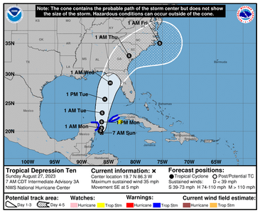
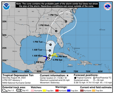
Tropical Depression 10, Future Idalia
205449_5day_cone_no_line_and_wind.png

000
WTNT45 KNHC 262053
TCDAT5

Tropical Depression Ten Discussion Number 1
NWS National Hurricane Center Miami FL AL102023
400 PM CDT Sat Aug 26 2023

The cloud pattern of the low pressure area located near the
northeastern Yucatan Peninsula of Mexico has gradually become
better organized today. Radar observations show a circulation has
developed, although surface observations indicate that the western
semicircle of this circulation is rather weak at this time. Given
the increased organization, advisories are being initiated on
Tropical Depression Ten. Surface synoptic observations suggest that
the current intensity is around 25 kt.

The current motion estimate is nearly stationary. There is a
weakness in the subtropical ridge to the north of the tropical
cyclone, leaving the system in a region of very weak steering flow.
The dynamical guidance indicates that the system will remain in
weak steering currents for the next 24 to 36 hours, so very little
motion is predicted during that period. After that time, a
mid-level ridge begins to build to the east of the tropical cyclone.
This should cause a generally northward motion in the next 2 to 3
days. Then, a gradual turn to the north-northeast is expected as
the system moves along the northwestern periphery of the ridge. The
official track forecast is a blend of the simple and corrected
dynamical model consensus guidance.

The tropical cyclone will be moving over very warm waters with only
moderate vertical wind shear anticipated during the next several
days. Therefore, gradual strengthening is forecast. The official
forecast is similar to the latest LGEM guidance and shows the
system becoming a hurricane over the eastern Gulf of Mexico. Users
are reminded that there is significant uncertainty in 3-4 day
intensity predictions and are urged to monitor changes to future
forecasts.


KEY MESSAGES:

1. Heavy rainfall from Tropical Depression Ten is expected across
the eastern Yucatan Peninsula and western Cuba. The heavy rainfall
may produce areas of flash and urban flooding, as well as
landslides, across western Cuba. The depression is forecast to
become a tropical storm by Sunday, and tropical storm conditions are
expected over portions of the Yucatan Peninsula where a Tropical
Storm Warning is in effect. Tropical storm conditions are possible
over portions of western Cuba within the Tropical Storm Watch area.

2. The depression is forecast to strengthen during the next few days
and could become a hurricane over the eastern Gulf of Mexico,
bringing a potential of dangerous storm surge, heavy rainfall, and
strong winds to portions of the west coast of Florida and the
Florida Panhandle by the middle of next week. Heavy rainfall is
also likely to spread into portions of the Southeast U.S. by mid to
late next week. Although it is too soon to specify the exact
location and magnitude of these impacts, residents in these areas
should monitor updates to the forecast of this system and ensure
that they have their hurricane plan in place.


FORECAST POSITIONS AND MAX WINDS

INIT 26/2100Z 21.1N 86.1W 25 KT 30 MPH
12H 27/0600Z 21.0N 86.3W 30 KT 35 MPH
24H 27/1800Z 20.9N 86.2W 35 KT 40 MPH
36H 28/0600Z 20.8N 86.1W 40 KT 45 MPH
48H 28/1800Z 22.0N 85.7W 45 KT 50 MPH
60H 29/0600Z 24.0N 85.6W 50 KT 60 MPH
72H 29/1800Z 26.3N 85.3W 65 KT 75 MPH
96H 30/1800Z 31.5N 83.0W 45 KT 50 MPH...INLAND
120H 31/1800Z 35.0N 79.0W 30 KT 35 MPH...INLAND

$$
Forecaster Pasch
 
701C6AEE-DA12-47D7-8F8B-33C9E10F3A3F.jpeg
 
UGH, storms that travel this path usually dump ALOT of rain as it travels through the Eastern Seaboard states.
 
I posted in the last storm thread toward the end about this one, knowing it could be something because of where it was going to be.

Hurricane hunters will be out tomorrow so there's going to be additional data to digest. in a weird way folks are flying blind so to speak. Storm is at a literal stand still, just in that gulf stream getting stronger. Thats a bit scary. there's some thought it could strengthen but this close out one just never knows.

Dr. Cowan of course explains this stuff way better than I can.


As long as it dosen't do anything expected, South Florida should be fine. We'll get some wind and some rain and some feeder bands because its a big storm, but will not suck as bad as the gulf side.

If it changes direction and comes across the state sooner, it could suck to be us.
 
Good morning and happy Sunday.

Hurricane Hunters are in the storm now so we'll know more by noonish
https://www.tropicaltidbits.com/recon/

However, the models are troubling and so is this discussion:


ZCZC MIATCDAT5 ALL
TTAA00 KNHC DDHHMM

Tropical Depression Ten Discussion Number 3
NWS National Hurricane Center Miami FL AL102023
400 AM CDT Sun Aug 27 2023

The small circulation of Tropical Depression Ten continues to be
well-defined in Cancun radar, with the center moving across Cozumel
during the past few hours. Data from a Weatherflow sensor on the
island indicated that the pressure dropped to about 1001 mb, with
sustained winds of about 30 kt. A small burst of convection has
formed just south of the center recently, with scattered banding
features in the eastern semicircle. Most of the satellite
estimates are just shy of tropical storm strength, so the initial
winds speed will stay 30 kt.
Both Air Force Reserve and NOAA
Hurricane Hunter aircraft will be in the system later this morning
to get a better look at the structure and winds.

The depression has turned southward tonight, moving at about 4 kt,
apparently rotating around the western periphery of its larger
parent circulation to the east. Little net motion is expected for
about a day as steering currents remain weak. After that time, a
developing trough over the Gulf of Mexico and stronger ridging over
the western Atlantic is expected to lift the system toward the north
and north-northeast over the eastern Gulf of Mexico.
This track
takes the system toward Florida, and then near the southeastern
coast of the U.S. The overnight model guidance is a bit farther
west and slower than the last cycle, probably due to the depression
being further south than anticipated. Thus, the NHC forecast is
nudged westward, and lies on the east side of the guidance envelope.
These are small changes overall, and the track should be considered
lower confidence until it starts moving in a more consistent manner.
The NOAA G-IV aircraft should be in the area this afternoon to
help smooth out the model differences along with special upper-air
soundings scheduled across many areas of the southeastern United
States.


The very warm and deep waters of the northwestern Caribbean Sea and
Gulf of Mexico should support at least gradual strengthening during
the next few days, tempered by moderate shear from a flat upper-
level trough. However, this trough is forecast to amplify over the
western Gulf of Mexico around Tuesday, which causes the shear to
decrease near the cyclone in that time frame. There's a notable
risk of rapid intensification while the system moves across the
record warm eastern and northeastern Gulf of Mexico, which is
highlighted by the recent HAFS and HWRF guidance. The new NHC
forecast is raised from the previous one, near or above the model
consensus, and could be too low. I'm reluctant to make any big
changes to the forecast until we get more in-situ data, but the
upward overnight model trend certainly bears watching. Users are
reminded to continue monitoring forecasts for any changes to the
system's expected intensity as it approaches Florida.


KEY MESSAGES:

1. Heavy rainfall from Tropical Depression Ten is expected across
the eastern Yucatan Peninsula and western Cuba. The heavy rainfall
may produce areas of flash and urban flooding, as well as
landslides, across western Cuba. The depression is forecast to
become a tropical storm later today, and tropical storm conditions
are expected over portions of the Yucatan Peninsula and extreme
western Cuba where a Tropical Storm Warning is in effect. Tropical
storm conditions are possible on the Isle of Youth, where a Tropical
Storm Watch is in effect.

2. The depression is forecast to strengthen during the next few days
and could become a hurricane over the eastern Gulf of Mexico,
bringing a potential of dangerous storm surge, heavy rainfall, and
strong winds to portions of the west coast of Florida and the
Florida Panhandle by the middle of this week. Heavy rainfall is
also likely to spread into portions of the Southeast U.S. by mid to
late week. Although it is too soon to specify the exact location
and magnitude of these impacts, residents in these areas should
monitor updates to the forecast of this system and ensure that they
have their hurricane plan in place.


FORECAST POSITIONS AND MAX WINDS

INIT 27/0900Z 20.1N 86.8W 30 KT 35 MPH
12H 27/1800Z 20.1N 86.5W 40 KT 45 MPH
24H 28/0600Z 20.6N 86.3W 45 KT 50 MPH
36H 28/1800Z 21.7N 86.3W 50 KT 60 MPH
48H 29/0600Z 23.3N 86.2W 60 KT 70 MPH
60H 29/1800Z 25.7N 85.7W 75 KT 85 MPH
72H 30/0600Z 28.5N 84.7W 80 KT 90 MPH

96H 31/0600Z 33.0N 81.2W 45 KT 50 MPH...INLAND
120H 01/0600Z 35.0N 75.5W 35 KT 40 MPH...OVER WATER

$$
Forecaster Blake
 
Sorry, didn't get the pic up!
115631_5day_cone_no_line_and_wind.png
 
We have Idalia. I'm not loving this track change. This is very bad for the peninsula and areas still recovering from Ian. NHC is being conservative for now and I belive its because they need more aircraft data.

Please remember the cone is only where the NHC predicts where the eye will be. Being that being such a large storm, the worst parts will be happening well outside the eye. The east side of the eyewall is always the dirty side as tropical systems rotate counter clockwise.

Still, shift east is not good as it means when it comes out the other side, the eye has possibility to be back over gulf stream water which is very warm.

The only thing thats good about this storm is that they're predicting it to move at a pretty fast clip once it gets going.
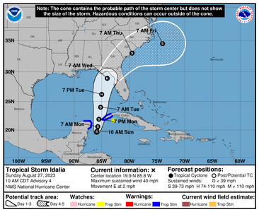
153810_5day_cone_no_line_and_wind.png

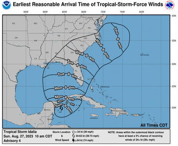
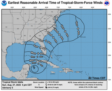
153810_earliest_reasonable_toa_no_wsp_34.png


000
WTNT45 KNHC 271500
TCDAT5

Tropical Depression Ten Discussion Number 4
NWS National Hurricane Center Miami FL AL102023
1000 AM CDT Sun Aug 27 2023

So far this morning, the overall cloud pattern of the tropical
cyclone has not become significantly better organized. The small
center is partially exposed on GOES-16 visible imagery, and
convective banding features are still not very well defined. The
current intensity is held at 30 kt for this advisory which is in
line with the latest Dvorak Satellite estimates. A NOAA Hurricane
Hunter aircraft, flying at around 12000 ft, is near the center of
the system taking Doppler radar wind velocity measurements. These
data should provide valuable information on the structure of the
cyclone for initializing the numerical weather prediction models.


The center of the cyclone appears to have been moving in a small
clockwise loop overnight and into this morning, and it will
probably complete this loop today. The initial motion estimate is
now around 090/2 kt. Steering currents should remain weak through
today and tonight. Beginning on Monday, a mid-level ridge starts to
build near southern Florida and eastward. This evolution should
cause a generally northward motion during the next couple of days.
In 48 to 72 hours, a mid-level trough dropping into the eastern U.S.
will likely induce a turn toward the north-northeast and take the
system across the northeast Gulf of Mexico coast on Wednesday. The
official forecast track has been nudged to the right of the
previous one, but is not quite as far east as the latest corrected
consensus, HCCA, prediction. Users are reminded not to focus on
the exact forecast track, since strong winds, heavy rains and
dangerous storm surges extend well away from the center.


The cyclone will be moving over waters of high oceanic heat content
over the eastern Gulf of Mexico and within a moist mid- to
low-level air mass for the next few days. An upper-tropospheric
trough is predicted to develop over the western Gulf of Mexico in 48
to 72 hours. Although this feature could produce some moderate
southwesterly vertical wind shear over the system, positive
vorticity advection and diffluent upper-level flow to the east of
the trough will likely be conducive for strengthening.
The
official forecast, like the previous one, calls for the cyclone to
reach hurricane status over the eastern Gulf of Mexico in 48 to 72
hours. This is at the high end of the latest intensity model
guidance.


KEY MESSAGES:

1. The depression is forecast to become a hurricane over the eastern
Gulf of Mexico, and there is an increasing risk of life-threatening
storm surge, flooding from heavy rainfall, and hurricane-force winds
along portions of the west coast of Florida and the Florida
Panhandle beginning as early as Tuesday. Although it is too soon
to specify the exact location and magnitude of these impacts,
residents in these areas should monitor updates to the forecast,
have their hurricane plan in place, and follow any advice given by
local officials. Storm surge and hurricane watches may be required
for portions of the Gulf coast of Florida later today.

2. Heavy rainfall is expected across the eastern Yucatan Peninsula
and western Cuba and may produce areas of flash and urban flooding
and landslides across western Cuba. The depression is forecast to
become a tropical storm later today, and tropical storm conditions
are expected over portions of the Yucatan Peninsula and extreme
western Cuba with tropical storm conditions possible on the Isle of
Youth.

3. Scattered flooding from heavy rainfall is likely over in
portions of the southeast U.S. by mid to late week.


FORECAST POSITIONS AND MAX WINDS

INIT 27/1500Z 19.9N 85.8W 30 KT 35 MPH
12H 28/0000Z 19.7N 85.9W 40 KT 45 MPH
24H 28/1200Z 20.6N 85.7W 45 KT 50 MPH
36H 29/0000Z 21.9N 85.5W 50 KT 60 MPH
48H 29/1200Z 24.0N 85.2W 60 KT 70 MPH
60H 30/0000Z 26.2N 85.0W 75 KT 85 MPH
72H 30/1200Z 28.9N 84.0W 80 KT 90 MPH
96H 31/1200Z 33.0N 79.5W 45 KT 50 MPH...INLAND
120H 01/1200Z 34.5N 74.0W 45 KT 50 MPH...OVER WATER


$$
Forecaster Pasch
 
I’m also in Duval county. Our house is a street away from the house that sit on the water.

We live in south Jax Beach sitting right in the center of the cone on the latest run… hope it moves. Full moon and a high tide will not be good for downtown or the Intercoastal.
 
Trend to the east.
174602_5day_cone_no_line_and_wind.png
210135_earliest_reasonable_toa_no_wsp_34.png
00
WTNT45 KNHC 272059
TCDAT5

Tropical Storm Idalia Discussion Number 5
NWS National Hurricane Center Miami FL AL102023
400 PM CDT Sun Aug 27 2023

Idalia's cloud pattern is gradually becoming a little better
organized, with a curved convective band forming over the southern
semicircle of the circulation. Upper-level outflow is currently
restricted over the northern portion of the system, however.
The advisory intensity is held at 35 kt based on a subjective
Dvorak estimate from TAFB. Another aircraft reconnaissance mission
into the storm is scheduled for tonight.

The tropical cyclone continues to move rather slowly, and the
initial motion estimate is 040/3 kt. Idalia should remain in a weak
steering pattern through tonight so slow and possibly erratic
motion is likely for the next 12 hours. On Monday, a mid-level
ridge begins to build to the northeast of the tropical cyclone.
This should result in a slightly east of northward motion during
the next day or two. When the system moves into the northeast Gulf
of Mexico, a mid-level trough developing over the eastern United
states will likely cause Idalia to turn northeastward with an
increase in forward speed. The new official forecast is again
shifted slightly eastward, and is somewhat faster than the previous
one. This is a blend of the latest ECMWF and GFS solutions and is
also between the simple and corrected dynamical consensus tracks.


The intensity forecast is somewhat challenging. Idalia will be
traversing eastern Gulf of Mexico waters of high oceanic heat
content, and the environmental air mass should remain fairly moist.
The flow to the east of an upper-level trough could impart some
vertical wind shear over the system, but this shear could also be
compensated by the conducive effect of upper-level diffluence.
There is considerable spread in the model intensity guidance,
ranging from minimal to major hurricane status before landfall on
the northeast Gulf coast. The official intensity forecast is a
little higher than the previous one, and remains near the higher
end of the guidance. Given the uncertainties, users should monitor
future NHC forecasts for possible changes in the predicted strength
of Idalia, and prepare for possible significant impacts within the
hurricane and storm surge watch areas.


KEY MESSAGES:

1. Idalia is forecast to become a hurricane over the eastern Gulf of
Mexico, and there is an increasing risk of life-threatening storm
surge and hurricane-force winds along portions of the west coast of
Florida and the Florida Panhandle beginning as early as Tuesday.
Although it is too soon to specify the exact location and magnitude
of these impacts, residents in these areas should monitor updates to
the forecast and follow any advice given by local officials. Storm
surge and hurricane watches have been issued for portions of the
west coast of Florida and the coast of the Florida Panhandle, and
residents in these areas should monitor updates to the forecast and
follow any advice given by local officials.

2. Scattered flash and urban flooding can be expected across
portions of the west coast of Florida, the Florida Panhandle and
portions of the Southeast U.S. by Tuesday into Thursday. Flooding
from heavy rainfall is likely over portions of the southeast U.S. by
mid to late week.

3. Heavy rainfall from Tropical Storm Idalia is expected across
portions of the eastern Yucatan and western Cuba and may produce
areas of flash and urban flooding as well as landslides across
western Cuba.

4. Tropical storm conditions are expected over portions of the
Yucatan Peninsula and extreme western Cuba with tropical storm
conditions possible on the Isle of Youth.


FORECAST POSITIONS AND MAX WINDS

INIT 27/2100Z 20.1N 85.5W 35 KT 40 MPH
12H 28/0600Z 20.5N 85.3W 45 KT 50 MPH
24H 28/1800Z 21.7N 85.0W 55 KT 65 MPH
36H 29/0600Z 23.4N 84.9W 65 KT 75 MPH
48H 29/1800Z 25.6N 84.5W 75 KT 85 MPH
60H 30/0600Z 28.7N 83.7W 85 KT 100 MPH

72H 30/1800Z 31.3N 81.9W 50 KT 60 MPH...INLAND
96H 31/1800Z 34.5N 76.0W 50 KT 60 MPH...OVER WATER
120H 01/1800Z 35.0N 71.0W 55 KT 65 MPH

$$
Forecaster Pasch
 
I worry about those close to St Johns and what thats going to do with this super full moon coming + a storm.
 
Thanks for all the updates I’m keeping an eye
 
I don't know if anyone else feels it but the pressure is immense. Franklin on one side, Idalia on the other, my head is in the middle and feeling like it wants to explode (not typical that I get nausea but yeah its very high right now)

I will post the 11pm update if its anything major. I'm going to go lay down and try to relax (this is an evening for MM y'all)
 
11pm advisory

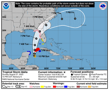
025839_5day_cone_no_line_and_wind.png


000
WTNT45 KNHC 280257
TCDAT5

Tropical Storm Idalia Discussion Number 6
NWS National Hurricane Center Miami FL AL102023
1000 PM CDT Sun Aug 27 2023

Idalia's center has become embedded beneath a large burst of deep
convection, with overshooting cloud-top temperatures as cold as -82
degrees Celsius. NOAA buoy 42056, located just to the east of the
center, has reported maximum 1-minute sustained winds as high as 45
kt within the past hour or two.
The anemometer height of the buoy
is 4 meters, so converting the wind to a standard 10-meter height
indicates that Idalia's intensity is now up to at least 50 kt, which
is the initial intensity for this advisory. An Air Force Reserve
reconnaissance aircraft is scheduled to investigate Idalia in a few
hours.


The center has been moving erratically since earlier today, and may
have even sagged southward, pulled toward the recently developed
deep convection. A northward motion is expected to begin on Monday
and continue through Tuesday as Idalia moves between a mid-level
trough over the central Gulf of Mexico and strengthening ridging
over the Greater Antilles. After 48 hours, a gradual turn toward
the northeast and then east is anticipated due to a deeper trough
that is expected to swing across the Great Lakes. No significant
changes were required for the updated NHC track forecast compared
to the previous prediction. The spread among the track models
remains relatively low, and the official track continues to lie
closest to the ECMWF and HCCA consensus aid.

Idalia is sitting over very warm waters of about 30 degrees
Celsius
, and when it moves northward, it will be over the even
deeper warm waters of the Loop Current in 24-36 hours. Although
the trough over the Gulf could impart some shear over the system,
this is likely to be offset by upper-level diffluence. Idalia has
already strengthened more than anticipated, and the environment
looks ripe for additional intensification, possibly rapid.
The NHC
intensity forecast has been increased and lies at the upper bound of
the guidance. The new prediction now shows a 95-kt hurricane over
the eastern Gulf of Mexico at 48 hours, but it should be stressed
that additional strengthening to major hurricane strength is
becoming increasingly likely before Idalia reaches the Gulf coast
of Florida. Interests within the storm surge and hurricane watch
areas are urged to prepare for possible significant impacts and
monitor future updates to the forecast.


KEY MESSAGES:

1. Idalia is forecast to become a hurricane by the time it reaches
the southeastern Gulf of Mexico, and it could be near or at major
hurricane strength when it reaches the Gulf coast of Florida. The
risk continues to increase for a life-threatening storm surge and
hurricane-force winds along portions of the west coast of Florida
and the Florida Panhandle beginning as early as Tuesday. Storm
surge and hurricane watches are in effect for portions of the
west coast of Florida and the coast of the Florida Panhandle, and
residents in these areas should monitor updates to the forecast and
follow any advice given by local officials.

2. Scattered flash and urban flooding is expected across portions of
the west coast of Florida, the Florida Panhandle, and southern
Georgia late Tuesday night through Wednesday. Heavy rainfall may
lead to flash flooding across portions of the Carolinas Wednesday
into Thursday.

3. Hurricane-force winds are expected across portions of far
western Cuba late Monday. Heavy rainfall is expected across
portions of the eastern Yucatan and western Cuba and may produce
areas of flash and urban flooding as well as landslides across
western Cuba.


FORECAST POSITIONS AND MAX WINDS

INIT 28/0300Z 19.8N 85.3W 50 KT 60 MPH
12H 28/1200Z 20.7N 85.1W 60 KT 70 MPH
24H 29/0000Z 22.2N 85.0W 70 KT 80 MPH
36H 29/1200Z 24.2N 84.9W 80 KT 90 MPH
48H 30/0000Z 26.8N 84.3W 95 KT 110 MPH
60H 30/1200Z 29.6N 82.8W 85 KT 100 MPH...INLAND

72H 31/0000Z 32.0N 80.1W 55 KT 65 MPH...OVER WATER
96H 01/0000Z 34.3N 73.4W 50 KT 60 MPH
120H 02/0000Z 34.4N 67.8W 50 KT 60 MPH

$$
Forecaster Berg
 
ohh man, I’m worried about my commute to work Wednesday. Prayers for everyone in the path of this storm who will have it much worse than us.
 
There's going to be updates at 5pm but heres whats going on. Pray for a nothing burger, but this is a full on something.

State of Emergency Issued for 33 Counties in Florida If you know anyone in these counties, please tell them to start preparing, they have at best 2.5 days.

Alachua County
Bay County
Calhoun County
Charlotte County
Citrus County
Columbia County
DeSoto County
Dixie County
Franklin County
Gadsden County
Gilchrist County
Gulf County
Hamilton County
Hardee County
Hernando County
Hillsborough County
Jefferson County
Lafayette County
Lee County
Leon County
Levy County
Liberty County
Madison County
Manatee County
Marion County
Pasco County
Pinellas County
Polk County
Sarasota County
Sumter County
Suwannee County
Taylor County
Wakulla County

I will update when there's more official news.
I am also here in Florida. We are in the process of our dream home build and are currently living in a fifth wheel on our property. This will be our first hurricane season not in brick and mortar. We will head over to our sons house for the storm. We have multiple first responders in the family (paramedic/firefighter, 2 ER nurses, and a search and rescue Medic). They go on mandatory shifts and I always worry about them out on the roads. The horses are always a seperate major stressor during hurricane season because moving them is last resort because of traffic, heat and stabling. Stay safe everyone! Sending everyone good thoughts!
 
I am also here in Florida. We are in the process of our dream home build and are currently living in a fifth wheel on our property. This will be our first hurricane season not in brick and mortar. We will head over to our sons house for the storm. We have multiple first responders in the family (paramedic/firefighter, 2 ER nurses, and a search and rescue Medic). They go on mandatory shifts and I always worry about them out on the roads. The horses are always a seperate major stressor during hurricane season because moving them is last resort because of traffic, heat and stabling. Stay safe everyone! Sending everyone good thoughts!

I hope you aren’t right in the thick of the worst part. Stay safe and keep us updated. Also, your family members on the front line, thank them for me because their job is no easy task.
 
I hope you aren’t right in the thick of the worst part. Stay safe and keep us updated. Also, your family members on the front line, thank them for me because their job is no easy task.

Thank you. Much appreciated. Will update as it progresses. Stay safe!
 
Y'all...
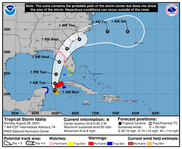
114952_5day_cone_no_line_and_wind.png

000
WTNT45 KNHC 280859
TCDAT5

Tropical Storm Idalia Discussion Number 7
NWS National Hurricane Center Miami FL AL102023
400 AM CDT Mon Aug 28 2023

Idalia has intensified overnight. Data from an Air Force Reserve
Hurricane Hunter aircraft showed believable surface winds of 50-55
kt and a central pressure falling to around 989 mb.
The wind data
is also confirmed by NOAA buoy 42056, located just southeast of
the center, which has reported maximum 1-minute adjusted sustained
winds above 50 kt within the past hour or two. These data support
raising the initial wind speed to 55 kt.

It seems like Idalia is finally on the move, with aircraft fixes
indicating a northward motion of about 6 kt. This motion should
continue through Tuesday as Idalia moves between a mid-level trough
over the central Gulf of Mexico and a strengthening ridge over the
Greater Antilles. The storm is likely to move faster to the
north-northeast and northeast by early Wednesday due to a deeper
trough that is expected to swing across the mid-western United
States. The new NHC track forecast is quite close to the last one
with little significant changes to the track guidance. It should be
emphasized that only a small deviation in the track could cause a
big change in Idalia's landfall location in Florida due to the
paralleling track to the west coast of the state.


The center of Idalia is on the northern edge of the deep convective
mass, a refection of moderate northwesterly shear, and the last
aircraft pass showed a vortex tilted southward with height. This
shear and structure should persist for about the next 24 hours,
helping to keep the intensity of the storm from increasing too
quickly despite the extremely warm waters it will be traversing.
The NHC short-term forecast will continue to indicate Idalia as a
hurricane near western Cuba, similar to the guidance.

Over the Gulf of Mexico, the environment is forecast to become
conducive for significant strengthening of Idalia due to a new
trough dropping south over the western Gulf of Mexico as a
upper-level ridge builds near the cyclone. Additionally, Idalia
will be moving over waters near 31C, and some of the guidance is
even indicating favorable jet dynamics on Wednesday with Idalia in
the right-rear quadrant of the jet over the southeastern United
States. The bottom line is that rapid intensification is becoming
increasingly likely before landfall, and the NHC forecast now
explicitly indicates it between 24-48 h in the forecast.
This is
consistent with almost all of the regional hurricane models and the
SHIPS rapid intensification indices, which are 5-10 times the
climatological mean. The new prediction shows a 100-kt hurricane
over the eastern Gulf of Mexico at 48 hours, but Idalia should keep
strengthening up to landfall along the Gulf coast of Florida.
Interests within the storm surge and hurricane watch areas are urged
to prepare for possible significant impacts and monitor future
updates to the forecast for this increasingly dangerous situation.


KEY MESSAGES:

1. Idalia is now forecast to become a major hurricane before it
reaches the Gulf coast of Florida. The risk continues to increase
for life-threatening storm surge and dangerous hurricane-force
winds along portions of the west coast of Florida and the Florida
Panhandle beginning as early as late Tuesday. Storm surge and
hurricane watches are in effect for portions of the west coast of
Florida and the coast of the Florida Panhandle, and residents in
these areas should monitor updates to the forecast and follow any
advice given by local officials.

2. Areas of flash and urban flooding, some of which may be locally
significant, are expected across portions of the west coast of
Florida, the Florida Panhandle, and southern Georgia Tuesday into
Wednesday, spreading into portions of the eastern Carolinas
Wednesday into Thursday.

3. Hurricane-force winds are expected across portions of far
western Cuba later today. Heavy rainfall is also expected across
portions of western Cuba and may produce areas of flash and urban
flooding as well as landslides across western Cuba.


FORECAST POSITIONS AND MAX WINDS

INIT 28/0900Z 20.1N 85.2W 55 KT 65 MPH
12H 28/1800Z 21.1N 85.1W 65 KT 75 MPH
24H 29/0600Z 22.6N 85.1W 70 KT 80 MPH
36H 29/1800Z 24.8N 84.8W 85 KT 100 MPH
48H 30/0600Z 27.7N 84.0W 100 KT 115 MPH
60H 30/1800Z 30.7N 82.1W 65 KT 75 MPH...INLAND

72H 31/0600Z 32.8N 79.0W 55 KT 65 MPH...OVER WATER
96H 01/0600Z 34.5N 72.0W 50 KT 60 MPH
120H 02/0600Z 34.5N 67.0W 50 KT 60 MPH

$$
Forecaster Blake
 
I hope none of you are sensitive to the barametric pressures. I'm having a hell of a time right now.
 
I hope none of you are sensitive to the barametric pressures. I'm having a hell of a time right now.

Sorry to hear this...I dont think it bothers me because I never notice anything when a storm is coming. Hope
you have some over-the-counter meds or something to help with it.
 
It's past time to give serious consideration of human exodus from Florida due in part to the consequences of rising ocean levels and increasing strength and occurrence of storms. Climate projections show the bottom third of Florida being completely submerged by 2100 with coastal cities being uninhabitable long before that. Florida Keys main roads are projected to be underwater in 2 years with portions of the keys underwater by 2045. Ground water contamination by salt water is already a pressing issue as well as the natural sinking of the state due to its porous limestone foundation.

While the entire state may not be submerged in the short or long term, those living in areas threatened by rising water levels will either leave or migrate into drier parts of the state. Millions of Floridians migrating further inland and the consequent crowding of those areas isn't a pleasant scenario.
 
@tyty333 You're in Brevard right? I heard that they called for voluntary evacs.

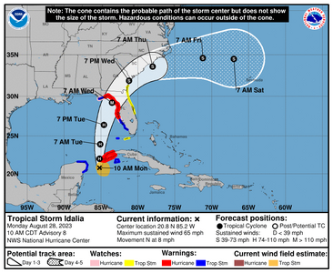
150039_5day_cone_no_line_and_wind.png


000
WTNT45 KNHC 281500
TCDAT5

Tropical Storm Idalia Discussion Number 8
NWS National Hurricane Center Miami FL AL102023
1000 AM CDT Mon Aug 28 2023

The satellite presentation of the storm has improved this morning
with the center more deeply embedded within the deep convection and
colder cloud tops. However, recent reconnaissance aircraft data
from both the U.S. Air Force Reserve and NOAA indicate that the
improved satellite presentation has not yet resulted in an
increase in wind speed. The Air Force Hurricane Hunter aircraft
has measured peak 850-mb flight-level winds of 68 kt, and a minimum
pressure around 990 mb
. Based on these data, the initial intensity
remains 55 kt this advisory. The Air Force aircraft will be in the
storm environment through early afternoon and that data should
continue to provide information Idalia's structure and intensity.

Recent satellite and aircraft fixes show that Idalia is moving
northward or 360/8 kt. A mid-level trough over the central
Gulf of Mexico and a ridge near the Greater Antilles should cause
Idalia to move northward at a faster forward speed during the next
12-24 hours. After that time, an even faster north-northeast
motion is expected an another mid-level trough moves across the
central and eastern portions of the United States. The latest NHC
track forecast is again quite similar to the previous forecast.
Although the track forecast has been quite consistent, there is
still some spread in the guidance by 48 hours, and it cannot be
emphasized enough that only a small deviation in the track could
cause a significant change in Idalia's landfall location in Florida
due to the paralleling track to the west coast of the state.

Although there is still some moderate northwesterly over the storm,
intensification seems likely during the next 12-18 hours, and
Idalia is forecast to become a hurricane during that time.
By
Tuesday, the environment over the eastern Gulf of Mexico is
expected to become more conducive for strengthening. Steady to
rapid intensification is predicted beginning Tuesday while Idalia
traverses the warm waters of the eastern Gulf and the upper-level
environment becomes more favorable. The NHC intensity forecast
again calls for Idalia to reach major hurricane strength before
landfall along the Gulf coast of Florida.

This forecast has necessitated the issuance of Storm Surge and
Hurricane Warnings for portions of the west coast of Florida and
Storm Surge and Tropical Storm Watches for portions of the Atlantic
coasts of Florida and Georgia.

KEY MESSAGES:

1. There is a danger of life-threatening storm surge inundation
along portions of the Florida Gulf Coast where a Storm Surge Warning
is in effect, including Tampa Bay and the Big Bend region of
Florida. Inundation of 7 to 11 feet above ground level is expected
somewhere between Chassahowitzka and Aucilla River. Residents in
these areas should follow any advice given by local officials.

2. Hurricane conditions are expected within portions of the
Hurricane Warning area along the Florida Gulf Coast, with the
potential for destructive winds where the core of Idalia moves
onshore. Strong winds will also spread inland across portions of
northern Florida near the track of the center of Idalia.

3. Areas of flash and urban flooding, some of which may be locally
significant, are expected across portions of the west coast of
Florida, the Florida Panhandle, and southern Georgia Tuesday into
Wednesday, spreading into portions of the eastern Carolinas
Wednesday into Thursday.

4. Hurricane-force winds are expected across portions of far western
Cuba later today. Heavy rainfall is also expected across portions
of western Cuba and may produce areas of flash and urban
flooding as well as landslides across western Cuba.

FORECAST POSITIONS AND MAX WINDS

INIT 28/1500Z 20.8N 85.2W 55 KT 65 MPH
12H 29/0000Z 22.0N 85.2W 65 KT 75 MPH
24H 29/1200Z 23.9N 85.1W 75 KT 85 MPH
36H 30/0000Z 26.4N 84.6W 90 KT 105 MPH
48H 30/1200Z 29.2N 83.5W 100 KT 115 MPH

60H 31/0000Z 31.9N 81.2W 55 KT 65 MPH...INLAND
72H 31/1200Z 33.6N 78.0W 50 KT 60 MPH...OVER WATER
96H 01/1200Z 34.6N 71.2W 50 KT 60 MPH
120H 02/1200Z 34.5N 67.0W 50 KT 60 MPH

$$
Forecaster Brown
 
I'm in Hillsborough county. I haven't even started anything yet. I don't feel a sense if urgency about this one for some reason even with the models.
 
I'm in Hillsborough county. I haven't even started anything yet. I don't feel a sense if urgency about this one for some reason even with the models.

I can only say I hope you'll be OK. I just saw that Hillsborough has Evacuations Orders for Zone A, which makes sense. I'm in PBC and its beautiful though wet and my head is literally telling me something crazy is about to happen.

I always hope for nothing burgers, no matter what some people think of me posting all this (I do it as a way to help others and relieve my own stress basically).

I agree - it's helpful! I was much more concerned about Ian last year for some reason. We are trimming back things tonight but largely have everything we need already.
 
GET 3 FREE HCA RESULTS JOIN THE FORUM. ASK FOR HELP
Top